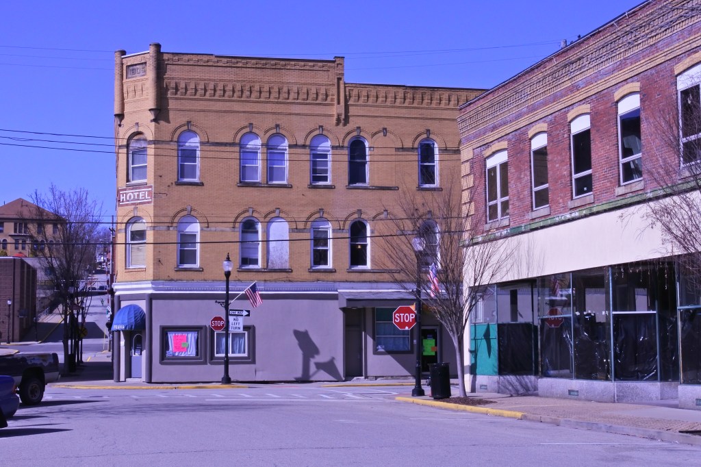
Greensburg, PA- County seat of Westmoreland Co. 30 miles outside of Pittsburgh

In the early 19th century, Greensburg had very little growth in population.  After 1850, Greensburg became a growing county seat with inns and small businesses. By 1870 it had 1,600 residents. The railroad and discovery of large areas coal reserves nearby added commerce and residents during the turn of the 20th century. Its population reached 6,500 in 1900 and doubled a decade later. Like most western PA towns Greensburg entered into decline after WWII but much less severe than other comparable cities due to its location as County seat and annexing a significant amount of its suburban growth. By the mid-1990s, city officials shifted revitalization plans to the cultural aspects of Downtown leading to projects like the Palace Theater and historic Train Station, as well the new Seton Hill performing arts. New businesses are filling many historic storefronts in Downtown Greensburg (especially along Main and Pennsylvania Avenues).

There area certainly plenty of areas Greensburg can improve from an urban perspective. First of all it has a very low population density making vibrancy and walkability more challenging. Its commercial district become mostly auto centric outside 1/2 mile of Dwtn, even if the surrounding neighborhoods were built before WWII. ADA and Bike infrastructure is certainly wanting and racial diversity is limited. Similar to Latrobe, an increase in immigration would provide many urban benefits to Greensburg.
Click here to view my album on Flickr

URBAN STRENGTHS:

* Good economic, and generational diversity.
* Generally a pretty same community although certainly a fair amount of blight, but not widespread vacancy in Greensburg.
* Nice amount of rental product that is generally affordable.
* Some excellent historic architecture, especially Downtown and in the more affluent north and east side neighborhoods.
* Solid tree cover.
* Several nice parks including St. Clair Park, the County Courthouse Plaza, Coulter Playground, Grove St. Park, and expensive grounds at Seton Hill, and Lynch Park (located just outside the city but close to Dwtn).
* Some nice cultural amenities here including: the Palace Theater, Greenfield Civic Theater, A Performing Arts Center, an Art Museum, decent amount of restaurants, bars, and cafes, several art galleries, and cultural offerings of Seton Hill.
* Decent neighborhood amenities including several supermarkets & Pharmacies, a Dwtn library and post office, Ollies bargain store, a hardware store, and plenty of boutiques, local clothing stores, antiques, banks, & jewelers in the Dwtn area. A full service hospital is located on the Westside of town.
* Good array of walkable schools including a Catholic elementary and high school along with a several public grade schools and a middle school. The Public high School is on the outskirts of town. 

URBAN WEAKNESSES:

* Decent ADA and sidewalk infrastructure. Some areas with missing or crummy sidewalks and modern ADA curb cuts is about 50% of all intersections.
* Decent public transit access in Dwtn and surrounding streets, but this drops off pretty quickly as one moves away from Dwtn.
* Nice recreational trail on the eastern side of Dwtn connecting to Youngwood. Other than this, bike infrastructure is limited.
* For sale housing is plentiful but generally pretty affordable. Also generally just SF options. Housing prices range from 50K-250K with more stable housing in the north and east sides of town.
* Solid walkability and urban form in the Dwtn area and on commercial streets extending about 1/2 out. Beyond this, the biz district become very autocentric and run down. 

Latrobe, PA- Childhood home of Mr. Rogers and Historic producer of Rolling Rock Beer.

Latrobe was founded in 1854 and quickly became a significant industrial hub due to its location along the Pennsylvania Railroad. Along with being the childhood of Mr. Rogers, Latrobe is famous for housing one of the largest breweries in the United States and the maker of Rolling Rock beer. Latrobe hit its population maximum in 1960 at 12K but is now down to just under 8K. This is actually a pretty manageable amount of decline for an old Pittsburgh steel town. Many are much worse off.

Latrobe has several nice blocks of in tact historic main street fabric along both Main St and Ligonier Ave. Certainly plenty of historic commercial buildings outside of this core area, but not great main street cohesion. Occupancy is spotty with some nice store fronts but plenty of vacancies or occupied 1st floor and vacant floors above.  Latrobe’s most stable housing market is east of Lincoln Ave where most homes sell well into the 100ks. The rest of Latrobe is mostly working housing selling between 50K and the low 100Ks.

To become a quality urban area again Latrobe should start with a Main St. revitalization focus reoccupying its storefronts and upper floors. This would certainly foster vibrancy and interest in the city. Other improvements include more walkable schools, better bike infrastructure, consistant ADA infrastructure, more rental options, and a hub for immigrants. Latrobe needs to more population and lacks diversity. With cheap housing, it is well poised to attract immigrants.
Click here to view my Latrobe album on Flickr

URBAN STRENGTHS:

* While there is certainly some blight in Latrobe crime is low.
* Very healthy medium income and a low poverty rate. High percentage of family households as well (nearly 60%).
* Solid park recreations well distributed throughout the borough.
* Decent walkable retail/neighborhood amenities including a Shop’n’Save, drug store, a library, post office, bakery, a dollar general, several boutiques, toystore, and a hospital.
* Some very nice historic architecture along Main St. and larger early 20th century historic homes on the east side of town.
* Decent urban form along Main St. for a couple blocks but it quickly breaks down to a semi-autocentric form. Ligonier also has a couple good blocks but then transitions into a gritty mixed-use street.

URBAN WEAKNESSES:

* Pretty poor density for an urban area.
* Generally consistent sidewalks and curb cuts but few ADA standard infrastructure.
* Limited bike infrastructure but a very nice recreational trail along the Lincoln and short path along the river.
* This a very white community (~96%) with limited racial diversity.
* Homes are very affordable but a stable market. Most homes sell between 50-200K. Some large mansions selling between 200K-300K.
* Rentals are very affordable but also limited.
* Cultural amenities limited to a handful of restaurants, bars, cafes, the Latrobe historic society, the Latrobe Art Center, and a couple other small art galleries.
* Walkable schools are limited to a public elementary, Catholic school and community college. The middle and high school are located out on the edges of Latrobe.

Bexley, OH Columbus’ most exclusive historic suburb

Founded as a village over a hundred years ago, Bexley is an old, tree-lined suburb of Columbus. By 1928 Bexley achieved a population of 5,000 and thus officially became a city in Ohio. By 1950 the City’s population reached 12K and has been mostly flat ever since. Thanks to is older fabric, Bexley scores pretty well from an urban and walkability perspective.

The historic suburb is also known for its large houses and estates and hosts the famous Jeffrey Mansion,  the home of the president of The Ohio State University, and the Ohio Governor’s Mansion. This certainly adds a layer of exclusivity and explains why Bexley scores low in diversity and affordability. Other urban areas for improvement include more density and better urban in-fill along its commercial district on Main St. Both of these improvements would also improve Bexley’s vibrancy and make it more inclusive.

Click here to view my Bexley album on Flickr
URBAN STRENGTHS

* Solid ADA infrastructure and generally sidewalks exist.
* Transit access is decent but only a 5-10 drive to Downtown.
* Several dedicated bike stations especially around Main St., and a nice dedicated north-south bike lane along Alum Creek but not convenient connections to Dwtn.
* Overall this is a very safe community, but not surprisingly pretty high number of burglaries.
* Great generational diversity with 71% family households and a large amount of college students as well.
* Several nice parks and recreational amenities including the Alum Creek Rec trail, Jeffrey Park, Nelson Park, and Walk Park. The Franklin Park Conservatory is also just across the river. These are also concentrated along the western edge of Bexley, so many portion of the neighborhood don’t have walking access to a park.
* Cultural amenities include a good array of restaurants, bars, and cafes along Main St., The Schumacker Gallery & Bexley Historic Society, the historic Drexel Theater, and an array of cultural offerings from Capitol University.
* Quality historic housing throughout, especially the mansions. Infill is a mixed bag depending on its urban orientation. City certainly has designs standards helping to avoid the worse modern architecture.
* Great tree canopy.
* Good retail amenities, although a mixed bag regarding orientation. 3 full service grocery stores, several pharmacies, bookstore, bike store, several boutiques, and plenty of banks.
* Good array of high quality public schools and several private schools as well. Families of means certainly move here for the schools.

URBAN WEAKNESSES:

* Not great density.
* Pretty limited racial and economic diversity.
* Rentals are very limited and what product does exist is primarily SF homes.
* For sale product is also expensive but some price diversity. South of Main St. is the most “affordable” portion of Bexley with plenty of modest SF homes selling in the 200Ks and low 300Ks.  Area around Broad has a decent amount of product selling btwn 350K-500K. Plenty of larger homes selling between 500K-1.5 Million north of Main St.
* Urban form of biz districts is a mixed bag. The western half of Main is good. The eastern half is pretty auto centric, although city appears to be requiring new construction to be oriented up to the street and there are sidewalks the entire length. The small stretch of urban comm along Broad is very auto centric. 

West Boulevard- A solid early 20th century district on Cleveland’s Westside ready to be noticed

West Boulevard developed around the turn of the 20th century as Cleveland’s streetcar system extended outwards, primarily along Lorain. W 105, Memphis, and Dennison were also built as mixed-use streets although they have experienced a good amount of blight and auto centric development. Large homes were built on set back lawns along the curvilinear West Blvd. This homes demand the highest prices in the neighborhood generally btwn 150K-200K.

West Boulevard started declining probably in the 70s but has retained most of its housing stock. (The portion of the district east of Dennison is the most blighted abutting Stockyards). Like Jefferson to the west it has remained static for decades, but households are less wealthy. This is also one of Cleveland’s most diverse districts hosting large Hispanic, Middle Eastern, Black, and Asian Populations. My hope is that the general revitalization of nearby Cleveland westside districts (Lakewood, Kamm’s Corner, and Detroit Shoreway) will arrive to West Boulevard. I’d love to see the Lorain Station commercial district (btwn West Boulevard and W. 90th) revitalize as it contains most of its attractive early 20th century 2 story fabric.

Click here to view my West Boulevard album on Flickr

URBAN STRENGTHS:

* Better urban form along Lorain between W 117th W 92nd especially in Lorain Station section.
 Many large stately homes from the early 20th century with massive years along West Boulevard.
* Excellent racial diversity and decent economic and generational diversity.
* Convenient access to Dwtn with solid public transit service.
* Good array of parks west od Dennison Street. Really no recreational spaces east of Dennison St.
* Indoor mountain bike park within an old industrial site.
* Very good ADA and sidewalks infrastructure.
* Some very nice homes especially the quasi-mansions along West Blvd. Also some crummy woodframe worker housing not maintained well, especially east of Dennison St.
* A good amount of school options K-8 mixing private, public, and charter options. Mixed however in terms of quality education. No walkable High Schools.
* Decent urban commercial massing especially along Lorain street where much of the historic commercial is still in-tact even with high vacancies. Recent streetscaping project along Lorain as well.
* Decent amount of retail amenities including a discount supermarket, many ethnic grocerias & markets, a drug store, public library, Shoppers World (like k-mart), Rainbows, a fabrics store, good array of banks, and several discount boutiques. 

URBAN WEAKNESSES:

* Moderate level of vacancies in commercial district and residential especially east of Denison.
* Limited bike infrastructure.
* Rentals are kinda limited but generally very reasonably priced.
* For Sale product is a mix of stable and standing but blighted. Majority of housing sells between 50K-100K. But some below 50K. Larger well maintained homes will sell between 100K-150. Some of the larger homes along West Blvd are pushing 200K. Sale prices are too low for any quality new in-fill. In-fill is generally crummy auto centric stuff.
* Good amount of rental product but all pretty inexpensive. Mix of decent and poorly maintained rentals.
* Cultural amenities are pretty limited but include a decent array of ethnic restaurants, lots of dive bars, and several cafes.

Jefferson- A stable working class neighborhood on Cleveland’s Westside

Jefferson is a staple middle/working class district on Cleveland’s Westside with relatively good occupancy and in tact urban form. It is also a very affordable neighborhood  attractive to immigrant groups and one of Cleveland’s most diverse areas. About 14% of the population is foreign born and over half of the population is a minority. One can find an array of ethnic restaurants, bakeries, markets, along Lorain and West 105th Street.

The district also excels at great transit access and park recreation. It has decent walkable schools. ADA infrastructure, historic homes, and connectivity. My hope is that the general revitalization of nearby Cleveland westside districts (Lakewood, Kamm’s Corner, and Detroit Shoreway) will arrive in Jefferson. The neighborhood has good urban form but has remained in a similar place for many decades leading to a static maintenance of existing homes and commercial fabric with very little new urban infill. The biggest urban areas to improve include: urban infill long Jefferson’s commercial districts and more cultural and neighborhood amenities.
 
Click here to view my Jefferson Album on Flickr

URBAN STRENGTHS:

* Highly diverse neighborhood including sizable Middle eastern and Hispanic community. Considered the center of Middle Eastern community at Lorain and West 117th in Cleveland. Also great economic and generation diversity. Lots of families here.
* Excellent public transportation access especially along Lorain and near the Red Line Transit Stations.
* Many attractive brick and wooded streets with solid owner occupancy.
* Recent streetscape investments on Lorain west of W. 117th including mid-block pedestrian crossing.
* Several great park assets pretty well distributed throughout the neighborhood including Gunning Park Recreation Center, Jefferson Park, Halloran Park (includes an indoor ice rink), Mohican, and Worthington Park.
* Pretty good pre WWII architecture mixing in brick and woodframe styles. Historic commercial is mostly 2 story brick structures.
* Good Tree canopy.
* While not all the schools are highly rated, good mix of walkable schools including several grade schools and the John Marshall High School focusing on engineering.
* Culturally a wonderful array of ethnic restaurants, several diverse bars, and some cafes. Not much else culturally.
* Good array of retail amenities although much of them are auto centric. This includes a target, office max, tons of ethnic grocerias, a couple supermarkets, several drug stores, post office,  a hardware store, and other typical neighborhood retail.

URBAN WEAKNESSES:

* Rentals are kinda limited but generally very reasonably priced.
* For Sale product is stable but pretty inexpensive. Most homes sell between 75K-150 and are 3 & 4 bedrooms with decent sized yards. Great neighborhood for a starter home. Some nicer product between 150-200K. But sale prices are too low for any quality new in-fill. In-fill is generally crummy auto centric stuff.
* Some blight in the neighborhood especially along the commercial districts where there is a fair amount of unoccupied store fronts
* Limited bike infrastructure.
* Urban form of commercial district is a mixed bag. Decent stretch along Lorain between W 136 and 117. The W 117 & Lorain node has the best form. Some very auto centric areas near Lorain and W 140th. parts of W 117th, Puritas, and W 150th. 

North Clintonville- A Columbus neighborhood that bridges the gap between American’s streetcar and autocentric eras

North Clintonville is the northern half of Clintonville north of Henderson/Cooke. It includes the sub-district of Old Beechwold, East Beechwold, and Sharon Heights. Old Beechwold is a historic development from the pre-WWII era that was developed after the failure of an early Columbus Zoo. Here, single family homes using stone, brick, and stucco are set on well canopied curvilinear streets. East Beechwold is a bit newer mixing homes from the 1920s-1950s. Sidewalks in both neighborhoods are hit or miss. Sharon Heights is consistently the most suburban of the sub-districts with housing squarely between the 1940s-1960s and limited sidewalks.

The Beechwold business district along High Street between Henderson and Morse Road is the most urban in North Clintonville. It has clusters of businesses with urban orientation and walkability but lacks consistently. Remaining commercial districts are pretty auto centric across the district.

North Clintonville excels in providing quality amenities such as good parks, quality housing, low crime, and good retail amenities, although often oriented towards cars. Because the neighborhood bridges the early 20th century streetcar era and the full auto centric era, it has a lot of suburban tendencies that prevent it from being a viable urban district. But with some intentional urban commercial overlays and densifications, North Clintonville could become a viable urban district. It certainly has the enough quality public transit access and connectivity to pull it off. 
Click here to view my Beechwold album on Flick

URBAN STRENGTHS:

* Some very nice stretches of historic homes old Beechwold and East Beechwold sub-districts. Nice 1920s-1940s brick housing with some older woodframe. Plenty of blah 1950s-1960s housing as well.
* Good access to Dwtn and surprisingly good transit access.
* A pair of north-south bike paths running along the western and  eastern edges of the district.
* Plenty of housing product selling between 200K-500K depending on condition and size. Vast majority of this are SF homes but some condos mixed in as well. Top of the market is larger SF homes selling btwn 500K-700K. The majority of these are in the Old Beechwold subdistrict.
* Several nice park and recreational amenities including the Olentangy River Trail, Beechwold Ravine, Overbrook Ravine, Kennedy Park, Broadmeadows Parks, Rush Run Park, and Sharon Meadows Park.
* Very safe neighborhood. Limited blight.
* Cultural amenities include a good array of restaurants (although many are fast food joints), bars, and some cafes.
* Good neighborhood amenities but most of them are auto centric. A couple supermarkets & drugstores, a post office, a couple bookstores, several boutiques, plenty of banks, a hardware store, a target, and other general retail especially in the Graceland Shopping center.
* Other than the Graceland Shopping Center and some WWII developments, great tree canopy in North Clintonville. 

URBAN WEAKNESSES:

* Poor Density. More similar to a suburb.
* Commercial districts are mostly auto centric but some climbs of good urban form along High Street between Cook and Morse Road.
* Some ADA infrastructure and sidewalks south of Morse but its really hit or miss. Sidewalks are mostly non-existent north of Morse in the Sharon Heights sub-district.
* No dedicated bike stations though in this portion of Clintonville.
* Some rentals but almost all of them are 2 & 3 bedrooms. s generally at moderate rents. Mix of moderate and more expensive rentals.
* Pedestrian traffic is pretty limited.
* Really no museums here although there are several old historic sites just north in Worthington. No theaters and limited live music and art galleries.
* Hospitals and library are located in adjacent districts, but one most drive there.
* Lots of quality schools south of Morse Street. Only one in North Clintonville.
* Some decent commercial infill built to the street but also lots of unattractive auto centric buildings. 

Clintonville- Columbus’ most white-collar urban district

Clintonville for much of the 1800s was the “empty space” between Old North Columbus and Worthington along the High Street stage coach route. In an attempt to draw others to the area the Bull family built businesses in the center of Clinton Township, along North High Street in the mid 1800s. By the early 1900s, downtown Columbus residents and Ohio State professors built summer homes here. Eventually, with the extension of streetcar lines into the neighborhood, Clintonville filled in.

Clintonville never really lost its market strength and luster the several decades after WWII. But High Street and Indianola lost much of their urban fabric due to miss guided auto centric development. Since the 2000s the Clintonville housing market has strengthened even more and now most homes sell in the 300ks and 400ks. Its high market value is due to Clintonville’s strong schools, great parks, large back yards, safety, and convenient access to Dwtn and Ohio State. There are several urban areas for Clintonville to improve including more quality urban infill along its commercial corridors, more density, better bike infrastructure, and more intentional affordable housing. Clintonville residents, while mostly liberal, can be rather Nimbyistic blocking quality urban in-fill and affordable housing projects.
Click here to view my Clintonville album on Flickr

URBAN STRENGTHS:

* Okay access to Dwtn but very convenient access to Ohio State, obviously another major jobs center.
* Good number of rentals generally at moderate rents. 1-bedrooms btwn 700-$1,000, 2-bedrooms btwn $800 and the low $1,000s, and 3-bedrooms generally in the mid $1,000s.
* Excellent tree canopy.
* Great park amenities including the Olentangy trail and several large adjacent green spaces, the expansive Columbus Park of Roses, several ravines and sports fields.
* Culturally Clintonville includes a nice diversity of restaurants, bars, & cafes, a local movie theater, a handful of art galleries, and the Columbus Civic Theater.
* Good neighborhood amenities, although often with more suburban form. This includes several full sized supermarket, a public library, a couple drug stores, several, book stores, a good array of boutiques, and other general retail services.
* This is a very safe community with limited blight.
* Great array of public/private schools well representing K-12. 

URBAN WEAKNESSES:

* Bike infrastructure is ok. A couple bike lanes and one dedicated bike station.
* For Sale housing is on the high side but still a decent amount of diversity. Good amount of modest SF housing selling in the 200Ks. Most product of 3 & 4 bedroom well maintained homes sell in the 300Ks & 400Ks. L
*Larger SF homes sell in the 500Ks & 600Ks.
* Ok racial and economic diversity.
* The urban form of Clintonville’s business districts is hit or miss. Some nice stretches of urban form along High Street (especially near Como) and a nice node on Indianola. But large primarily auto centric stretches on both streets, especially Indianola.
* Limited modern in-fill and what does exist is mostly autocentric. 

Merion Village- Another quality Columbus Urban Neighborhood on the Southside

I followed the traditional boundaries of Merion Village but exclude the industrial portion of the district west of High Street. Very few people live here.

The district is named after the Merion family who settled in Columbus in 1809 and purchased  1800 acres of land which became Merion Village. Development started in the district in the 1830s with the construction of local canals. The Merions made sure that their holdings near the Scioto river became the industrial hotbed of Columbus. The residential component of the neighborhood east of High Street (where this evaluation begins) developed generally after the Civil war starting along its northern edge abutting German Village and working its way south towards Hungarian village. Most of the neighborhood was developed around the turn of the 20th century.

Merion Village witnessed some disinvestment starting in the 60s & 70s but nowhere near the level experienced in Black majority districts like Olde Towne East or Driving Park. Its main commercial corridors (High and Parsons) experienced the most blight with these scars are still very visible today. Reinvestment has slowly moved southwards from its border with German Village since the 70s. As a general rule of thumb real estate prices are highest near German Village and lowest in the district’s southern border.

Overall Merion Village is a solid urban district, which will continue to improve as it receives more investment. The most important areas it can improve upon include: revitalizing its commercial corridors along High and Parsons, adding more bike lanes, attracting missing neighborhood retail amenities, and being attentive to providing affordable options as real estate prices climb. 
Click here to view my Merion Village album on Flickr

URBAN STRENGTHS:

* Overall public transit service is pretty good, but better closer to German Village. Still very convenient access to Downtown.
* Great connectivity and street grid.
* Great economic diverse, probably the best in all of Columbus.
* Diverse For Sale housing with un-renovated by solid homes selling in the 100Ks and low 200Ks. Modest but renovated homes selling between 225K-350K. Larger renovated homes selling generally btwn 350K-600K. But given the rapid rise in value in Cbus, low-moderate income residents will soon be priced out of homeownership.
* Decent array of rental product with higher end product closer to German Village and more moderate rates further south.
* Generally a safe neighborhood but still some blight and rough patched along Parsons and southern end of High Street.
* Convenient access to Shiller Park for most residents. This is one of Columbus’ best urban parks. Also a couple ballfields next to the elementary school and a nice green space at Moeller Park.
* Generally high quality sidewalks and consistent proper ADA infrastructure.
* High quality architecture especially the northern half near German Village which is mostly brick. Homes transition to mostly woodframe construction the further south one goes.
* Culturally Merion Village includes a nice array of restaurants, bars, and cafes esp. along Thurman and Whittier. Some stuff on High and Parsons. Also some nice live music venues.
* Neighborhood retail amenities include a supermarket, bakery, CVS, public library, a book store, a hardware store, a music shop, and the Columbus Community Hospital.
* Pretty good access to schools including two public elementary schools and South High School. Also a couple Christian schools as well.

URBAN WEAKNESSES:

* No bike lanes throughout Merion Village but there are several bike sharing stations.
*Racial and generational diversity is decent but not great.
* Some nice residential infill near German Village, but also plenty of newer suburban uses along Parsons and High Street.
* Really no art galleries, museums, or theaters in Merion Village. Although a couple theater companies are located to the north in German Village.
* Missing neighborhood amenities include a post office, retail banks, boutiques, and other clothing retailers.
* Urban massing and quality streetscaping is a mixed bag in Merion Village. Along the major commercial corridors (High and Parsons) is a mix of good urban blocks, auto centric blocks, and deterioration. There are also several very mixed-use nodes along Thurman, Whittier, and the 4th & Moler node where the urban form and streetscaping is quite good. 

Olde Towne East- Columbus’ best Victorian Architecture

Olde Towne East is one of Columbus’ oldest neighborhoods. Development started in the early 1800s with the neighborhood filling in mostly during its post Civil War boom. From this period comes the unique architectural style of Olde Towne East and a good deal of social mixing where rich and poor residents lived in close proximity to each other. Following World War II Olde Towne East went into decline and many of its grand homes of the late 1800s began to deteriorate or were subdivided into apartments and rooming houses.

Revitalization efforts started in the early 1970s as many parts of the neighborhood, particularly surrounding Bryant Street, were historically designated. This encouraged a slow but persistent restoration of these grand homes. By the early 2000s revitalization became more wide spread focusing on rebuilding the Parsons-Oak commercial node. And finally by the mid 2010s the whole district was revitalizing leading to new construction and sales prices extending into the 400Ks. Right now, the Olde Towne East has a nice range of for sale prices between 100K-500K but I fear this will not last, and the neighborhood will be out of reach for many low-moderate income households.

From an urban perspective Olde Towne East is well served by public transit and only 1-2 miles from Dwtn Columbus. It’s retail amenities are still fairly modest but improving (especially at the Oak and Parsons node). My hope is that its main Thorofare along Broad starts to see more development and large mixed-use infill. There are still many vacant lots and buildings to revitalize giving Olde Towne East a bright urban future. I also hope the city permits more mixed-use zoning along more diverse and creative uses to integrate with parts of the neighborhood removed from the Parsons-Oak Commercial node.
Click here to view my Olde Towne East Album on Flickr

URBAN STRENGTHS:

* Fantastic access to Dwtn Cbus being only 1 mile away. Solid public transit as well.
* Great racial and economic diversity. Decent generational diversity with 1/3 of households as family households.
* Good amount of rental housings moderately priced (i.e. 1 & 2 bedrooms around $1,000 and 3 & 4 bedrooms in the $1,000s).
* Good variety of for sale prices, although I do fear that the neighborhood’s rapid appreciating value will start to become cost prohibitive to many long term residents. Homes generally stay within 100K-600K. Modest or unrenovated homes sell between 100-250K. Renovated by smaller homes between 250-400K. Larger renovated homes sell in the 400Ks & 500Ks.
* While many still write up the neighborhood as dangerous there is most certainly a buzz here.
* Wonderful set of historic Victorian homes.
* Cultural amenities include a good set of restaurants, cafes, bars, and some live music venues & art galleries. Some nice museums in surrounding districts like the Kelton House Museum & Garden, and the Franklin Park Conservatory , the Columbus Art Museum, and Botanical Gardens.
* A handful of schools located with Olde Town East and several in nearby Franklin Park.
* Not a ton of urban in-fill but some nice Residential and mixed-use projects starting to arise. 

URBAN WEAKNESSES:

* Decent but not great density. Hopefully as the neighborhood fills in, this will improve.
* Bike infrastructure is decent with one dedicated north to south route and a couple bike station. The district needs an west to east route that connects to Dwtn.
* Still a fair amount of blight even if the neighborhood isn’t dangerous anymore.
* Parks and amenities are a bit limited but not bad. Parks include Blackburn Park, a Recreational Community Center, and a nice playground.
* Retail amenities are a bit limited as there are not supermarkets, drug stores, post office, banks nor library. But the neighborhood includes some nice boutiques, a wine store, a florist. Children’s hospital however is just south of the district and adjacent Dwtn also has some nice amenities.
* The urban commercial node at Parsons and Oak is attractive (with good urban form and streetscaping) but only extends a couple of blocks. Because of its location on the western edge of the neighborhood, commercial is limited in the middle and eastern section of Olde Towne East.

Dennison Place/South Campus- The often forgotten neighborhood between Columbus’s Victorian Village and Ohio State

The district stretches between 5th to Ohio State to the north. This includes several smaller sub-neighborhoods of Dennison Place, the Circles, Necko, and South Campus.

Dennison Place and Necko was mostly built out by 1900 with great historic Victorian style homes. The area began to decline in the 1930s as Columbus expanded and people began to move to the suburbs. By the time decline bottomed out in the 1970s, many of the original homes were converted to rooming houses or knocked down to make room for modern apartment buildings, or simply abandoned and boarded up. This sparked neighborhood preservation policies and new zoning to prevent further destruction.  By the 1980s, the revitalization of Dennison Place/Necko started with the restoration of its historic Victorians. Now these homes sell between 500K-1 Million. The fate of South Campus was more like the University District. A post WWII demand for housing led to new apartment buildings and larger homes being transitioned into multi-family. The area is still a heavily students. High Street has seen significant revitalization including a slue of new mixed-use infill buildings.

Areas where the neighborhood could improve from an urban perspective include: more for-sale housing diversity, better park and recreational spaces, and walkable schools.
Click here to view my Dennison Place Album on Flickr

URBAN STRENGTHS:

* Great population density.
* Good historic architecture especially in the Dennison Place/Circles and Necko section.
* Great access to job centers across all modes. 1 mile to OSU and 3 to Dwtn Cbus.
* Good coverage by the City’s bike sharing system.
* Decent racial diversity thanks to the large international population at OSU.
* Lots of rental options and most of them moderately priced. Some higher end rentals as well.
* Cultural amenities include a good amount of restaurants, bars, and cafes, a cineplex, several live music venues and art galleries, and convenient proximity to OSU’s cultural activities.
* Quality retail amenities a supermarket, several drug stores, a Barnes & Nobles bookstore, a public library, several boutiques, banks and other neighborhood serving retail. Parts of High St in OSU and the Short North are also walkable to residents living here. This includes the OSU Target.
* Great urban massing and streetscaping along High Street. Also a quality urban node at Neil and 10th. A couple other nice mixed use blocks sprinkled throughout. 

URBAN WEAKNESSES:

* Surprisingly the Olentangy recreation trail is the only dedicated bike path in the neighborhood. This does, however, provide a nice safe route to Dwtn.
* For sale housing is generally expensive but some more modest options with 1-2 townhome condos selling in the 200Ks. Smaller SF homes or less updated ones selling btwn 300K-500K. Larger renovated historic homes selling anywhere from 500K-1 M primarily in the Dennison Place/Necko section.
* Parks are pretty limited within the district although the Thompson Park (complete with a community center) sits on the district’s southern edge, OSU’s open space is nearby, and the Olentangy Recreational Trail on the western edge.
* No schools within Dennison Place/South Campus but some in surrounding neighborhoods.
* Modern in-fill is mixed bag. Some good off campus housing built by OSU are Neil and 11th Street and more and more quality mixed-use in-fill filling in along High Street. But plenty of post WWII garbage apartments in South Campus area.