Featured

Observatory Hill- Pittsburgh’s Highest Point

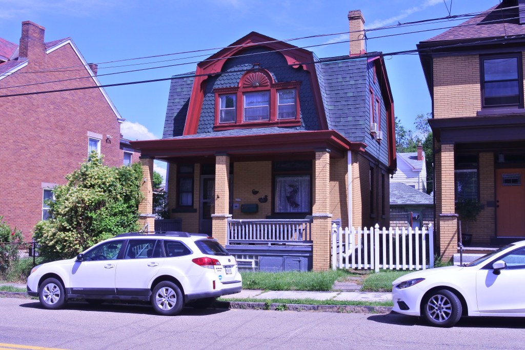
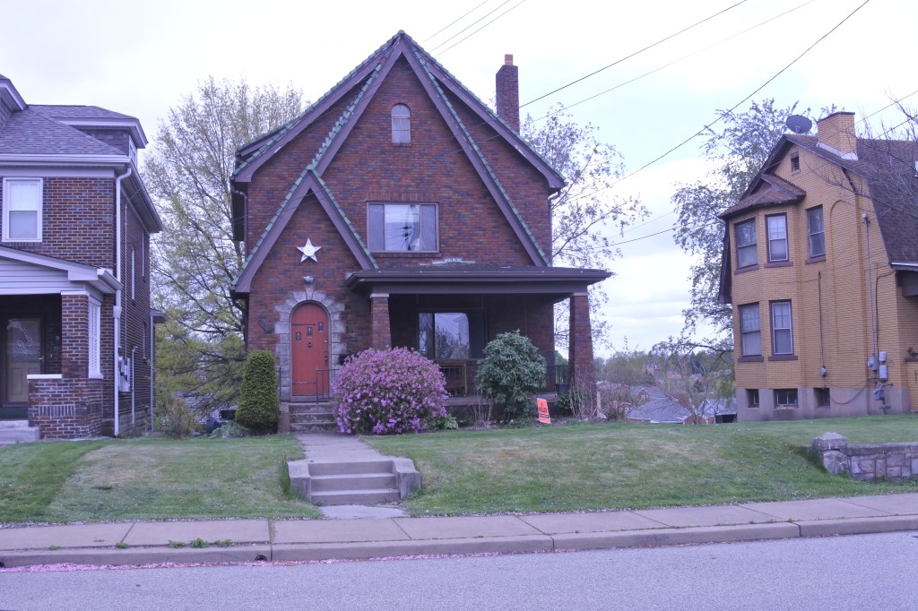
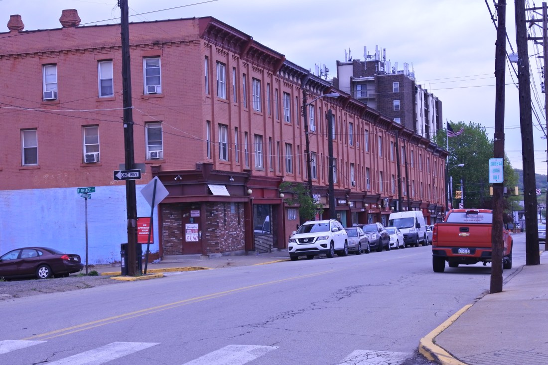
Observatory Hill or Perry Hilltop was named both in honor of Commodore Perry and the Historic Allegheny Observatory, the City’s first astronomy building gracing the top of Riverview Park. The district also hosts the highest elevation in the City of Pittsburgh at 1,370 feet at the Brashear Reservoir and WPNT-FM  Radio Tower.

This North Hills district has remained a middle class strong hold in the northside and thus retained much of its historic housing and fabric. Riverview Park was a large factor in the neighborhood’s success. Observatory’s urban business district along Perrysville Ave has not fared as well and is littered with vacancies and limited retail amenities. Cultural amenities are also very limited. Building up the Perrysville Avenue business district should be the # 1 revitalization priority for the neighborhood. Secondary priorities include installing bike infrastructure, permanent affordable housing, opening new high quality schools, and improving pedestrian and ADA infrastructure.
Click here to view the full Observatory Hill Album on Flicker

URBAN STRENGTHS:

* Convenient access to downtown especially via the car but decent transit and biking routes.
* This is a very diverse neighborhood among all measures.
* Very diverse for-sale price points starting at around 50K for a modest fixture upper to the 200Ks for a large historic home and everything in-between.
* Riverview Park is accessible to all in the neighborhood and holds almost any recreational amenity one needs.
* Overall pretty safe district, although some blight still remains.
* Lots of high quality historic architecture.
* The urban form of the business district is good but very small.
* Great tree cover.

URBAN WEAKNESSES

* Streets generally connect but are very curvilinear due to the district’s extreme terrain.
* Other than bike lanes in Riverview, Bike infrastructure is non-existent.
 * Not a ton of rental product but generally affordable. 1-bedrroms run between $500-$700, 2-bedrooms btwn $700-$1,100, and 3-bedrooms to the low to mid $1,000s.
* One deli and no restaurants or bars.
* Cultural amenities are basically non-existent. One needs to travel several miles south to the Allegheny Commons district and Downtown.
* Low-Medium density.
* Other than a couple convenience stores there is a bank, hair salon, thrift store, but not much else in the way of retail here.
* Perry High School is located here but rated poorly. No other schools within Observatory Hill.
* Most roads host sidewalks and ramps but ADA infrastructure is often missing.
Featured

Marshall-Shadeland, a Northside Pittsburgh Community with great Urban Potential

Marshall-Shadeland is a largely residential area that was annexed by Allegheny City in 1870. Growth followed and the neighborhood filled in by the early 20th century. Most housing was constructed for workers but some larger homes reside along Brighton and Woodland along with 1920s and 1930s in-fill in the north edge of the district. Decline probably began shortly after WWII and accelerated in the 70s and 80s.

Fortunately much of the urban fabric remains and there is hope that the district will once again become a thriving urban community given its convenient access to downtown and proximity to other stable districts (i.e. Brighton Heights, Mexicantown, West Allegheny, and increasingly Manchester). Recent renovations have occurred resulting in home sales in the 100Ks. Yet much blight remains and there is a lack of neighborhood retail and cultural amenities.

Click here to view the entire Marshal-Shadeland Album on my Flickr Page.

URBAN STRENGTHS

* Good access to downtown vial all modes of transportation.
* While there are no bike stations here dedicated bike lanes run down Brighton Rd and along the river.
* Great generational and ethnic diversity here.
* Fair amount of rental product at moderate prices. 1-bedrooms go for around $600-$800 and 2 & 3-bedrooms between $900-$1,100.
*For sale housing is very affordable with prices ranging anywhere from 30K to 180K depending on size and quality.
* Decent park amenities including two ballfields, a parkette, several cemeteries, and decent access to Riverview Park.
* Because of the hills and ravines there is overall great tree canopy. The neighborhood could use more street trees however.
* What does exist of Marshall-Shadeland’s business district (node at Marshall and Woods Run) is pretty urban. But its rough and there the streetscape is lackluster.

URBAN WEAKNESSES

* Some economic diversity, but pretty low-income area.
* Lots of vacancies throughout district.
* There is still a perception of crime here.
* Some retail amenities including a Kuhn’s Supermarket, Dollar Store, Wine & Spirits, a Café-restaurant, and several low key restaurants and bars.
* Very little nightlife in the district other than a couple restaurants and bars but Marshall-Shadeland does have convenient access to other vibrant areas such in the northside (Mexican War Street, West Allegheny, etc.).
* Even with some recent revitalization successes Marshall-Shadeland still retains a pretty negative perception.
* ADA is a mixed-bag here. The main streets and flat areas are well served by ADA infrastructure. Hilly and more obscure streets often have limited ADA or no sidewalks.
* A couple specialty schools within the district but nothing else. Several schools lie in adjacent districts but generally not well rated.
* Really no cultural amenities within Marshall-Shadeland but convenient access to what lies in West Allegheny and Mexicantown districts.
Featured

Spring Hill- One of Pittsburgh’s Great “View” Neighborhoods

Spring Hill was named for the abundance of springs near the site. Germans immigrated there from 1850 to 1920, giving the neighborhood a very Bavarian atmosphere reflected in its local streets (i.e. Rhine, Woessner, Haslage, Zoller and Goehring). The population of Spring Hill peak in 1940 around 8,000 and has stabilized down to around 2,500. Spring Hill Garden used to host around 4,000 and now is just under 1,000.

This is a very typical hillside Pittsburgh community, which has seem a drastic population loss but has managed to “right size” through losing population often in the most steep terrain and maintaining generations of families. Spring Hill and Spring Garden are beginning to see modest real estate interest given its close proximity to downtown and other revitalizing communities such as Deutchtown and Mexican War Streets. The old warehouses of Spring Garden are beginning to see new life through modern craft outfits, distilleries, and fitness centers. To elevate this district to a viable urban community continued real estate investment, new bike paths, improved public transit connections, and a walkable neighborhood amenities are needed. But this is certainly possible given the neighborhood’s good urban bones, proximity to downtown, and beautiful views and generous yards.
View the full Flick Albums for Spring Hill and Spring Gardens

URBAN STRENGTHS

* Good access to downtown especially by car, but decent public transit access. One could even walk to downtown in 30-45 minutes if they can handle the terrain. Getting to Oakland is much harder by transit by easy by car.
* All around great diversity in Spring Hill.
* For sale housing is very affordable with prices ranging anywhere from 25K to 150K depending on size and quality.
* Great tree cover thanks to all the steep terrain and hillsides.

URBAN WEAKNESSES

* Very low density for an urban district due to the extreme topography and steep population decline.
* No bike infrastructure across the district.
* Not much rental product in the neighborhood and what exist is very modest.
* There are a couple parks hosting ballfields, playgrounds, and the Lutheran cemetery.
* Sidewalks are often missing and very steep terrain, so ADA infrastructure isn’t great.
* Commercial is very limited (a brewery within the Spring Hill district but some neighborhood amenities existing on Spring Garden Road (i.e. pharmacy, family dollar, some light manufacturing, a cider house, and a couple of bars and restaurants.
* Very limited cultural amenities within the district, but the rich cultural of the northside and downtown is only 2 miles away.
* There is a poorly rated elementary school but not much else. 
Featured

Pittsburgh’s Troy- the Plateau that looks over the City

Originally called the village of New Troy, the neighborhood was originally settled by German immigrants who worked in the mills, tanneries, breweries and railroads that lined the Allegheny river (including the Heinz Ketchup factory). Migration up to Troy Hill began when a Catholic church opened a small cemetery in 1842. Gradually the neighborhood filled in by the early 20th century and remained a stable working class community to the present day.

While Troy Hill lost a significant amount of its historic population, dropping from a historic high of 7,000 to around 2,000, it has retained much of its urban fabric due to the removal of many hillside dwellings and smaller families. The neighborhood has stabilized and seen recent investment with many younger families renovating modest rowhouses. Given the districts incredible access to downtown, the Strip District, and Allegheny Commons, it is a surprise the market has not taken off even more here. Hopefully more and more amenities move to Troy Hill without it becoming too expensive for its current population. The neighborhood is one of the most economically diverse in the City of Pittsburgh.

Click here to view my full Troy Hill album on Flickr

URBAN STRENGTHS

* Pretty easy access to downtown especially for cars, but decent public transit access. Due to the hikes, bike commuting is challenging.
* Housing is pretty affordable here. Most homes selling in the $100s but some outdated product selling between 50-100K and larger resent renovations selling in the 200Ks. 1-bedroom rentals going anywhere between $700-$1,200 and 2-3 bedrooms in the low to mid $1,000s.
* Good recreational amenities with several ballfields, a few playgrounds, and a spray park.
* Streetscape and urban form pretty solid in the heart of Troy Hill along Lowrie St, but pretty weak along Spring Garden Rd. (the district’s northern edge).
* Good tree cover due to the many dense groves along the hill sides. 

URBAN WEAKNESSES
* No bike lanes through the hard of Troy Hill nor any bike stations, but a dedicated lane along 28.
* Culture amenities are decent but not great in Troy Hill. The neighborhood hosts a couple of restaurants, a café, two breweries, and several bars. This is also the home of St. Anthony (the largest collection of relics.
* Some neighborhood retail including several delis, a drug store, a fitness center, and several banks.
* Three schools within or in adjacent districts, but overall low ratings. 

Featured

Lincoln-Lemington- Pittsburgh’s “forgotten” East End Neighborhood

Lincoln-Lemington-Belmar is a predominantly black neighborhood that was majority Caucasian from the 1920s until the 1970s.Sadly the neighborhood fell into decline after its racial transition. What was once a comfortable early 20th century bedroom community with an intact main street now is a half empty with most of its main street erased.

Yet there still are several assets worth mentioning including its attractive early 20th century architecture, good public transit access, short commute to downtown,  quality park amenities, and thick tree canopy. There is much revitalization work needed to make this a viable urban community once more. Given its high home ownership, and the ability to build African-American wealth, this seems like a worth endeavor. 
Click here to view my Lincoln-Lemington album on Flickr.

URBAN STRENGTHS

* Decent public transit access and easy drive to Downtown.
* Good historic architecture. Just not always well maintained.
* Decent park recreation’s with several playgrounds, ballfields, and a recreational center.

URBAN WEAKNESSES

* Not great racial nor economic diversity. Still a high rate of poverty here.
* For-sale housing is depressed but some quality product selling between 50K-75K. Not a ton of rental product but generally a mix of affordable and moderate rental.
* Retail and stores limited to a couple convenience stores, car repair stores, and churches.
* Mediocre ADA infrastructure.
* Very limited cultural amenities.
* Some assemblance remains of the historic urban streetscape along Lincoln Ave but not much is left.
* No walkable schools in Lincoln-Lemington a couple in adjacent districts but not highly rated.
Featured

Morningside- A tight-knit Pittsburgh Community

Morningside development really took off around 1905 with the creation of the Chislett Street trolley line extended from Stanton Avenue into the neighborhood. The community was fully filled in with houses and a  some small commercial district by the 1930s. Morningside first welcome Irish families and eventually large numbers of Italian families ending Pittsburgh’s last wave of Italian immigration in the 1970s.

Morningside never experienced significant crime and blight issues but has seen a resurgence in interest in the past 5-10 years. Buyers are attracted by Morningside’s front porches, tight knit community, historic homes, convenient access, and modest back yards- a premium in the City. Renovated homes are now selling in the high 200Ks-300Ks. Morningside also has quality recreational spaces within the neighborhood and adjacent districts. What is needed for Morningside to transition from a good urban district to a great one is more dedicated retail and entertainment options, some additional multi-family housing , quality walkable schools, and dedicated bike infrastructure.
Click here to view my full album for Morningside in Flickr
URBAN STRENGTHS

* Good access to downtown via decent public transit access and easy driving.
* Great economic and solid age diversity.
* Good price diversity with home ownership ranging from 150K-400K but prices are certainly on the rise.
* Decent ADA infrastructure with curb cuts at every intersection but not always ADA compliant.
* Great historic architecture .
* Residents have great access to several sport complexes, playgrounds, the morning side greenway, and Highland Park is nearby (although hard to access by foot).

URBAN WEAKNESSES

* No dedicated bike infrastructure.
* Rentals are pretty limited but moderately priced. 1-bedrooms going for $800-$1,000 and 2-bedrooms in the low $1,000s.
* No schools within Morningside but a couple decent ones in adjacent neighborhoods.
* Really no modern in-fill in Morningside.
* Some retail exists in Morningside including a cafe, several restaurants & bars, salons, Rite Aid, a daycare facility, and even a specialty fabric store. Most residents are 1 mile from the Bryant commercial district.

Featured

Pittsburgh’s Homewood Neighborhood

Homewood was annexed into the city of Pittsburgh in 1884.The neighborhood started as an area of estates for the wealthy including  Pittsburgh industrialists Andrew Carnegie. By 1910s, Irish, Italian, German, and upper middle class black families moved to Homewood helping create an ethnically diverse neighborhood. At first relations between the white and black residents of Homewood were good, but things become strained In the 1950s when the Lower Hill Urban Renewal project displaced 8,000 people, many of whom ultimately settled in rental apartments in Homewood. White flight ensued as demographics shifted from 22% black in 1950 to 66% black in 1960. The MLK riots of 68′ severely crippling the business district. This was followed by the proliferation of gangs and drugs in the 1970s and 1980s. So yea, Homewood has been through a lot.

The situation appears to have stabilized with crime plateauing. Some investment, mostly driven by government, non-profits, and philanthropy, has led to some new businesses on N. Homewood, new housing, and the Susquehanna job focused renovation. Flippers are also slowly discovering the district’s quality historic architecture and easy access to the East busway with renovated homes selling in the 100Ks. But Homewood still has a long way to go before becomes a viable urban district, requiring a blight and real estate intervention of scale. 
Click here to see my full Homewood photo album on Flickr

URBAN STRENGTHS

* Good access to public transit.
* Lots of families households here.
* Between the many park lets, sport fields, playgrounds, public pool, and a YMCA Homewood has very good recreational amenities.
* Good ADA infrastructure through Homewood.
* Gorgeous historic architecture of various sizes and typologies. Unfortunately much of it is blighted. Some good in-fill especially along Homewood Ave.
* Good tree cover helped by the hills and elevation change.

URBAN WEAKNESSES

* No bike lanes, but several dedicated bike stations.
* Very high poverty rate (around 35%) and some economic diversity especially in the western portions of Homewood.
* Not great racial diversity either.
* For sale product is generally very in expensive. Vacant and blighted property sell below 30K or so. Decent product between 30-85K. Some renovated SF homes selling now in the 100Ks.
* Rentals are also inexpensive, but limited product officially listed. Nice 2-bedrooms go for around $850.
* Not great cultural amenities but some including a mix of several  barbecue and soul food restaurants, dive bars, and the Afro American Music Center.
* Some retail amenities including a bakery, cafe, hardware store, several beauty salons & Barbers, and convenience stores. The Coop and Construction Junction are just south of Homewood.
* Still pretty high crime and lots of blight.
* Westinghouse HS is the only school in the district and not rated well.
Featured

Pittsburgh’s Larimer- A Legacy Neighborhood Poised for Rejuvenation

The neighborhood takes its name from William Larimer, who after making a fortune in the railroad industry, built a manor house overlooking East Liberty. His daughter married a Mellon who eventually sold off the land for real estate speculation. German immigrants came to Larimer in the later half of the 19th century leaving a mark with the still standing St. Peter and Paul gothic church (featured in the Dogma movie).  By the early 1900s Italians from Abruzzi, Calabria, Campania, Sicily and Northern Italians became the dominant ethnic group. These settlers were slightly better-off than their Bloomfield kinsmen and therefore built somewhat nicer detached brick homes with small yards. Larimer was Pittsburgh’s Little Italy until the 1960s when residents began moving to the suburbs and other Pittsburgh neighborhoods (most notably Stanton Heights and Morningside).  Urban renewal efforts in adjacent East Liberty and new housing projects helped accelerate Larimer’s deterioration.

Larimer used to be a thriving, dense community with distinct commercial districts along Larimer Avenue and Lincoln Avenues supplementing the thriving shopping hub of East Liberty. Frankstown and Hamilton Avenues along Larimer’s southern border hosted numerous industrial and warehousing plants. Sadly much of the fabric was removed with the neighborhood’s decline, especially its commercial districts. Larimer used to have a population of around 10,000, which meant a density of 25K per sq mile. Now it sits at around 2,000 souls.

Even with all this deterioration, Larimer has great urban bones. Its sits next to the revitalizing East Liberty complete with new apartments, shopping, and convenient access to the Bus Way. Google has set up shop on Larimer’s southern border creating the Bakery Square development (a mixed of office, apartments, and retail), and entrepreneurs are slowly filling empty warehouses along Hamilton and Frankstown (i.e. Eastend Brewing Company, Absolute Ballroom,  KLVN Coffee Lab, and Red Star Kombucha.) Thus Larimer remains a very walkable and transit rich community. With a robust revitalization strategy, Larimer could easily become a viable urban community.
Click here to view my full Larimer Album on Flickr
URBAN STRENGTHS

* Great public transit and good access to major jobs centers (i.e. downtown, Oakland, and esp. Bakery Square, which resides in Larimer).
* Several bike stations site on Larimer’s southern edge (i.e. Bakery Square) and two dedicated bike lanes run along the district’s edges on Negley Run and E. Liberty Blvds.
* Decent amount of families here and generational diversity.
* Good recreational amenities including the Kingsley Center, several community gardens, playgrounds, and pocket parks.
* Neighborhood amenities are concentrated in Bakery Square and adjacent shopping areas in East Liberty. This includes a target, several grocery stores, several restaurants & cafes, Staples, and several retail stores. This is all within a mile for most residents. Some amenities also opening along Hamilton and Frankstown Rd as warehoused get repurposed (i.e. dance studio, cross training, East End Brewery, auto parts and contracting supply stores).
* Other than a couple art galleries cultural amenities are concentrated in Bakery Square and adjacent East Liberty. 

URBAN WEAKNESSES

* High poverty rate including 1/3 of the population with a AHI of around 35K.
* Listed for-sale product is limited. Generally lower end product but an increasing about of renovated product selling in the 100Ks. Most homes still selling below 100K.
* Significant amount of blight and abandonment remain in the neighborhood. Rental product is very limited. High end units however, are now available across the street from Larimer on Penn Ave.
* Limited racial and economic diversity.
* 2 public schools located within Larimer but not highly rated. Several other schools nearby in adjacent East Liberty, Homewood, and Shadyside with mixed ratings. 
Featured

Edgewood- Pittsburgh’s Illusive, but Exclusive Historic Suburb

This high-end inner ring suburb was incorporated in 1888. The borough slowly grew reaching just over 1,000 souls in 1900 and peaking around 5,000 in 1950. Since then the population has nearly halved sitting at 3,000 residents. Even with loosing this much population you wouldn’t notice it. Edgewood has maintained its historic housing stock, with some of the nicest mansions in the Pittsburgh region. It has convenient access to the Regent Square commercial district, on its western edge, and easy access to Oakland and Downtown via the East Busway.

Even though it sits next to one of the poorest African American Borough’s in the region, Edgewood is mostly wealthy and well off. Diversity is certainly an area for improvement. There are also several mixed-use buildings in the heart of the Borough on Maple Ave that with several new businesses could significantly improve the neighborhood’s walkability. Bike lanes is also something sorely missing here. 

Click here to view my full Edgewood album on Flickr

URBAN STRENGTHS

* Generally pretty good ADA infrastructure but inconsistent.
* Solid public transit and good access to major Pitt job centers.
* Very safe community with low vacancy.
* Great generational diversity, lots of young adults and young families.
* Nice diversity of for-sale product with small homes starting in the mid $100Ks, medium sized homes in the 200Ks& 300Ks and mansions above 400K. Some rentals that are moderately priced… 1 bedrooms lease for $700-$900 and larger house rentals generally in the mid $1,000s.
* Amenity wise Edgewood is served by both Regent Square (historic commercial node with many restaurants, bars, and some nice boutique stores) and Edgewood Town center, which is a auto centric strip mall with a supermarket, pharmacy, banks, and lots of retail. Also a public library and rec center in the heart of Edgewood.

URBAN WEAKNESSES

* Bike infrastructure limited with some lanes on the edge of the borough and no dedicated bike stations.
* Limited racial and economic diversity. Generally well off community with a fair amount of middle class households.
* Only the Koeing Field complex sites within the Borough but convenient access to adjacent 9 mile run, Frick Park, and Whitney Park.
* One solid elementary schools within the Borough, but no other walkable schools.
* Some cultural amenities in Regent square (restaurants, bars, cafes) but not much else.
* 10 minutes from closest hospital but lots of doctor office in Regent Square.
* Other than Edgewood Town Center and some in-fill in Regent Square, not much new construction. 

Featured

Braddock, PA- Pittsburgh’s Rustbelt Poster Child

Braddock is named after General Edward Braddock who led am Expedition in Western PA at this place. The area surrounding Braddock’s Field was originally inhabited by the Lenape, ruled by Queen Aliquippa (a  friend of George Washington). Nearby in Turtle Creek, the first permanent English settlement was established west of the Allegheny Mountains In 1742.  Braddock’s first industrial facility, a barrel plant, opened in 1850 and the borough incorporated in 1867. The town’s industrial economy began in 1873, when Andrew Carnegie built the Edgar Thomson Steel Works on the historic site of Braddock’s Field. Braddock is also the location of Carnegie’s first public library. Braddock lost its importance with the collapse of the steel industry in the United States in the 1970s and 1980s and was brought to its knees by the crack cocaine epidemic of the early 1980s.

Braddock is the most extreme case of industrial decline in Pittsburgh, which is probably why it’s the poster child for the rust-belt in Pittsburgh. The town reached a population high of 21,000 in 1920s and  now hosts  just over 2,000 souls. Population decline significantly picked up after WWII. Yet Braddock still has good bones with a comfortable street grid, high quality public transit, and good access to downtown. The recent Braddock “resurgence” shepherded by former mayor John Fetterman and restaurateur Kevin Sousa have returned Braddock to the spotlight and helped spur a mini resurgence with new restaurants, bars, cafes, vintage shops and interest for local non-profits. But Braddock really needs people to return, and in the thousands, for this to once again be a viable urban district.
Click here to view my Braddock album on Flickr

URBAN STRENGTHS

* Great generational diversity.
* Solid public transit access and very connected street grid. Braddock has the bones of a highly walk-able community.
* Braddock’s resurgence is being led by several new restaurants, bars, cafes, and breweries. Braddock has gained regional attention by several well know restaurateurs, local foundations, and community groups. But still a very long way to go. This resurgence is also attracting hip clothing, and vintage antique and restoration stores augmenting the remaining wholesaling stores, dollar store, beautiful Carnegie library, and post office.
* Good amount of tree canopy.

URBAN WEAKNESSES

* Very high poverty (30%) and some racial diversity.
* Very depressed for-sale market. Very little sells above 50K. Not a ton of rental product but very affordable. 2-bedrooms generally go for between $700-$800.
* Very limited parks space with Braddock, the only “official park” is the Verona Street Park.
* No supermarket or drug stores. The nearest hospital is a 10 min drive in McKeesport.
* Only two schools within Braddock and poorly rated.
* Sidewalks and curb cuts are common but in rough shape. Very few ADA compliant curbs. 
Featured

Munhall, PA a Middle-Class Haven with Convenient Access to Downtown Pittsburgh

A large portion of the Homestead Works existed in Munhall. The borough was in 1901, out of a part of Mifflin Township. Its most noted landmark is the  Homestead Library  donated by Andrew Carnegie in 1896. Development picked up in Munhall in the late 1800s to early 1900s with the building of the northern half of Munhall closest to the Monongahela River and Homestead. The southern half of Munhall was developed between 1910s to the 1950s. Munhall’s population peaked at around 17,000 in 1960 and has slowly declined to its current population of 11,000 souls.

Munhall is an inner ring suburb attractive to middle income families desiring to purchase an affordable house with some walkability, convenient “driving” access to the expansive Waterfront Lifestyle shopping center and close proximity to Downtown Pittsburgh. Main Street is the north to south spine that runs along the Ridge and provides a moderate level of neighborhood retail and amenities. Not much in the way of cultural amenities within Munhall, but easy access to adjacent Homestead where recent reinvestment to its historic Downtown along 8th Street is bringing many new restaurants bars, art galleries, and nightlife options.

Additional medium density mixed-use  in-fill along Main Street would go a long way to increasing vibrancy in Munhall and helping to stabilize its population. Not much else can be done to increase urbanity here unless the borough completely rewrites its zoning codes and the Port Authority brought better transit service to the community.

Click here to view my full Munhall album on Flickr.

URBAN STRENGTHS

* Good access to downtown via driving and even decent commute biking (using the Allegheny Passage Trail).
* Very low crime rate.
* Recreation in Munhall consists of several sport field clusters around Munhall schools and several more traditional parks near the Homestead Carnegie Library.
* Great Tree Cover.
* Munhall hosts some “light” retail along its traditional Main Street (drug store, banks, restaurants, bars, liquor store, flower shop, barbershops, nail salons, and a post office). The bulk of its retail are located in the brownfield redevelopment, the Waterfront straddling the border of Munhall and Homestead. While a very auto oriented shopping center it includes several supermarkets, Target, Lowes, Dicks, and many retail chain stores.
* Several medium to well rated schools within Munhall that are pretty walkable. 

URBAN WEAKNESSES

* Sub par public transit for an inner ring suburb, although the north half of Munhall is served well.
* Because of the very hilly terrain, about 1/4 of residential streets don’t have sidewalks. Even the traditional business district running along Main St. generally doesn’t have ADA compliant ramps.
* Bike infrastructure limited to the Allegheny Passage Trail running along the Mon River.
* Not a ton of rental product, but generally in the lower moderate range. The limited 1-bedroom product rents between $500-$800. 2-bedrooms around $850. And whole houses anywhere from $1,000 to $1,600. Higher prices in south Munhall.
* For sale prices are very moderate ranging anywhere from 50K to 200K.
* Cultural amenities consist of only a handful of American restaurants and bars. But Munhall has convenient access to Homestead which hosts more diverse cultural amenities including a cineplex.
Featured

Brentwood- A Pleasant Pittsburgh Suburb close to Downtown

Brentwood is an inner ring suburb located on the southern border of Pittsburgh. Development began around 1910 and the Borough grew to about 8,000 residents by WWII. The Borough continued to grow after the war reaching a peak of 14,000 in 1970. Since then Brentwood has lost about a quarter of its peak population and now sits just above 9,000 souls. Even so, this is a relatively health community for Pittsburgh standards with limited blight and vacancy.

Brentwood’s moderate density, transit connectivity, and urban main street along Brownsville road have created a fairly desirable urban community for individuals desiring some walkability, convenient access to downtown, while still retaining a good sized yard. Other positives are its solid schools and low crime rates. For Pittsburgh standards, Brentwood is also seeing a growing Nepalese population evident by several Nepalese run restaurants emerging along Saw Mill Road.

The largest areas to improve the urbanity of Brentwood includes new mixed-use infill along Brownsville Road, additional recreational amenities, and dedicated bike lanes running along Brownsville Road. Not much else that can be done given the borough’s hilly terrain and auto centric commercial thoroughfare running along Saw Mill Road. 
Click here to view all Brentwood photos on my Flicker page

URBAN STRENGTHS

* Very safe community.
* Decent public transit access, and good access to downtown.
* For sale housing is pretty affordable but decent price and size variety. Most product sells in the $100Ks but a fair amount below 100K and in the 200Ks.
* Pretty good neighborhood amenities (although most of located on Saw Mill or in the Brentwood Towne Square shopping center). Brentwood hosts a supermarket, several banks, several pharmacies, plenty of salons, cafes, and a good amount of boutiques

URBAN WEAKNESSES

* Because of the very hilly terrain, about 1/3 of residential streets don’t have sidewalks. ADA compliant curbs are reserved for Brownsville (the main traditional business district).
* Saw Mill Run is completely auto centric and hosts many of Brentwood’s businesses.
* Not a ton of rental product, but generally in the lower moderate range. The limited 1-bedroom product rents between $500-$750. 2-bedrooms for $800-$1,000. And whole houses generally in the low to mid $1,000s.
* Only one park in the Brentwood (Brentwood) park. It is a large park with lots of amenities (including a rec center) and fortunately is pretty centrally located in the borough.
* Cultural amenities limited to restaurants and bars. Some diversity added with several Nepalese restaurants.
* Solid school options for K-12 and generally walkable. 

Swissvale, Pennsylvania- part of the Pittsburgh Region

Featured

Swissvale is named after the Swisshelm family, who owned a farm where the town is located. Jane Swisshelm became a noted abolitionist and political activist. The family settled here in the late 1700s. Widespread development did not come to Swissvale until the early 1900s with the industrialization of the Borough. The Population peaked at 16,500 in 1950 and rapidly declined. There are now approximately 8,500 residents here, but signs are positive that the population is stabilizing.

Swissvale has a lot of good things going for it from an urban perspective. It’s located at the end of the Pittsburgh East Busway, providing convenient access to downtown. Regent Square and Frick Park are nearby as well. Swissvale still retains much of its housing stock and traditional main street, which is centered around a Bus Rapid Transit (BRT) stop.

There are signs that investment is picking up in Swissvalle, especially in the western and more stabilized western half of the borough. Increased targeted investment in the urban commercial district would go a long way towards making this a quality urban district.

Click here to view my Swisshelm Flickr Album
URBAN STRENGTHS

* Solid public transit access throughout most of Swissvale. And good access to Downtown Pittsburgh and Oakland.
* Excellent economic and generational diversity and decent racial and diversity.
* Great range of for sale housing starting at around 40K for the rougher product to 300K for the best housing in the most stable streets. Rentals are on the cheap side with 1-bedrooms ranging from $500-$800 and 2-bedrooms anywhere from $800-$1,300. Lots of rental product.
* While set in a strip mark, the Edgewood Shopping Center provides residents lots of important neighborhood amenities (i.e. Liquor store, Supermarket, clothing stores, banks, etc.). In the traditional main streets along  Monongahela and Noble St there are some neighborhood shops, cafes, restaurants, some boutiques, churches, and the public library.  

URBAN WEAKNESSES

* Recreational amenities can be limited depending on where you live. Residents in Swisshelm and the western edge of Swissvale have great access to 9 mile run and Frick Park but only 3 other small parks throughout.
* Cultural amenities pretty limited. There are some restaurants, bars, and cafes but not theaters or museums. One is about a mile though from Regent Square, which hosts many restaurants, bars, and cafes.
* A fair amount of blight and vacancy still exists throughout.
* Several walkable schools within Swisshelm but generally poor ratings.
* ADA infrastructure is a mixed bag. Generally there are curb cuts, but often not ADA compliant infrastructure.
* Not much modern architecture, and what does exist is pretty suburban.
Featured

Pittsburgh’s Bloomfield-Friendship Neighborhood

Bloomfield is referred by many locals as Pittsburgh’s Little Italy as it was settled by Italians from the Abruzzi region of Italy and has been a center of Italian-American population for many decades. Friendship is small adjacent district of large Victorian houses in the East End.

In 1868 Bloomfield and Friendship were annexed by the City of Pittsburgh. Development started more or less from west to east with narrow lot row-houses between the 1870s and 1890s. By the 1890s, the trolley extended to Friendship via Baum Boulevard and large square homes designed for professional-class families were constructed in Edwardian and Victorian styles. 

By the 1960s, many prominent families in Friendship moved to the suburbs repulsed by the construction of massive housing projects in nearby Garfield and misguided urban renewal in East Liberty. Zoning changes in the 1950s allowed landlords to subdivide these massive Victorian houses beauties into multi-unit apartments, and by the 1980s, over 70% of the housing stock were rentals. Bloomfield remained a solid working class neighborhood holding on to its Italian heritage.

Recently, the neighborhood has become an attractive place to buy or rent bolstered by the general gentrification of the East End and housing prices continue to steadily climb with more diverse residents. With great access to downtown, public transportation, neighborhood amenities, restaurants/bars, attractive historic homes, and proximity to other great East End neighborhoods like Oakland, East Liberty, Lawrenceville, and Shadyside; its no wonder that Bloomfield-Friendship has become such an in-demand location.

The Bloomfield-Friendship neighborhood is bordered by Penn Avenue to the north, Negley to the east, Baum to the south, and the Bloomfield Bridge/40th Street to the West. Friendship is a smaller sub-neighborhood that became an official City designated neighborhood in recent history. This is the area between Aiken-Negley and Penn-Liberty-Baum. 

Click here to view my Bloomfield photo album & here for my Friendship Albums on Flicker
URBAN STRENGHTHS

* Very good bike infrastructure, public
 transportation, and access to Pittsburgh’s 2 largest employment centers: Downtown and Oakland.
* For sale prices heating up in neighborhood but still plentiful housing options available for 200-350K and still slightly below national median levels. 350K-500K large homes available in Friendship. Rental prices also very reasonable. 1-bedrooms can be found for 600-1,300. 2-bedrooms in the 1,000s.
* Great access to many smaller parks, playgrounds, City pool, and Historic Allegheny Cemetery.
* Culturally, good access to diverse restaurants, bars, many art galleries along Penn Avenue. Also within walking distance to several other solid commercial districts… East Liberty and Ellsworth, Highland, and Walnut in Shadyside.
* Very good access to retail, restaurants/bars, grocery stores, etc. at 3 businesses districts (Liberty, Penn, and Baum/Center). 

URBAN WEAKNESSES

* Tree cover great between Gross and Negley, but pretty sparse west of
Gross St.
* Some sections of Liberty and Baum are pretty auto centric. Sections of Penn Avenue and Liberty can feel pretty dead at night. 
* Racial diversity is ok but over 65% of residents are white. Also percentage of family households are much lower than the average in Pittsburgh.

North City Centre- Home to Dublin’s Bustling Shopping District and a Highly Walkable Ecletic Mixed-Use District

The North City Centre likely began seeing major development in the mid-17th Century with the development of the Smithfield Marketplace. The 1700s was a boom for North City as many members of the affluent Protestant Ascendancy class built Georgian flats in the district creating “Georgian Dublin”. The best remaining concentrations of this architecture is located along O’Connell St east to approximately Gariner Street Lower, surrounding Mount Joy Square Park. Even a pocket remains along Henrietta St. The wealthy, however, began to leave the North City in the early 19th century moving to new districts around St. Stephan’s Green and Merrion Square to the south. Many of the regal Georgian flats were converted into poor tenant housing. This trend deepened in the 19th century as Dublin as a whole became more impoverished thanks to the British Unification, which moved Dublin political power to Westminster and led to tariffs and other limits on Dublin’s wool linen trade. North City became even more impoverished and dense in the 19th century with a large influx of potatoes famine refugees from the country side in the mid-century. Even up to this day the North City  is viewed as Dublin’s ‘rough’ and rundown part of town compared to the upscale southeast side.

North City Center is a pretty loose neighborhood name for several subdistricts and loosely defined neighborhoods. The more defined subdistricts include: Smithfield, Liberty Corner, Mountjoy, and Summerhill.  I view the boundaries of North City Center to be Constitution Hill and Dorset Street (N 1) running northeast to the Grand Canal as the northern border, Stoneybatter to the west, and the Docklands/Grand Canal forming the eastern border. North City holds a very eclectic array of architecture styles and time periods ranging from the 1600s to the present day. There is so much texture and variety, great parks and landmarks to the North City that I find it an even more interesting urban district than Center City. Much of North City was redeveloped in the mid century with large school social housing schemes perceived as the answer to this district’s poverty and poorly built housing. Fortunately much of the old city fabric remains and the new and the old mix quite nicely without major scares to the urban fabric. The Smithfield market was completed made over in the 2000s replacing a historic market with a well designed urban plaza and shopping area.

O’Connell Street Lower is the heart of North City, a bustling mixed-use historic blvd/streetcar hosting the massive Spire, Parnell Statue, and the start of Easter Bombing in 1916 with the bombing of the several bldgs on the street. Henry/Earl/Talbout/Mary street is a narrow bustling pedestrian shopping street that cuts through east to west blocks in the North City.  Several pedestrian or semi-pedestrian block streets filled with retail businesses run perpendicular to Henry/Earl/Talbout/Mary street and three large shopping malls all feed into the main pedestrian street. Capel St is a wonderful historic mixed-use street running north to south. Other solid urban biz districts Parnell St, Dorset/Bolton/King, Smithfield St, Middle and Abbey/ Abbey St. Lower.

Click here to view my North City Centre Album and here to view my Smithfield Album on Flickr

URBAN STRENGTHS:

* Great mixed-use fabric throughout most of the North City supplemented by several great urban business districts and pedestrian shopping streets.
* Excellent cultural and retail amenities rivaling and sometimes beating these amenities in the Center City. Tons of restaurants, bars, live music venues, theaters, and several theaters. North City also hosts the best concentration of clothing and department stores centered along or near the Henry/Earl/Talbout/Mary Pedestrian Mall. Three of Dublin’s five city centre shopping centers are located here (i.e. Jervis Centre, the Ilac Shopping Centre / Moore Street Mall, & the Irish Life Shopping Mall).
* Northside hosts Ireland’s largest cinman (i.e. The Cineworld) and the Savoy Cinema one of Ireland’s oldest cinemas.
* Very eclectic and interesting mixed of architectural styles, development periods, and uses mixing in close proximity of each other.
* Very dense population which helps support all the retail districts.
* Great proximity to Center City sitting just south across the Liffey River.
* Great system of bike lanes (often projected) and the City’s best access to streetcar lines with better service than Center city.

URBAN WEAKNESSES:

* North City can be gritty at times and much of the mid-century in-fill is unattractive. Generally mid- century infill still has better urban design than its American counterpart.
* Much of the modern in-fill, while not always aesthetically attractive, is well designed from an urban form and design perspective.

Stoneybatter- a Historic Dublin Thorofare now a Hip and Gentrifying District close to the Center City

Long before Dublin extended much beyond Center City Stoneybatter was nothing more than a country road and served as a great thoroughfare to Dublin from the districts lying west and north-west of the city. The name Stoneybatter is the “English” equivalent of “the road of the stones”. In recent years the neighborhood has experienced pretty intense gentrification thanks to its increase in popularity and proximity to the Center City. It is often referred to as Dublin’s “hipster quarter”.

The northern half of the neighborhood is mostly 1-2 story stripped down worker housing similar to the Liberties district but a slight cut above. New mid-century rowhouses fil the south western quadrant of the district and the couple blocks closest to the river are a hodgepodge of turn of the 18th century, mixed-use fabric and institutional uses like the Collins Barracks, Criminal Courts of Justice, and Croppies Acres Memorial Park. Blackhall Place/Manor St. is an excellent business district  running along its eastern edge filled with many restaurants, bars, live music venues, and trendy shops. Also a decent commercial node along Benburg/Parkgate near the Liffey River. Very nice terrace housing along Circular Rd, which forms Stoneybatter’s eastern boundary.

Overall Stoneybatter is an attractive compact urban district with most retail and cultural amenities within a 10 minute walk. The neighborhood also has decent streetcar access (along its southern border), several dedicated bike lanes fill the main thorofares, and great park access thanks to Dublin’s largest park Phoenix park sitting on Stoneybatter’s western border. Stoneybatter’s biggest urban challenges is poor connectivity in spots thanks to the impenetrable Arbor Hill Cemetery and other likewise institutions, mediocre tree canopy, and middle of the road historic architecture.

Click here to view my Stoneybatter album on my Flickr Page

URBAN STRENGTHS:

* Generally pretty compact development and good walkable access to solid retail and food & beverage amenities and several museums (Arbor Hill Cemetery, Collins Barrack, Nat. Museum of Ireland Decorative Art, and several others).
* Dedicated bike lanes surround the district along the main thoroughfares.
* Great park amenities thanks to the Arbor Hill Cemetery, Croppies Acre Memorial Park, O’ Devany Gardens, and Dublin’s largest park (Phoenix Park) on its western border.
* Access to one streetcar line on the Stoney batter’s southern border.
* Good access to Center City but about a 20-30 minute walk. The Liberties and North City are adjacent to Stoneybatter, which are great neighborhoods themselves.
* Much less tourism here than the Center City. Most tourist in the district don’t venture beyond the Collins Barrack.

URBAN WEAKNESSES:

* Connectivity isn’t great especially with the impenetrable Arbor Hill Cemetery boundaries and the newer development in the SW part of the district.
* Limited urban infill.
* Some nice historic terraces along the Circular Rd (the western border) but most architecture is more stripped down late 19th century housing.
* Tree canopy isn’t great.

Portobello- Historic 19th century district home to many Middle Class Families and Dublin’s largest Jewish Communit

Portobello came into existence as a small suburb south of the City in the 18th century, centered on Richmond Street (R 114). During the 19th century Portobello was filled in with development transforming an area of private estates and farmland into solid Victorian red-bricked living quarters for the middle classes on the larger streets, and terraced housing generally closer to the canal for the working classes. The vast majority of development came in the  latter half of the 19th century. Portobello became the perfect transition neighborhood of the working class poor living in “the Liberties” to the west and the regal well off Georgian district to the east. Many mobile middle class families historically settled here. Portobello also became a major Ashkenazi Jewish community, fleeing widespread violence against Jews in Russia and Eastern Europe. This led to Portobello being known as Dublin’s “Little Jerusalem”.

Portobello is one of my favorite Dublin neighborhoods as it hosts a very comfortable and walkable urban district on the edge of the Center City. The architecture is an attractive mix of more regal upper middle class housing and worker rowhouses with just enough ornamentation to make them attractive. The R137 and Richmond Street commercial districts sandwich the neighborhood on the western and eastern sides providing excelling retail and cultural amenities (i.e. restaurants, bars, and live music). Portobello is also a 10-20 minute walk from most sites in the Center City but removed enough to not be overrun by tourists. Not much to complain about here from an urban perspective. The district has better tree canopy than most inner city Portobello districts and hosts a nice canal front walking path along the Grand Canal. The district could use more park and plazas spaces but not sure where they could squeeze this in as the neighborhood is very compact.

Click here to view my Portobello album on my Flickr page

URBAN STRENGTHS:

* Very well preserved historic stock mixing in more ornate with mostly stripped done rowhouses but with some minor ornamentation.
* Served by two vibrant commercial districts on the western and eastern edges ( R 137 and Richmond St),. Richmond Street (R 114) has excellent historic commercial architecture.
* Good tree canopy for Dublin standards and much better than the neighboring Liberties District.
* Excellent retail and solid cultural amenities, especially restaurants, bars, and live music. Very close to all the cultural amenities in Center City as it surrounds Portobello on two sides.
* District isn’t swarming with tourists.
* Urban modern in-fill, while limited is of a good quality.
* Good bike lanes network and close to a street ca line.

URBAN WEAKNESSES:

* Park space is limited to two  small squares and the recreational trail along the Grand Canal.

“The Liberties”- Dublin’s Historically Revolutionary Neighborhood and Home of the Guinness Blockhouse.

The name “Liberties” derives from jurisdictions dating from the arrival of the Anglo-Normans in the 12th century. They were lands united to the Dublin, but still preserving various rights and directly rule. This autonomy lasted all the way to 1840.  Settlement in mass started In the late 1600s where French Huguenots weavers settled. The neighborhood was actually pretty prosperous for a time but this came to a halt thanks to the neighborhood’s strong participation in the Irish rebellions of 1798 and 1803 and the ensuing Act of Union, which let to major tariffs on any silk products produced in the Liberties. From this time on, the fate of the Liberties was sealed and the district quickly became poverty-stricken with many urban ills. But the Liberties continued to be a hot bed of revolutionary activity.

Many parts of the Liberties have been torn down and redeveloped as part of mid-century slum clearance efforts by the government. But much of  the neighborhood remains in tact helping one imagine the working class grid that underpinned the district. But for the most part the Liberties is no longer a neighborhood for the destitute but has actually seen quite a lot of revitalization and even recent in-fill development. Many new crafting distilling and breweries companies have opened building on the neighborhood’s rich history with the Guinness Blockhouse. 

The Liberties also supports a pretty high level of urbanity with compact rowhouse development mixing with many mixed-use streets. Urban commercial districts in the Liberties include , R110, Meath St, Francis St,  R 137, and R 810 running along the entire length of the north edge of the district serving as the main route for Guinness visitors traveling to the Center City. The district also boosts one of Dublin’s longest running markets (Liberty Market), which feels more like a large flee market.  I’d certainly like to see more greenery and trees in the district but not sure where they would good. Same issue with inserting a quality waterfront park, the space simply doesn’t exist without a major redesign of the river.

Click here to view my Liberties album on Flickr

URBAN STRENGTHS:

* Highly walkable compact urban fabric.
* Excellent business district running across the Northern edge of the district on route R 810. Wonderful historic bldgs and eclectic businesses here.  Several other business districts as well, especially on the edge touching Center City.
* Lots of solid urban infill especially at the north and southern boundaries of the neighborhood and along the R110 business district.
* Thanks to all this mixed-use fabric, excellent retail and cultural amenities throughout the district, especially the eastern half.
* Great access to the Center City.
* With the exception of the Guinness Tours, not a neighborhood crawling with tourist.
* Good access to a rail line and solid bike infrastructure.

URBAN WEAKNESSES:

* Definitively one of Dublin’s gritter districts given its historic working class and slum history. But the neighborhood has received significant investment over the past several decades and by most measures is a good place to reside.
* Historic architecture is general plain and unadorned but at times interesting (especially the 1-2 story wide but shallow rowhouses).
* Very few trees
* Park space a bit limited but seems to be getting better with Bridgefoot Street Park. No real waterfront park or rec trail along the Liffey. Just a sidewalk.
* Some industrial uses still exist along the river.

Center City Dublin

Center City is really characterized by three separate subdistricts: Temple Bar running along the Liffey River, Georgian Dublin south of Trinity College spreading south and east to the canals, Trinity College, and the more “unlabeled” part of Center City between Temple Bar and Portobello.

Temple Bar is characterized by excellent narrow streets running between the river and R 137, an excellent mixed-use historic street. Temple Bar is the most touristy part of Dublin filled with bars, restaurants, live music and plenty of tourist traps. But it is quiet charming with its coble stone streets and 18th century and 19th century buildings.

Georgian Dublin:  This occupies a large part of Central Dublin extending south from Trinity College all the way south and east to the canal and westward to Aungier St. The district contains some of the best urban fabric of all of Dublin with consistent 3-5 story early 19th century flat Georgian architecture. The premiere park in the district is Stephen’s Square. But there are several other lovely squares (i.e. Merrion Square Park, Fitzwilliam Sq, Wilton Park, and Iveagh Gardens).  The most regal Georgian flats surround the squares or are along Harcourt St. Several excellent business districts cut through the district including Leeson Street Lower, Bagget Street Lower, Camden Street, R138, Pembrooke St, and Dawson St.

Trinity College/Center City: Trinity College is located just east of Temple Bar and is a gorgeous campus with many historic gothic buildings from the late 18th to 19th century.  North of here is a non-descript district mixing historic Georgian architecture and a lot of mixed-use in-fill spilling over from the Docklands. The area between Temple Bar south to Kevin Street and west to Patrick Street is the core of Center City Dublin. This includes some of the most important Dublin landmarks (i.e. St. Patrick’s Cathedral, Christ Cathedral, Dublin Castle, St. Audoen’s Church, Dublin Linn Garden, George’s Street Arcade, and Stephen Green’s Shopping Centre). The City’s best pedestrian mall/shopping district is also here along Kings Street/Clarendon Row/Grafton St/Wicklow Street. William/St. Andrea’s Street is a wonderful semi-pedestrian street nearby. R 137 is a solid business district that forms the Center City’s northern and western border with Temple Bar and the Liberties, respectively. Augier St is a wonderful business district with tons of gorgeous mixed-use architecture running north-south through the district and hosting George’s Arcade.

Click to the right to view several of my Center City Dublin Albums on Flickr: Center City, Temple Bar, and Georgian Dublin

URBAN STRENGTHS:

* Great dedicated bike lane system, many of them being separated.
* Highly walkable, mixed-use fabric with many business districts, landmarks, squares, and pedestrian street with excellent shopping options.
* Excellent cultural amenities including tons of restaurants, bars, numerous art galleries, plenty of museums and historic sites, tons of live music venues in Temple Bar, and several performing art and movie theaters.
* Lot of gorgeous historic architecture especially in the Temple Bar and Georgian subdistricts. Wonderful historic commercial buildings along Kings Street, Clarendon, Grafton, William St, Dame St, and Augier St.
* Several excellent urban plazas and squares.

URBAN WEAKNESSES:

* Fair amount of ugly post WWII buildings in Center City between Temple Bar and Portobello.
* Tree Canopy is limited to the squares and plazas.
* Connectivity and imaginability are a bit challenging with all the winding and dead-end streets.
* Disappointing access to the river in Center City. Just a simple sidewalk runs along the riverside.

Dublin’s East Wall District, a Traditionally Blue-Collar Neighborhood on the Edge of the Historic Dublin Port

East Wall was built on reclaimed ground starting in the mid-late 19th Century district. Mostly blue collar housing was built due to the neighborhood’s close proximity to the Dublin Port.  In the economic boom years starting in the late 1990s onwards, the area developed rapidly, with the notable addition of the East Point Business Park on reclaimed land extending East Wall northwards. The district has also seen a lot of new apartments and mixed-use development primarily along East Wall Rd and East Rd leading to a population increase. Estimates say there are about 5,000 people living in the East Wall neighborhood.

East Wall has solid urban fabric with lots of medium density rowhouse streets and Mixed-Use Development mixed-in. While being only a 20-30 minute walk to the Docklands/Center City it still feels isolated given all the railroads and industrial development along its perimeter. Some retail amenities exist here but certainly room for improvement. Cultural amenities are limited to restaurants and bars.

Click here to view my East Wall Neighborhood on my Flickr Page

URBAN STRENGTHS:

* Convenient access to Center City. Walkable to the Docklands District.
* Solid rowhouse urban fabric with medium density.
* Tight community. Seems to be many long time families living here.
* Lots of new mixed-use development occurring in the district

URBAN WEAKNESSES:

* Nothing special about the architecture. Rowhouse are traditional working class and pretty plain.
* Some retail amenities (mostly concentrated on East Wall Rd) but not a ton. More mixed-use Development is coming to East Wall Rd so that could help bring more retail.
* Lots of industrial remanence and rail lines along the edges of the district. This also disconnects East Wall from surrounding neighborhoods and limits connecting paths.
* Connectivity is so so.
* Ok tree canopy.

Dublin’s Docklands Neighborhood- the City’s Internationa Finance Centre set in a Quality Urban Environment

The Docklands/North Wall started to take shape in the 1990s and has continued to grow and expand since.  The Docklands is a revitalization of Dublin’s historic port and has become the City’s premiere business hub and International Financial Services Centre. I like the urban and public realm design of the South Strand are better than the North Wall district. Developers seem to have built the North Wall with limited thought to the pedestrian experience and creating quality public places. The Docklands neighborhood in general has done a good job creating quality waterfront trails and recreational spaces on both sides of the Liffey along the Hanover Quay and canals. The Roya Canal Linear Park is the best designed public park.

The Docklands also hosts many neighborhood amenities including  several grocery stores & drugstores and other essential stores. Plenty of entertainment options here as well (i.e. theaters, live music, cineplex, bars, restaurants, and nightclubs). Docklands, however, lacks the boutique stores more common in the Center City and hosts few museums or art galleries. This is a place designed well for the young professional and perhaps some empty nesters looking to feel young but certainly not a very family friendly neighborhood.

Click here to view my Docklands Album on Flickr

URBAN STRENGTHS:

* Great waterfront parks and recreational trails here along Liffey, Hanover Quay and the canal).
* Decent public plaza space (i.e. Royal Canal Linear Park, Pearse Square, Elizabeth O’Farrell Park, Central Square).
* Some of the cities most cutting edge modern architecture is located here. Also some stunning bridges crossing the Liffey.
* Infill generally is designed to a high urban form.
* Excellent dedicated bike lanes along the waterfront and on the bridges.
* Comfortable pedestrian environment with wide sidewalks and well designed streetscaping. Also well served by two streetcar lines.
* Solid retail amenities including plenty of groceries, drug stores, banks and other basic neighborhood amenities.
* Several theaters, a cineplex and plenty of restaurants and bars. Also several live music venues as well.
* Hosts the Dublin Convention Center.

URBAN WEAKNESSES:

* Almost all of the historic docklands fabric has been erased. What does remain is in the western edge of the district but this is quickly be replaced.
* Some of the earlier in-fill (90s and 2000s) is rather bland.
* Tree canopy is a bit limited.
* Lacks boutiques, bookstores, clothing stores, and gift shops. Those are located further west in the Center City.
* Really no museums or art galleries here.

Center Cork, Ireland

Centered City is located in the middle of the River Lee and is the location of the City’s original trading post settlement. Centre City really is a delight with many comfortable pedestrian streets lined with shops, restaurants, and bars, extensive mixed-use fabric and several great landmarks and gathering places. The most vibrant part of Centre City is between S Mall and Saint Patrick Street where Oliver Plunket bisects. Oliver Plunket St is the longest pedestrian street that cuts through the Heart of Centre City. Several narrow streets run perpendicular to Oliver Plunket St and are at least partially pedestrian. Saint Patrick Street/Grand Parade hold excellent retail amenities, wide, plaza wide sidewalks and the excellent English Market and Bishop Lucey Park.  Cornmarket Centre Shopping Mall is another great hub surrounded with lots of shops and the activity Main Street business St a block away.

Its hard for a mid-city to beat Center City from an urbanist perspective but there are some areas where it can improve including better tree canopy, more park and plaza space, and more recreational space along the riverfront. This is a very tight and built up Center City, so creating new park spaces is a challenge but they did find a way to install a great separate bike lane system in Center City. One would think they could find a way to add more parks and plazas.

Click here to view my Center City Cork Album on Flickr

URBAN STRENGTHS:

* Excellent historic architecture throughout
* Very vibrant and mixed-use. Center City packs in a lot!
* Great shopping options still in Center City especially along St. Patrick St. & Grand Parade. Wonderful wide sidewalk and new streetscaping along these streets as well.
* English Market is a top notch historic market supported by many businesses.
* Extensive pedestrian street running down Oliver Plunket St (car free at least most of the time). Many pedestrian or limited traffic roads running perpendicular to Oliver street connecting to St Patrick St to the north and less so to S Mall to the south. Maylor St is prob the 2nd longest mostly pedestrian St. and hosts many shops.
* Also nice Commercial districts along Washington, Sheares St., Main St., S Mall, and Cornmarket St which hosts the Cornmarket Centre shopping Mall.
* Several well planned and designed separated bike lanes. Impressed they could create these considering how limited roadway space is in the Center City.
* Several wonderful historic churches dwtn (i.e. St. Augustine’s, St. Peter & Paul’s, St. Francis, Holy Trinity.
* Excellent cultural amenities including tons of bars & restaurants, a movie theater, tons of performing arts theaters, and many live music venues.

URBAN WEAKNESSES:

* While Center City bike lane network is great it doesn’t connect well to the inner City neighborhoods and Cork as a whole.
* Limited tree canopy Dwtn.
* No real park space or recreational trail along the waterfronts.
* Limited Park and plaza space in Center City.

Center City Rouen, France

The urban quality of Center City Rouen is as good as any American neighborhood/downtown hosting a very walkable mixed-use environment with lots of historic landmarks and destinations.. Rouen also preserves an incredible number of half-timber structures, probably one of the highest concentrations in all of France. It somehow managed to save much of its historic fabric even after extensive bombing during WWII. And what had to be rebuilt during the mid 20th century is still great urban form. The most notable landmark is the Rouen Cathedral, which also miraculously survived the bombing. The Cathedral’s gothic façade (completed in the 16th century) was made famous in a series paintings by Claude Monet. One these paintings is housed in the Rouen Museum of Fine Arts only a 1/4 mile from the cathedral.  This landmark is joined by several other notable churches that mark the skyline  (i.e. St. Maclou Catholic Church, Saint-Ouen Abbey Church, and  Hôtel de ville de Rouen).  Other famous sites in Center City including The Gros Horloge (an astronomical clock dating back to the 14th century) and the St Joan of Arc modernist church where Joan of Arc was burned at the sake.

Center City flows very nicely comprised of several well designed plazas, markets, squares, theaters, and landmarks all located with a 1/4 of mile of each other. This is exactly the type of urban environment that urbanist Jane Jacobs loved. Plenty of pedestrian streets or low traffic alleyways also fill Center City creating a very comfortable walkable environment. Center City also hosts a great array of retail and nightlife amenities all well connected by a couple light rail lines and a subway. One area in which Center City could see improvement is cleaning up its waterfront along the Seine. The area is choked by roadways and an abandonded rail line that should be converted into a recreational path. Tree canopy is also lacking here.

Click here to view my Rouen, France album on Flickr

URBAN STRENGTHS:

* Some incredible landmarks including the Cathedral of Rouen, St. Maclou Catholic Church, Saint-Ouen Abbey Church, Hôtel de ville de Rouen, Le Gros-Horloge, Rouen Museum of Fine Arts, Donjon de Rouen
 Castle, St Joan of Arc’s Church and countless half-timber buildings.
* Lots of pedestrians ways, most notably the Rue du Gros Horloge
* Great historic architecture even with the bombing. Incredible what was able to be saved. Modern mid-century infill built after the war is generally quality urban form. Most architecture spans from the  16th-20th centuries. Lots of variety.
* Several nice plazas including Marche Saint Marc, Parc del’Hôtel-de-Ville Garden, Fontaine Sainte Marie, Place de Vieux Marche, Square Verdrel
* Extensive compact mixed-use area in Center City.
* A gentle rise on the northern edge of Center City creating some interesting elevation changes.
* Lots of narrow alleyways creating many interesting passageways and urban spaces.
* Great cultural amenities in Center  including many restaurants, several theaters, a cinema, lots of night clubs & bars, a couple live music venues, and tons of art galleries and museums.
* Good transit access dwtn; a mix of subways and streetcars

URBAN WEAKNESSES:

* Some blander modern architecture on the eastern edge of Center City but still good urban form.
* Tree canopy isn’t great.
* Limited dedicated bike lanes but plenty of low traffic alleyways to transverse.
* Poor waterfront access along the Seine. There is even an abandonded rail line that could easily be converted to a waterfront trail.

Center City Le Mans, Francae

Center City Le Mans would be a great downtown by American standards but for a mid-sized French City its pretty middle of the road. Center City hosts an excellent Old Town District clustered around its La Grande Rue, where dozens of medieval half-timbered houses and grand Renaissance mansions line dense cobblestone medieval streets. This comprises about 1/3 of the Center City in its northwest quadrant.

The Place de la republique is the flat part of Center City centered on Place de la République. This is a lively district with mostly historic 18th & 19th century architecture set on dense mix-use blocks and frequent pedestrian only streets.  I find the eastern half of this district to be the most lively and healthy from an urban perspective with modern office buildings mixed in with historic blocks where lots of attractive small plazas, fountains, and pedestrian streets can be found. Pretty intense mid-century buildings in this area along General de Gaulle and  François Mitterrand but a high quality urban form is still retained even if its pretty ugly from an aesthetic standpoint. The southern edge of Place de la republique is still good urbanity but is more residential in character and hosts some ugly modern buildings with poor urban design. Also some bad surface parking decisions were made here.

Click here to view my Le Mans album on Flickr

URBAN STRENGTHS:

* Excellent half timber district (Old Town) on the bluff center on Grande Rue. Lots of attractive 18th and 19th century architecture in the flat part of Center City. (Republique)
* Beautiful historic Gothic Cathedral (Cathedral of Saint Julian of Le Mans) located in Old Town.
*Place de la republique is a lively plazas hosting regular outdoor markets lots of outdoor seating
* Pretty consistent vibrant mixed-use blocks throughout dwtn. Very walkable and active.
* The two streetcar lines runs through Center City providing dwtn excellent public access to the rest of the City.

URBAN WEAKNESSES:

* Some bad connectivity given the hillsides and medieval nature of the street grid.
* River front park is a bid underwhelming. While there is a nice walkway, lots of surface parking concentrated here. Still some cool park spaces running along ancient walls going up to the Old Town district.
* ADA infrastructure is spotty especially in the Old Town District.
* Filled a plaza (Rue d’Alger) with surface parking. A very American thing to do!
* The southern edge of Center City can be pretty gritty with some poor urban design decisions.