North City Centre- Home to Dublin’s Bustling Shopping District and a Highly Walkable Ecletic Mixed-Use District

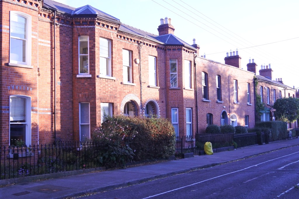
The North City Centre likely began seeing major development in the mid-17th Century with the development of the Smithfield Marketplace. The 1700s was a boom for North City as many members of the affluent Protestant Ascendancy class built Georgian flats in the district creating “Georgian Dublin”. The best remaining concentrations of this architecture is located along O’Connell St east to approximately Gariner Street Lower, surrounding Mount Joy Square Park. Even a pocket remains along Henrietta St. The wealthy, however, began to leave the North City in the early 19th century moving to new districts around St. Stephan’s Green and Merrion Square to the south. Many of the regal Georgian flats were converted into poor tenant housing. This trend deepened in the 19th century as Dublin as a whole became more impoverished thanks to the British Unification, which moved Dublin political power to Westminster and led to tariffs and other limits on Dublin’s wool linen trade. North City became even more impoverished and dense in the 19th century with a large influx of potatoes famine refugees from the country side in the mid-century. Even up to this day the North City  is viewed as Dublin’s ‘rough’ and rundown part of town compared to the upscale southeast side.

North City Center is a pretty loose neighborhood name for several subdistricts and loosely defined neighborhoods. The more defined subdistricts include: Smithfield, Liberty Corner, Mountjoy, and Summerhill.  I view the boundaries of North City Center to be Constitution Hill and Dorset Street (N 1) running northeast to the Grand Canal as the northern border, Stoneybatter to the west, and the Docklands/Grand Canal forming the eastern border. North City holds a very eclectic array of architecture styles and time periods ranging from the 1600s to the present day. There is so much texture and variety, great parks and landmarks to the North City that I find it an even more interesting urban district than Center City. Much of North City was redeveloped in the mid century with large school social housing schemes perceived as the answer to this district’s poverty and poorly built housing. Fortunately much of the old city fabric remains and the new and the old mix quite nicely without major scares to the urban fabric. The Smithfield market was completed made over in the 2000s replacing a historic market with a well designed urban plaza and shopping area.

O’Connell Street Lower is the heart of North City, a bustling mixed-use historic blvd/streetcar hosting the massive Spire, Parnell Statue, and the start of Easter Bombing in 1916 with the bombing of the several bldgs on the street. Henry/Earl/Talbout/Mary street is a narrow bustling pedestrian shopping street that cuts through east to west blocks in the North City.  Several pedestrian or semi-pedestrian block streets filled with retail businesses run perpendicular to Henry/Earl/Talbout/Mary street and three large shopping malls all feed into the main pedestrian street. Capel St is a wonderful historic mixed-use street running north to south. Other solid urban biz districts Parnell St, Dorset/Bolton/King, Smithfield St, Middle and Abbey/ Abbey St. Lower.

Click here to view my North City Centre Album and here to view my Smithfield Album on Flickr

URBAN STRENGTHS:

* Great mixed-use fabric throughout most of the North City supplemented by several great urban business districts and pedestrian shopping streets.
* Excellent cultural and retail amenities rivaling and sometimes beating these amenities in the Center City. Tons of restaurants, bars, live music venues, theaters, and several theaters. North City also hosts the best concentration of clothing and department stores centered along or near the Henry/Earl/Talbout/Mary Pedestrian Mall. Three of Dublin’s five city centre shopping centers are located here (i.e. Jervis Centre, the Ilac Shopping Centre / Moore Street Mall, & the Irish Life Shopping Mall).
* Northside hosts Ireland’s largest cinman (i.e. The Cineworld) and the Savoy Cinema one of Ireland’s oldest cinemas.
* Very eclectic and interesting mixed of architectural styles, development periods, and uses mixing in close proximity of each other.
* Very dense population which helps support all the retail districts.
* Great proximity to Center City sitting just south across the Liffey River.
* Great system of bike lanes (often projected) and the City’s best access to streetcar lines with better service than Center city.

URBAN WEAKNESSES:

* North City can be gritty at times and much of the mid-century in-fill is unattractive. Generally mid- century infill still has better urban design than its American counterpart.
* Much of the modern in-fill, while not always aesthetically attractive, is well designed from an urban form and design perspective.

Stoneybatter- a Historic Dublin Thorofare now a Hip and Gentrifying District close to the Center City

Long before Dublin extended much beyond Center City Stoneybatter was nothing more than a country road and served as a great thoroughfare to Dublin from the districts lying west and north-west of the city. The name Stoneybatter is the “English” equivalent of “the road of the stones”. In recent years the neighborhood has experienced pretty intense gentrification thanks to its increase in popularity and proximity to the Center City. It is often referred to as Dublin’s “hipster quarter”.

The northern half of the neighborhood is mostly 1-2 story stripped down worker housing similar to the Liberties district but a slight cut above. New mid-century rowhouses fil the south western quadrant of the district and the couple blocks closest to the river are a hodgepodge of turn of the 18th century, mixed-use fabric and institutional uses like the Collins Barracks, Criminal Courts of Justice, and Croppies Acres Memorial Park. Blackhall Place/Manor St. is an excellent business district  running along its eastern edge filled with many restaurants, bars, live music venues, and trendy shops. Also a decent commercial node along Benburg/Parkgate near the Liffey River. Very nice terrace housing along Circular Rd, which forms Stoneybatter’s eastern boundary.

Overall Stoneybatter is an attractive compact urban district with most retail and cultural amenities within a 10 minute walk. The neighborhood also has decent streetcar access (along its southern border), several dedicated bike lanes fill the main thorofares, and great park access thanks to Dublin’s largest park Phoenix park sitting on Stoneybatter’s western border. Stoneybatter’s biggest urban challenges is poor connectivity in spots thanks to the impenetrable Arbor Hill Cemetery and other likewise institutions, mediocre tree canopy, and middle of the road historic architecture.

Click here to view my Stoneybatter album on my Flickr Page

URBAN STRENGTHS:

* Generally pretty compact development and good walkable access to solid retail and food & beverage amenities and several museums (Arbor Hill Cemetery, Collins Barrack, Nat. Museum of Ireland Decorative Art, and several others).
* Dedicated bike lanes surround the district along the main thoroughfares.
* Great park amenities thanks to the Arbor Hill Cemetery, Croppies Acre Memorial Park, O’ Devany Gardens, and Dublin’s largest park (Phoenix Park) on its western border.
* Access to one streetcar line on the Stoney batter’s southern border.
* Good access to Center City but about a 20-30 minute walk. The Liberties and North City are adjacent to Stoneybatter, which are great neighborhoods themselves.
* Much less tourism here than the Center City. Most tourist in the district don’t venture beyond the Collins Barrack.

URBAN WEAKNESSES:

* Connectivity isn’t great especially with the impenetrable Arbor Hill Cemetery boundaries and the newer development in the SW part of the district.
* Limited urban infill.
* Some nice historic terraces along the Circular Rd (the western border) but most architecture is more stripped down late 19th century housing.
* Tree canopy isn’t great.

Portobello- Historic 19th century district home to many Middle Class Families and Dublin’s largest Jewish Communit

Portobello came into existence as a small suburb south of the City in the 18th century, centered on Richmond Street (R 114). During the 19th century Portobello was filled in with development transforming an area of private estates and farmland into solid Victorian red-bricked living quarters for the middle classes on the larger streets, and terraced housing generally closer to the canal for the working classes. The vast majority of development came in the  latter half of the 19th century. Portobello became the perfect transition neighborhood of the working class poor living in “the Liberties” to the west and the regal well off Georgian district to the east. Many mobile middle class families historically settled here. Portobello also became a major Ashkenazi Jewish community, fleeing widespread violence against Jews in Russia and Eastern Europe. This led to Portobello being known as Dublin’s “Little Jerusalem”.

Portobello is one of my favorite Dublin neighborhoods as it hosts a very comfortable and walkable urban district on the edge of the Center City. The architecture is an attractive mix of more regal upper middle class housing and worker rowhouses with just enough ornamentation to make them attractive. The R137 and Richmond Street commercial districts sandwich the neighborhood on the western and eastern sides providing excelling retail and cultural amenities (i.e. restaurants, bars, and live music). Portobello is also a 10-20 minute walk from most sites in the Center City but removed enough to not be overrun by tourists. Not much to complain about here from an urban perspective. The district has better tree canopy than most inner city Portobello districts and hosts a nice canal front walking path along the Grand Canal. The district could use more park and plazas spaces but not sure where they could squeeze this in as the neighborhood is very compact.

Click here to view my Portobello album on my Flickr page

URBAN STRENGTHS:

* Very well preserved historic stock mixing in more ornate with mostly stripped done rowhouses but with some minor ornamentation.
* Served by two vibrant commercial districts on the western and eastern edges ( R 137 and Richmond St),. Richmond Street (R 114) has excellent historic commercial architecture.
* Good tree canopy for Dublin standards and much better than the neighboring Liberties District.
* Excellent retail and solid cultural amenities, especially restaurants, bars, and live music. Very close to all the cultural amenities in Center City as it surrounds Portobello on two sides.
* District isn’t swarming with tourists.
* Urban modern in-fill, while limited is of a good quality.
* Good bike lanes network and close to a street ca line.

URBAN WEAKNESSES:

* Park space is limited to two  small squares and the recreational trail along the Grand Canal.

“The Liberties”- Dublin’s Historically Revolutionary Neighborhood and Home of the Guinness Blockhouse.

The name “Liberties” derives from jurisdictions dating from the arrival of the Anglo-Normans in the 12th century. They were lands united to the Dublin, but still preserving various rights and directly rule. This autonomy lasted all the way to 1840.  Settlement in mass started In the late 1600s where French Huguenots weavers settled. The neighborhood was actually pretty prosperous for a time but this came to a halt thanks to the neighborhood’s strong participation in the Irish rebellions of 1798 and 1803 and the ensuing Act of Union, which let to major tariffs on any silk products produced in the Liberties. From this time on, the fate of the Liberties was sealed and the district quickly became poverty-stricken with many urban ills. But the Liberties continued to be a hot bed of revolutionary activity.

Many parts of the Liberties have been torn down and redeveloped as part of mid-century slum clearance efforts by the government. But much of  the neighborhood remains in tact helping one imagine the working class grid that underpinned the district. But for the most part the Liberties is no longer a neighborhood for the destitute but has actually seen quite a lot of revitalization and even recent in-fill development. Many new crafting distilling and breweries companies have opened building on the neighborhood’s rich history with the Guinness Blockhouse. 

The Liberties also supports a pretty high level of urbanity with compact rowhouse development mixing with many mixed-use streets. Urban commercial districts in the Liberties include , R110, Meath St, Francis St,  R 137, and R 810 running along the entire length of the north edge of the district serving as the main route for Guinness visitors traveling to the Center City. The district also boosts one of Dublin’s longest running markets (Liberty Market), which feels more like a large flee market.  I’d certainly like to see more greenery and trees in the district but not sure where they would good. Same issue with inserting a quality waterfront park, the space simply doesn’t exist without a major redesign of the river.

Click here to view my Liberties album on Flickr

URBAN STRENGTHS:

* Highly walkable compact urban fabric.
* Excellent business district running across the Northern edge of the district on route R 810. Wonderful historic bldgs and eclectic businesses here.  Several other business districts as well, especially on the edge touching Center City.
* Lots of solid urban infill especially at the north and southern boundaries of the neighborhood and along the R110 business district.
* Thanks to all this mixed-use fabric, excellent retail and cultural amenities throughout the district, especially the eastern half.
* Great access to the Center City.
* With the exception of the Guinness Tours, not a neighborhood crawling with tourist.
* Good access to a rail line and solid bike infrastructure.

URBAN WEAKNESSES:

* Definitively one of Dublin’s gritter districts given its historic working class and slum history. But the neighborhood has received significant investment over the past several decades and by most measures is a good place to reside.
* Historic architecture is general plain and unadorned but at times interesting (especially the 1-2 story wide but shallow rowhouses).
* Very few trees
* Park space a bit limited but seems to be getting better with Bridgefoot Street Park. No real waterfront park or rec trail along the Liffey. Just a sidewalk.
* Some industrial uses still exist along the river.

Center City Dublin

Center City is really characterized by three separate subdistricts: Temple Bar running along the Liffey River, Georgian Dublin south of Trinity College spreading south and east to the canals, Trinity College, and the more “unlabeled” part of Center City between Temple Bar and Portobello.

Temple Bar is characterized by excellent narrow streets running between the river and R 137, an excellent mixed-use historic street. Temple Bar is the most touristy part of Dublin filled with bars, restaurants, live music and plenty of tourist traps. But it is quiet charming with its coble stone streets and 18th century and 19th century buildings.

Georgian Dublin:  This occupies a large part of Central Dublin extending south from Trinity College all the way south and east to the canal and westward to Aungier St. The district contains some of the best urban fabric of all of Dublin with consistent 3-5 story early 19th century flat Georgian architecture. The premiere park in the district is Stephen’s Square. But there are several other lovely squares (i.e. Merrion Square Park, Fitzwilliam Sq, Wilton Park, and Iveagh Gardens).  The most regal Georgian flats surround the squares or are along Harcourt St. Several excellent business districts cut through the district including Leeson Street Lower, Bagget Street Lower, Camden Street, R138, Pembrooke St, and Dawson St.

Trinity College/Center City: Trinity College is located just east of Temple Bar and is a gorgeous campus with many historic gothic buildings from the late 18th to 19th century.  North of here is a non-descript district mixing historic Georgian architecture and a lot of mixed-use in-fill spilling over from the Docklands. The area between Temple Bar south to Kevin Street and west to Patrick Street is the core of Center City Dublin. This includes some of the most important Dublin landmarks (i.e. St. Patrick’s Cathedral, Christ Cathedral, Dublin Castle, St. Audoen’s Church, Dublin Linn Garden, George’s Street Arcade, and Stephen Green’s Shopping Centre). The City’s best pedestrian mall/shopping district is also here along Kings Street/Clarendon Row/Grafton St/Wicklow Street. William/St. Andrea’s Street is a wonderful semi-pedestrian street nearby. R 137 is a solid business district that forms the Center City’s northern and western border with Temple Bar and the Liberties, respectively. Augier St is a wonderful business district with tons of gorgeous mixed-use architecture running north-south through the district and hosting George’s Arcade.

Click to the right to view several of my Center City Dublin Albums on Flickr: Center City, Temple Bar, and Georgian Dublin

URBAN STRENGTHS:

* Great dedicated bike lane system, many of them being separated.
* Highly walkable, mixed-use fabric with many business districts, landmarks, squares, and pedestrian street with excellent shopping options.
* Excellent cultural amenities including tons of restaurants, bars, numerous art galleries, plenty of museums and historic sites, tons of live music venues in Temple Bar, and several performing art and movie theaters.
* Lot of gorgeous historic architecture especially in the Temple Bar and Georgian subdistricts. Wonderful historic commercial buildings along Kings Street, Clarendon, Grafton, William St, Dame St, and Augier St.
* Several excellent urban plazas and squares.

URBAN WEAKNESSES:

* Fair amount of ugly post WWII buildings in Center City between Temple Bar and Portobello.
* Tree Canopy is limited to the squares and plazas.
* Connectivity and imaginability are a bit challenging with all the winding and dead-end streets.
* Disappointing access to the river in Center City. Just a simple sidewalk runs along the riverside.

Dublin’s Docklands Neighborhood- the City’s Internationa Finance Centre set in a Quality Urban Environment

The Docklands/North Wall started to take shape in the 1990s and has continued to grow and expand since.  The Docklands is a revitalization of Dublin’s historic port and has become the City’s premiere business hub and International Financial Services Centre. I like the urban and public realm design of the South Strand are better than the North Wall district. Developers seem to have built the North Wall with limited thought to the pedestrian experience and creating quality public places. The Docklands neighborhood in general has done a good job creating quality waterfront trails and recreational spaces on both sides of the Liffey along the Hanover Quay and canals. The Roya Canal Linear Park is the best designed public park.

The Docklands also hosts many neighborhood amenities including  several grocery stores & drugstores and other essential stores. Plenty of entertainment options here as well (i.e. theaters, live music, cineplex, bars, restaurants, and nightclubs). Docklands, however, lacks the boutique stores more common in the Center City and hosts few museums or art galleries. This is a place designed well for the young professional and perhaps some empty nesters looking to feel young but certainly not a very family friendly neighborhood.

Click here to view my Docklands Album on Flickr

URBAN STRENGTHS:

* Great waterfront parks and recreational trails here along Liffey, Hanover Quay and the canal).
* Decent public plaza space (i.e. Royal Canal Linear Park, Pearse Square, Elizabeth O’Farrell Park, Central Square).
* Some of the cities most cutting edge modern architecture is located here. Also some stunning bridges crossing the Liffey.
* Infill generally is designed to a high urban form.
* Excellent dedicated bike lanes along the waterfront and on the bridges.
* Comfortable pedestrian environment with wide sidewalks and well designed streetscaping. Also well served by two streetcar lines.
* Solid retail amenities including plenty of groceries, drug stores, banks and other basic neighborhood amenities.
* Several theaters, a cineplex and plenty of restaurants and bars. Also several live music venues as well.
* Hosts the Dublin Convention Center.

URBAN WEAKNESSES:

* Almost all of the historic docklands fabric has been erased. What does remain is in the western edge of the district but this is quickly be replaced.
* Some of the earlier in-fill (90s and 2000s) is rather bland.
* Tree canopy is a bit limited.
* Lacks boutiques, bookstores, clothing stores, and gift shops. Those are located further west in the Center City.
* Really no museums or art galleries here.