Sheraden- A westside urban district with convenient access to Dwtn Pittsburgh

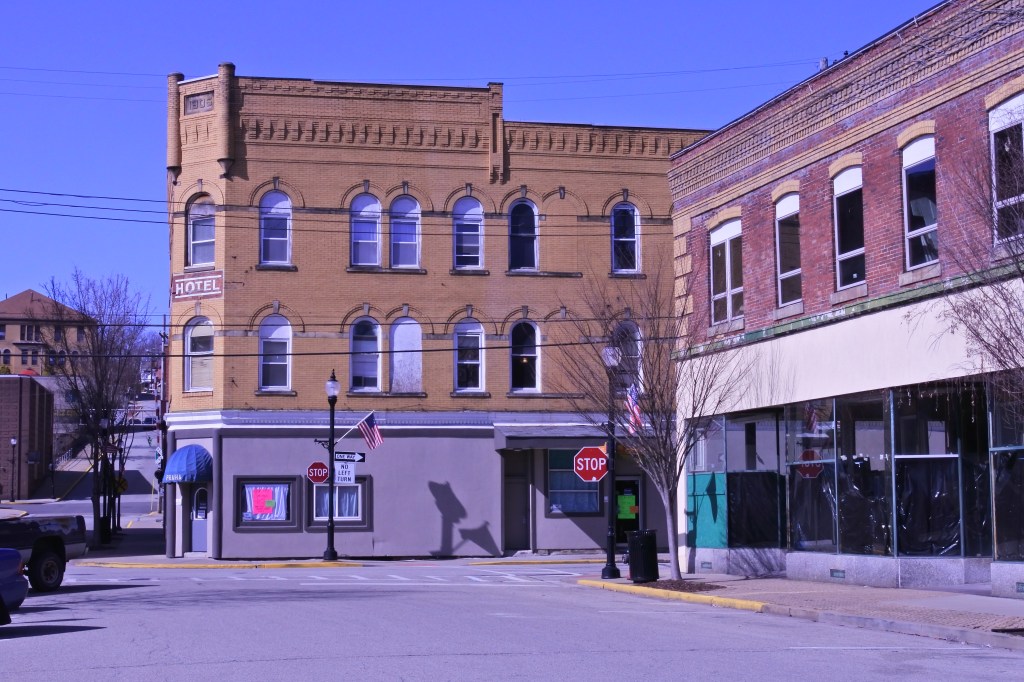
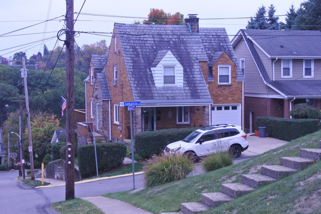
Originally incorporated as Sheraden Borough in 1894, Sheridan quickly grew and was annexed by the City of Pittsburgh in 1907. The neighborhood became a hub for Irish and German immigrants in the early 20th century. Like most European Ethnic groups most families moved to the suburbs in the 70s on the westside leaving a large African American population behind. 

Sheraden has struggled ever since shedding at least several thousand residents leading to many pockets of blight and disinvestment. The commercial districts along Chartiers and the Sheraden and Hillsboro node also suffered as well leaving a handful of bars and restaurants, a dollar store, and several convenience stores. Yet with the rise in interest and values in Pittsburgh since the 2000s, Sheradan has begun to slowly rebound, most visibly with a rise in price of its attractive turn of the century housing stock now selling in the high 100s and low 200s. There are also several pockets of stable 1950s housing in the Corliss sub district on the hill tops. With a great central park (Sheraden Park), busway access, and downtown only 3.5 miles away, I’m confident the neighborhood will stabilize and hopefully revitalize a couple nice urban business nodes. The speed of this work ready depends on how serious the City of Pittsburgh is about revitalizing its blight. 
Click here to view my Sheraden page on Flickr

URBAN STRENGTHS:

* Solid public transit access, especially with the West Bus Way running through the neighborhood.
* Great access to Dwtn via public transit and driving. Access to Oakland a bit challenging via public transit.
* Good racially diversity with a surprisingly large Asian population. Large Pct of family households and good age diversity.
* Large range in housing prices from 25K-the low 200KS depends on condition, size, and amount of blight in a particular section of the neighborhood.
* Sheraden Park is a large and amenity rich park located at the heart of the neighborhood. Several other nice smaller parks throughout.
* Pretty good historic architecture especially in the nicer streets of Sheridan.
* Decent tree cover on the residential streets, excellent along the hill sides and hollers.

URBAN WEAKNESSES:

* Density is pretty low but better than other Westside neighborhoods.
* Sidewalks are generally pretty consistant but ADA curbs missing in most intersections. Also plenty of sidewalks are not in great condition.
* Very high poverty rate (around 36%) but still decant economic diversity.
* Rental product (at least officially listed) is very low here.
* Retail and cultural amenities are limited to a couple restaurants & bars, a dollar general and several convenience stores. Downtown McKees Rocks has some good amenities a mile away though.
* Crime doesn’t appear to be a more issue here, but still a fair amount of blight.
* One elementary school located is the community is fair at best. A Middle school with a stem focus is located in adjacent Crafton Heights.
* Limited modern in-fill but at least there are some stable 1940-1950 homes on the hillside portions of the neighborhood.
* Decent urban form at the small biz node of Sheraden and Hillsboro. Chartiers is a tired early 20th century mixed-use Pittsburgh run with some good urban form but few open businesses.
* The streetscape is pretty underinvested and has been touched in decades.
* Pedestrian activity is fair at best.

West End/Elliot- West Pittsburgh’s most urban neighborhoods

West End Village (originally named Temperanceville) was founded in 1860 as a dry town. It was annexed into the City of Pittsburgh in 1874. The village was founded on the valley floor through which Saw Mill Run flows toward the Ohio River and between the Coal Hill end of Mt. Washington and River Hill. This is a very curious spot hidden in what I would call a Pittsburgh “holler” yet only 2 miles from Downtown Pittsburgh. It also is located in a flood plain. This along with being a victim of blight and abandonment have nearly decimated the village’s historically high population of 2,000 residents in 1940. Now just over 200 souls remain here. Fortunately, much of the neighborhood’s historic commercial remains in-tact forming a decent main street. Some businesses have set up shop here but much vacancy still remains.

Just up the hill from the West End westwards along the Ohio River is the Elliot Neighborhood. It was annexed into the City of Pittsburgh in the early 20th century. The neighborhood grew rapidly in the early 20th century  due to its proximity to downtown Pittsburgh and direct access to several arterial roads and streetcar lines into a pretty dense and walkable community. Sadly like many districts in Pittsburgh, it faced decline following WWII and has never really recovered. But unlike other distressed Pittsburgh communities, Elliott’s housing stock is mostly in-tact and boasts high densities, albeit without the walkable amenities it used to have.

Given their very convenient access to Downtown via transit and of course driving, there’s no reason these two urban communities should remain stagnant. Hopefully the City of Pittsburgh gets its act together in cleaning up the blight of these neighborhoods. Elliott could easily become a walkable community again with a decent mixed use district along Chartiers Ave. With appropriate investment the West End Business district could be thriving again but with dense housing surrounding it.
Click here for my West End Album and here for my Elliott Album

URBAN STRENGTHS:

* Excellent public transit access and very convenient to Dwtn and Oakland via bus and car.
* Very high level of family households and solid racial and economic diversity.
* Good park access with several small parks well dispersed in the community. Westend Overlook provides excellent views of Downtown.
* Excellent tree canopy due to all the hills and valleys.
* Good historic architecture in the West End biz district. The residential architecture is blander worker housing.
* Pretty good massing in the West End’s urban biz district.

URBAN WEAKNESSES:

* Decent bike connection into the West End via the West End bridge, but limited bike infrastructure outside of this.
* Housing is very cheap. High end of the market is in the low 100s. Fair amount of housing selling below 50K.
* Rentals are pretty limited and generally pretty cheap.
* Cultural amenities are limited but some good stuff including a local theater, a handful of restaurants and bars, a cafe, a couple art galleries. While not walkable the plethora of cultural amenities downtown and in the side are nearby.
*Some nice retail amenities (mostly in West End). This includes a post office, library, hardware store, a handful of boutiques, and lots of construction supply stores. No grocery or drug store nearby.
* While most structures are still standing  (esp. in Elliot) lots of vacancy and blight.
* No schools within the district and only a handful in nearby neighborhoods.
* Sidewalks are largely in tact but current ADA ramps is rare except in the core biz district of the Westend.
* Streetscaping is pretty uninspiring and outdated but not terrible.

Tarentum, PA- A well built but blighted rivertown 20 miles from Downtown Pittsburgh

Tarentum is located about 20 miles up the Allegheny River from Dwtn Pittsburgh. This rivertown developed after the Civil War, rapidly expanding in the late 19th century and reaching 5,400 residents in 1900. The borough peaked at nearly 10K souls in 1940. But like most Western PA river towns it has been on a steady population decline since WWII and now Tarentum has just over 4K residents.

Tarentum was a well built city and hosts a fairly expansive Dwtn with main street like buildings across several streets and several bulky historic mixed-use buildings (including a large abandonded Opera House). There is also a historic main street along Freeport in Western Tarentum that is largely in-tact but very blighted. Nice homes climb the hill north of Dwtn but most housing is historic worker housing. The oldest homes in Tarentum are near the Allegheny River, which also hosts a really nice riverfront park.

There is some hope for a revitalization of Tarentum. There is a small but dedicated group of local businesses downtown, many well built historic commercial buildings ripe for renovation and most of the housing stock is still in tact. It will be interesting to see if the slow drive of revitalization along 28 reaches Tarentum some day. 
Click here to view my Tarentum album on Flickr

URBAN STRENGTHS:

* Consistent sidewalks infrastructure, but modern ADA curbs are hit or miss. More within the biz districts.
* Some nice Dwtn Historic architecture. Mix of nice residential buildings (north of Dwtn) and gritty worker housing (West Tarentum).
* Lots of family households and decent economic diversity.
* Culturally Tarentum has a decent set of restaurants and bars, some live music venues,  a handful of cafes, a nice art gallery, a local museum.
* Crime is very low here but plenty of blight and abandonment. 
* Pretty good urban form remains in Dwtn Tarentum and even along Freeport in West Tarentum (although its a very gritty and underutilized biz district).

URBAN WEAKNESSES:

* No bike infrastructure.
* Transit access is so  but decent in the Dwtn Tarentum.
* Modern in-fill is limited. What does exist is mostly crummy autocentric uses.
* Rentals are very limited.
* For sale housing is inexpensive. Most product sells between 50K and low 100Ks. Some homes selling in the 100Ks but plenty below 50K.
* Tarentum has a very nice riverside park with multiple amenities but nothing else, meaning park space is not convenient to many of its residents.
* Some nice retail amenities downtown including a local pharmacy, family dollar, post office, a florist, a couple banks, jeweler, and several boutiques.
* Walkable schools limited to one public school.

Springdale, PA- Childhood home of Rachal Carson located only 25 mins from Downtown Pittsburgh

Springdale’s claim to fame is that it is the childhood home of marine biologist and author of Silent Spring, Rachael Carson. Perfect setting as Rachael Carson witnessed first hand the environmental destruction that modern industry can create on the environment and liked in the shadow of a very distinctive power generation plan with massive twin smokestacks. Other than this claim to fame, Springdale is yet another rivertown built on industry during the turn of the 20th century. Its population peaked in 1960 at 5,600 and has been in a steady decline ever since now hosting just over 3,000 residents.

Springdale is a relatively stable post-industrial town with a medium income near the Allegheny Co. average, limited poverty, and some blight (concentrated along its main street and near the Allegheny River). The main street hosts several nice in-tact blocks with a decent array of local businesses,. Beyond this Pittsburgh Street becomes pretty drab and semi-autocentric. It would be nice to see more businesses and in-fill along Pittsburgh St. and a renewed interest in Springdale. This might happen as some river towns along route 28 closer to Dwtn Pittsburgh have started to witness revitalization. If not, Springdale will likely continue on without much change.
Click here to view my Springdale Album on Flickr

URBAN STRENGTHS:

* Some nice historic architecture.
* While transit access isn’t great, only a 23 minute drive to Dwtn.
* Economically this is a very middle class community.
* High percentage of family households (56%)
* Crime below the national average, although there is some grit and vacancy especially Btwn Pittsburgh St and the River.
* Good tree canopy.
* Some local retail along Pittsburgh St but not a ton (i.e. dollar general, ice cream, a bookstore, jeweler, florist, post office, public library, and a couple banks and salons).
* The junior high and high school are walkable and located within Springdale Borough limits. A Christian school located in the adjacent Cheswick community.

URBAN WEAKNESSES:

* Sidewalks are consistent but really no ADA standard curb cuts.
* Modern in-fill is very limited.
* Transit access is so .
* No bike infrastructure.
* Pretty low density for an urbanized area.
* Relatively stable housing market, but not much variety in price point. For-sale generally ranges from 60K-180K depending on size and condition.
* Rental options are very limited.
* Park amenities limited to Veterans Memorial Field (home to several sports fields) and couple other greenspaces
* Cultural amenities limited to a handful of Americana restaurants, some bars, a local brewery, and the Rachael Carson Homestead Museum.
* Good urban form for several blocks along Pittsburgh St. but beyond this it becomes pretty semi-autocentric. Same idea follows for the streetscape.

Latrobe, PA- Childhood home of Mr. Rogers and Historic producer of Rolling Rock Beer.

Latrobe was founded in 1854 and quickly became a significant industrial hub due to its location along the Pennsylvania Railroad. Along with being the childhood of Mr. Rogers, Latrobe is famous for housing one of the largest breweries in the United States and the maker of Rolling Rock beer. Latrobe hit its population maximum in 1960 at 12K but is now down to just under 8K. This is actually a pretty manageable amount of decline for an old Pittsburgh steel town. Many are much worse off.

Latrobe has several nice blocks of in tact historic main street fabric along both Main St and Ligonier Ave. Certainly plenty of historic commercial buildings outside of this core area, but not great main street cohesion. Occupancy is spotty with some nice store fronts but plenty of vacancies or occupied 1st floor and vacant floors above.  Latrobe’s most stable housing market is east of Lincoln Ave where most homes sell well into the 100ks. The rest of Latrobe is mostly working housing selling between 50K and the low 100Ks.

To become a quality urban area again Latrobe should start with a Main St. revitalization focus reoccupying its storefronts and upper floors. This would certainly foster vibrancy and interest in the city. Other improvements include more walkable schools, better bike infrastructure, consistant ADA infrastructure, more rental options, and a hub for immigrants. Latrobe needs to more population and lacks diversity. With cheap housing, it is well poised to attract immigrants.
Click here to view my Latrobe album on Flickr

URBAN STRENGTHS:

* While there is certainly some blight in Latrobe crime is low.
* Very healthy medium income and a low poverty rate. High percentage of family households as well (nearly 60%).
* Solid park recreations well distributed throughout the borough.
* Decent walkable retail/neighborhood amenities including a Shop’n’Save, drug store, a library, post office, bakery, a dollar general, several boutiques, toystore, and a hospital.
* Some very nice historic architecture along Main St. and larger early 20th century historic homes on the east side of town.
* Decent urban form along Main St. for a couple blocks but it quickly breaks down to a semi-autocentric form. Ligonier also has a couple good blocks but then transitions into a gritty mixed-use street.

URBAN WEAKNESSES:

* Pretty poor density for an urban area.
* Generally consistent sidewalks and curb cuts but few ADA standard infrastructure.
* Limited bike infrastructure but a very nice recreational trail along the Lincoln and short path along the river.
* This a very white community (~96%) with limited racial diversity.
* Homes are very affordable but a stable market. Most homes sell between 50-200K. Some large mansions selling between 200K-300K.
* Rentals are very affordable but also limited.
* Cultural amenities limited to a handful of restaurants, bars, cafes, the Latrobe historic society, the Latrobe Art Center, and a couple other small art galleries.
* Walkable schools are limited to a public elementary, Catholic school and community college. The middle and high school are located out on the edges of Latrobe.

Mt. Oliver, PA Pittsburgh’s most Urban Suburb

The borough is surrounded entirely by the city of Pittsburgh, having resisted annexations by the City. I equate the urban form and level of blight and disinvestment with Mt. Oliver to be very similar to its neighbor, Knoxville, part of the City of Pittsburgh. This is a streetcar suburb that developed in the turn of the century maxing out at 7,000 people in 1930. Currently just over 3,000 residents remain in Mt. Oliver, but the Borough still retains pretty good density and quality urban form along Brownsville Road.

But similar to Knoxville, Mt. Oliver is plagued with disinvestment and shuttered stormfronts. They both share the same main street along Brownsville Rd. Residential streets, while at similar price points to Knoxville, are more in tact and stable than Knoxville overall. Mt. Oliver has great potential to become a viable walkable urban neighborhood with concerted reinvestment and attention. Other areas that could improve its livability include bike infrastructure, better park amenities, and new restaurants, retail, and creative storefronts along Brownsville road. A supermarket would be a huge benefit, but that may be down the road. There is at least a Shop’ n Save near the borough’s southern border. 
Click here to view the entire Mt. Oliver album on my Flickr Page

URBAN STRENGTHS:

* Consistent sidewalks throughout but current ADA infrastructure is absent from most residentials streets. Common along the commercial corridor, Brownsville Rd.
* Good tree canopy due to the terrain but limited street trees along the Brownsville Corridor.
* Convenient access to Dwtn via both driving and public transit.
* Good connectivity in the street grid.
* Great ethnically diversity in Mt. Oliver.
* While blighted, Brownsville is a pretty in tact urban businesses district with attractive architecture. Some attention was made the its streetscape several decades ago.
* Good density, especially for a Pittsburgh community that has seen significant disinvestment

URBAN WEAKNESSES:

* No bike infrastructure.
* Very high poverty here (around 35%) but a decent middle class population.
*  For Sale Market is still pretty depressed with most homes selling below 50K. Stable well maintained stocks transacting btwn 50K-160K. Decent rental product with a mix of cheap and middle market prices..
* Cultural amenities are pretty limited to a handful of restaurants &  bars. Most residents are still within walking distance to Warrington in Allentown which has many amenities.
* Retail amenities are a bit better including a public library, hardware store, post office, banks, a family dollar, drug store, and hair salons.
* Still safety issues in Mt. Oliver and a fair about of blight along Brownsville and residential pockets.
* An elementary school is within the Mt. Oliver boundaries. Middle and Highschool are not walkable.
* Urban in-fill is pretty limited.
* Park amenities include the medium sized Transverse Park and a cemetery. 

Bridgewater, PA Historic town at the Confluence of the Beaver and Ohio Rivers

This small borough is one of the oldest communities in Beaver County. By 1870 it had a population of just over 1,000. That population grew slowly until 1930 where it maxed out at 1,800. Now about 800 residents remain in the Borough. Yet due to its historic development, Bridgewater has some nice urban attributes including a small but vibrant urban biz district along Bridge St., some nice historic homes laid out on a street grid, and some quality recreational amenities. To improve it urbanity Bridgewater needs to fill in the gaps of its historic main street with some quality mixed-use infill and additional residential to increase its low density. Bridgewater Commons on the Borough’s southern tip where the Beaver and Ohio Rivers meet includes several multi-family buildings set within a quality new park. More projects like this would go a long way to making Bridgewater a quality urban town.

Click here to view my Bridgewater album on Flickr

URBAN STRENGTHS:

* This is a solid middle class community with only a 7% poverty rate and medium income slightly above the state average.
* Median age is pretty high but 50% of households are family households.
* Some blight throughout Bridgewater but pretty low crime rates in the past 5 years.
* Stable for sale market with most housing selling in the 100K. Some product above 200 and below 100K.
* Park amenities included Bridgewater Riverside Park complete with a waterfront trail and amphitheater and the new acre Bridgewater Crossing.
* Nice historic building including lots of architecture from the mid to late 1800s.
* Quality urban form on the northside of Bridge St but mostly parking lots on the southside. 

URBAN WEAKNESSES:

* While a lot of intersections have current ADA infrastructure, especially in the commercial district on Bridge St. sidewalks in the residential streets are hit or miss.
* Bridgewater has a country feel to it with its lack of infrastructure and low density.
* Bike infrastructure is limited to a  small disconnected all purpose path along the Beaver River.
* Racial diversity pretty limited. Over 92% White.
* Rental stock is pretty limited here, although the new Bridgewater Commons apartment complex should help with this.
* Cultural amenities include several nice restaurants and bars along Bridge St. Not much else although the quality cultural amenities of Beaver are nearby.
* In additional to restaurants and bars some nice stores along Bridge St including several boutiques and some neighborhood retail. No post office or library in the borough.
* No schools within the Bridgewater Borough limits but a catholic elementary just west of town in Beaver. Also several decent public schools within a 5-10 minute drive.

Connellsville, PA Historic Coke Capital of the World

Most of the City was included in my evaluation except the western and southern extremes south of Green St and west of 9th Street. Connellsville was officially founded as a township in 1793. By 1870 the town had more than 1,000 residents. Population got a boast in 1909, when balloting in New Haven and Connellsville merged the  two adjacent boroughs. New Haven was to the west of the Youghiogheny River and Connellsville to the east. Due to the city’s location in the center of the Connellsville Coalfield, coal mining, coke production became the City’s major sources of employment. Connellsville became known at the “Coke Capital of the World” due to the amount and quality of coke produced in its many beehive ovens. Connellsville also has the distinction of 5 railroads running through it. Many of these historic train stations remain. But like most Western Pennsylvania towns Connellsville has less than half of its historic population, which peaked in 1920 with just under 14,000 souls.

From an urban perspective Connellsville is well built but the scars of deindustrialization and poverty are highly visible. Historic main streets cover a large area along E Crawford Ave (historic Connellsville dwtn), W Crawford Ave (historic New Haven dwtn), Pittsburgh and Apple Streets. Lots of great buildings but only some of them have been stabilized. The Connellsville Redevelopment Authority has done some work to stabilize buildings and bring in new businesses. But there is certainly much more investment needed to make this a viable urban area once again. 
Click here to view my full Connellsville album on Flickr

URBAN STRENGTHS:

* Sidewalks are pretty consistent throughout the City. Also ADA curbs are pretty prevalent as well especially in commercial areas.
* Dedicated bike trail passes through the westside of town, part of the larger Great Allegheny Passage.
* Over 50% of households are family households and decent generational diversity in Connellsville.
* Several ballfield sprinkled through but other nice recreational spaces including the bike trail along the Youghiogheny River, the multi-faceted East Park complete with a lake, and a couple other smaller parks.
* Excellent but underinvested historic architecture especially in the historic dwtn. Residential architecture is hit or miss.
* Generally pretty good urban form even with missing teeth and vacant buildings. Several commercial streets spanning both sides of the river.
* Good array of retail throughout Connellsville several main street areas, but never great concentration in one area. Amenities include several drug stores, a public library and post office, a hardware store, nice array of antique stores, and some boutiques, banks, Highlands Hospital, and a full-service supermarket but in a strip mall plaza. 

URBAN WEAKNESSES:

* Poverty is pretty high topping 20%. This helps drive down medium income to just over 30K. Racial diversity is also limited as over 90% of the population is White.
* Limited rental housing. For sale housing is a bit better. Half of available housing goes for less than 50K. Still plenty of stable options selling from 75K-200K. Limited product in the 200Ks.
* Cultural amenities consist of several restaurants & bars (mostly Americana and Italian), the art community center (Appalachian Creativity Center), a community theater, and a couple local museums.
* Lots of blight and abandonment here and crime is higher than the Nat. average.
* Decent access to walkable schools with both the Catholic grade school and high school with the City limits. Connellsville public middle & high school are also located within town but located in the extra Northeastern corner in an auto centric part of town. 

Wilmerding, PA historic home of Westinghouse Air Brakes

This evaluation only includes the portion of Wilmerding south of Turtle Creek. That is the most cohesive portion of this small borough. George Westinghouse purchased current day Wilmerding in 1888 as the future site for his Westinghouse Air Brake Company and related facilities. The town quickly began to develop in the 1890s. Wilmerding’s most notable historic structure is the Westinghouse Air Brake Company General Office Building designed by local Pittsburgh architect Frederick J. Osterling.

Wilmerding feels very much like a villagy company town with two hubs. The Air Brake warehouse and factories along Turtle Creek and Wilmerding Town Square where the borough’s modest business district abuts. The town peaked with over 6,000 residents in 1920 and now barely boasts over 2,000. The fortunes of the town really seemed to decline by 1960. The Westinghouse Air Brake Company has gone through several owners through the decades but appears to still be producing train air brakes. To really find new life, Wilmerding needs to rebrand itself and find smaller manufacturing’s and businesses to move to the Borough. With investment in its main street and new retail this could be an attractive little town. Hopefully the conversion of the Westinghouse Historic Offices into a boutique hotel will breath new life and interest into Wilmerding. 
Click here to view my Wilmerding album on Flickr

URBAN STRENGTHS:

* Sidewalks are consistent throughout Wilmerding but current ADA curb ramps are rare.
* Wilmerding is only a 25 minute drive to dwtn but public transit options are fair.
* Younger than average population and near 50% are family households. Decent racial diversity.
* Westinghouse built some spectacular historic buildings here including the High School, Westinghouse Airbrake Building, and the Westinghouse historic offices. Residential architecture is pretty good as well.
* While the town has a fair amount of grit, especially in the commercial areas, it feels pretty safe.
* Solid tree canopy thanks to the hillsides that surround the borough’s border and consistent street trees. 

URBAN WEAKNESSES:

* No bike infrastructure.
* Poverty is around 25% driving down the town’s medium income to around 38K.
* Rentals are limited and inexpensive. Limited for sale diversity too with most homes selling below 50K. A few sales in the 100Ks.
* Walkable schools are limited but there is the Westinghouse Arts Academy for high schoolers.  This is at the site of the historic Wilmerding Memorial High School.
* Wilmerding Park is the only greenspace in the borough.
* Cultural amenities limited to only a handful of restaurants and bars. Hopefully the Westinghouse Air Brake Office Bldg.’s conversion into a boutique hotel will lead to some additional cultural amenities for the community.
* Some walkable neighborhood retail including a post office, dollar general, a portrait studio.
* There isn’t really a consistent main street, instead several blocks of main street like mixed-use buildings between Station St. and Wilmerding Park. These areas feel tired with little recent investment and TLC. Parts of it even have surface parking. 

West View, PA- once home to the Historic West View Amusement Park

This inner ring suburb, is located just north of the City of Pittsburgh. Interestingly, Westview is surrounded by Ross Township and the portion of the Township between West View and Pittsburgh is much newer. The borough likely developed along a streetcar line creating a historic leapfrog development pattern.

West View is similar to other Pittsburgh streetcar suburbs like Dormont, Mt. Lebanon, and Bellevue and has remained a stable and attractive community. The Borough’s population peaked in 1970 with 8,312 residents and now has around 6,500. Young families are attracted to West View due to its strong schools, convenient access to Downtown, and semi-walkability. Perry Hwy contains several in-tact urban commercial blocks, but many other parts of the Borough are pretty auto centric including the West Park Shopping Plaza built in the early 1980s to replace the historic West View Park Amusement Park. Other areas West View can improve include the addition of at least one street with dedicated bike lanes, better cultural amenities and parks, and more shops and occupancy along Perry Highway.  
Click here to view the full Westview album on my Flickr Page

URBAN STRENGTHS:

* Convenient access to dwtn and Oakland via the court. Ok transit access.
* Great generational and economic diversity here.
* Great array of for-sale housing options. Most housing is selling in the 100ks. Good amount. Decent amount of rentals as well medium priced.
* Attractive historic housing. Commercial district architecture is not that interesting.
* Some spots of quality urban business form and streetscaping along Perry and Center Ave.
* Good retail amenities including a supermarket, two drug store, post office, library, and a nice mix of specialty stores and general retail. But a mixed bag of whether stores are located on a walkable main street or strip mall.
* While some blight remains in Westview especially in the commercial corridors, this town has a very low crime rate.
* High quality elementary school located within the borough and is very walkable. Middle and High Schools are just outside of the borough’s border’s but unfortunately accessible on by car.
* High quality tree canopy aided by the hills and valleys of the borough. But a decent amount of street trees as well. 

URBAN WEAKNESSES:

* Sidewalks and ADA infrastructure is pretty good in the main street but hit or miss in the residential areas.
* No bike infrastructure in Westview.
* Very white community near 95%. Limited racial diversity.
* Decent but not great park amenities throughout Westview.
* Cultural amenities are limited to several restaurants and bars. Not much else here.
* In-fill architecture is mostly crummy strip mall buildings.