Scottdale, PA- the Historic Home of the H.C. Frick Coke Company sitting on the edge of the Laurel Highlands

The area witnessed an influx of Scotch-Irish immigrants in the late 1770s but it wasn’t until the construction of several branch lines through the community in the early 1870s that the settlement took off. The community was incorporated as Scottdale Borough in 1874 and by 1880 it had 1275 residents. The economy quickly transitioned from agriculture to manufacturing and mining and became the center of Henry Clay Frick’s coke interest where The H. C. Frick Coke Company was headquartered. But like many other rustbelt boomtowns in the area, Scottdale quickly declined starting in the 1930s when it reached a peak of 6700 residents. Scottdale now sits at 4,400 residents and the only major factory that remains is  Duraloy Technologies.

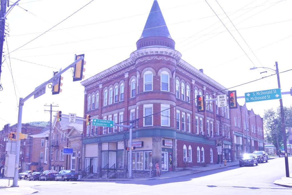
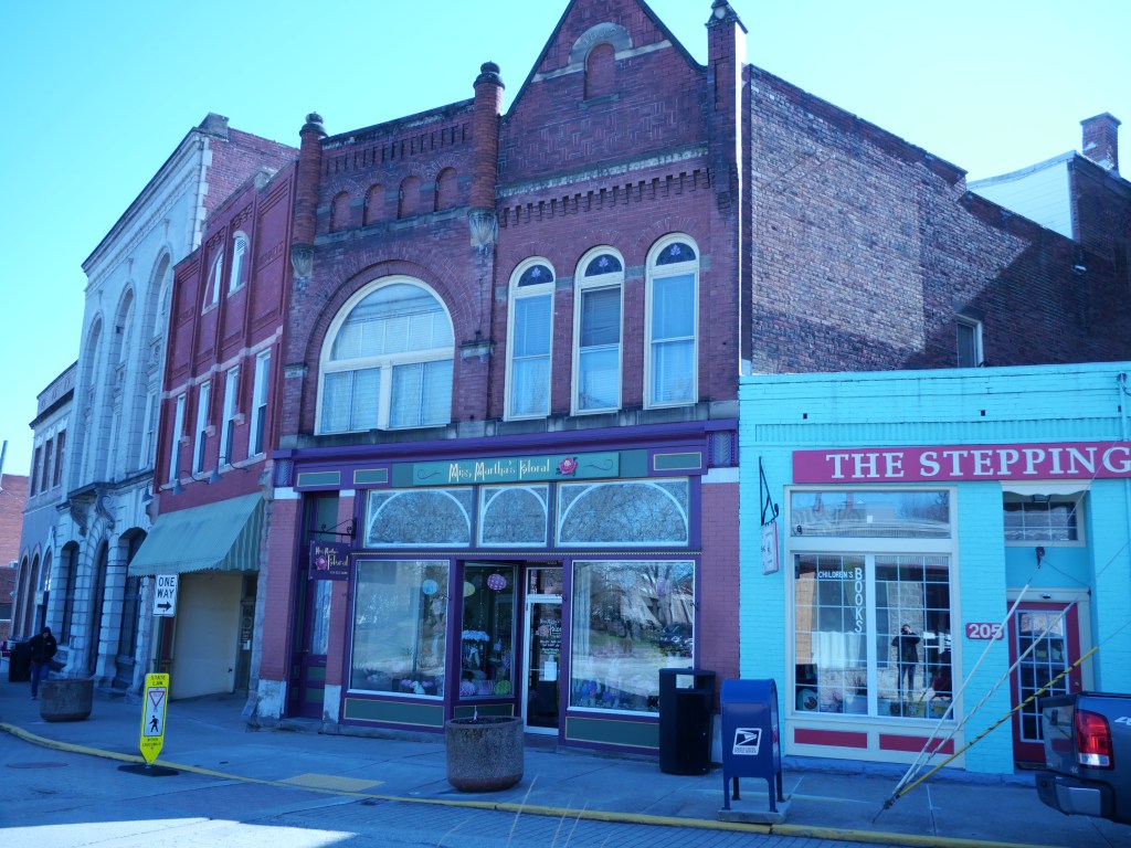
From an urban perspective Scottdale still retains a solid 2-block historic business district on Pittsburgh along with a semi-urban biz district running several blocks of Broadway. Even with its steep population decline Scottdale doesn’t have widespread vacancy and retains many attractive historic homes. The community is also safe and served well by many parks and decent retail amenities. Median household wealth runs about 55K, higher than many other rustbelt cities in the area.  I don’t see Scottdale urbanizing/densifying anytime soon unless the Borough encounters a major influx of immigrants. At best it can hope to remain course, which apparently there are signs it is succeeded at as the population was flat between 2010 and 2020.

Click here to view my Scottdale Album on Flickr

URBAN STRENGTHS:

* Sidewalk infrastructure is so so with about 1/3 of streets without sidewalks and about half of all intersections with ADA curb cuts.
* Public transit is pretty limited.
* 45 min drive to Dwtn Pitt (no transit access) and 25 min drive to Dwtn Greensburg, which is a small county seat job center. 40 minute transit trip.
* Good connectivity.
* Bike infrastructure in the City but nice recreational trail connecting the City to Mt. Pleasant (Coal & Coke Trail).
* Rental listings (at least listings) are very limited.
* Housing is very affordable but not a ton of variety. Larger 4 & 5 bedrooms top out at around 300K.
* Not much modern in-fill and what exist is generally autocentric crud along Broadway.
* Streetscape along Broadway and Pittsburgh is functional but warn and outdated.
* Some cultural amenities including several restaurants & bars, a couple cafes, a performing arts theater, a couple historic sites, 

URBAN WEAKNESSES:

* Sidewalk infrastructure is so so with about 1/3 of streets without sidewalks and about half of all intersections with ADA curb cuts.
* Public transit is pretty limited.
* 45 min drive to Dwtn Pitt (no transit access) and 25 min drive to Dwtn Greensburg, which is a small county seat job center. 40 minute transit trip.
* Good connectivity.
* Bike infrastructure in the City but nice recreational trail connecting the City to Mt. Pleasant (Coal & Coke Trail).
* Rental listings (at least listings) are very limited.
* Housing is very affordable but not a ton of variety. Larger 4 & 5 bedrooms top out at around 300K.
* Not much modern in-fill and what exist is generally autocentric crud along Broadway.
* Streetscape along Broadway and Pittsburgh is functional but warn and outdated.
* Some cultural amenities including several restaurants & bars, a couple cafes, a performing arts theater, a couple historic sites.

Mount Pleasant- a Pittsburgh Satellite suburb on the foothills of the Laural Highlands and Childhood Home to Henry Clay Frick

I only evaluated the core of Mount Pleasant as the residential streets towards the outskirts of the Borough start to become low density and often without sidewalk infrastructure. This is the area generally between Broad St to the north and Warden/Walnut Street to the south. I also didn’t include the eastern edge of Mt. Pleasant east of the railroad tracks.

Sparse settlement came to Mt. Pleasant around the American Revolutionary War. By the early 19th century Mt. Pleasant became a small village and grew into a borough in 1828. By the 1850s Mt. Pleasant had 500 residents. Glass manufacturing became the foundation of the local economy in the mid 19th century quickly followed by coke production thanks to the discovered of coal deposits in the area. Henry Frick, the town’s most famous resident, was born in a small village a couple miles outside of the Mt. Pleasant and spent many years working for his grandfather’s shop in the town  (the building still exists today). At a young age Frick began buying up coal land in the area in the 1870s and it was here that Frick began to build his coke business empire. Fueled by growing coke production and coal mining, Mt Pleasant blossomed to 5K by 1900. The Borough peaked at 6K residents in 1960 but has since been gradually declining and sits at 4K residents today. Many other steel towns in Westmoreland County have lost much more of their peak population and Mt. Pleasant fortunately remains very intact.

Mt. Pleasant has a mediocre urban center with a relatively in-tact main street with a good amount of remaining shops (especially furniture and antiques). Much of the historic 19th century architecture remains including lots of early-mid 1800 buildings and the town is served well by several parks and a pretty walkable fabric. But this is essentially a country town that still finds itself in the larger Pittsburgh Metro. Mt. Pleasant is an aging City with few immigrants and limited cultural amenities. Unless Mt. Pleasant somehow sees a major influx of immigrants, I don’t see it altering its slow declining course.

Click here to view my Mount Pleasant Album on Flickr

URBAN STRENGTHS:

* Good connectivity and gridded fabric.
* Best historic architecture is main street with some mid 19th century architecture mixed in but some good residential homes too.
* Good street connectivity.
* Overall a pretty safe community.
* Decent park amenities including the central Frick park and the more extensive Willow part on the edge of the core city. Also a couple cemeteries as well.
* Better retail amenities including a Shop n Save, and smaller locally owner grocer,  couple drug stores, a couple antique and boutiques, a larger Levin Furniture Store, a couple florist, a public library, a couple dessert joints and gyms, post office, plenty of churches, and a hospital just located south of the core city.

URBAN WEAKNESSES:

* About 70% of the streets in this evaluation area have sidewalks but often very narrow and 1/2 of them have modern ADA curb cuts.
* 45 min drive to Dwtn Pitt (no transit access) and 20 min drive to Dwtn Greensburg, which is a small county seat job center. 35 minute transit trip.
 Not much urban in-fill other than some autocentric crud.
* No bike infrastructure to speak of.
* Very low urban density
* Decent number of families but a very aging population. Median age is 52.
* Only the elementary school is located in the City core. High school is on the outskirts of town.
* Cultural amenities limited to a handful of restaurants & bars, a couple cafes, the Helltown Brewery, and a couple of historic homes & sites.
* Housing is very affordable but not a ton of variety. Larger 4 & 5 bedrooms top out at around 300K.
* Rental options (at least listed) are very limited as well but very affordable.

Somerset, PA- On the edge of the Laurel Highlands

In this review I included only the cohesive pre-WII part of Somerset. This account for about 60% of the Borough boundaries. Grand houses are concentrated along Main Street west and east of the center city.

Somerset is one of Western PA’s oldest communities and was a central stage for the Whiskey Rebellion of 1794. The Borough grew quickly in its early days reaching 500 by 1810, 1,000 by 1860, and 2,000 by 1900. Population peaked at 6,700 in 2000 thanks to the Borough incorporating much of the new suburban development.  Yet Somerset has lost population since due to an aging population and lack of immigrant. It now has just under 6K residents.

Downtown Somerset is centered at the cross roads of Main and Center Streets  but mixed use fabric expands a couple blocks from here. Somerset also hosts the county seat, which has likely kept the Borough from declining further. Grand homes line Main Street, both west and east of Downtown. Residential stock off of Main Street is more working class. and uninspiring. Much of the urban fabric in Downtown has been preserved but the commercial streets have become increasing auto centric a couple blocks from the cross roads of Main and Center Streets, especially at the interchange.

Somerset still has a decent amount of local retail, good connectivity, decent schools, inexpensive housing, and is a generally safe community. But nothing reality inspires me about Somerset from an urban point of view. Many of its downtown storefronts are vacant or underutilized, there are not bike paths, public transit is limited, parks are few, and there is really no new development occurring other than strip malls by the interchange. The community could really use a boast from immigration it help it stabilize its population and increase racial diversity.

Click here to view my Somerset Album on Flickr

URBAN STRENGTHS:

* Generally solid street connectivity.
* Consistant sidewalk infrastructure throughout Somerset but ADA curb cuts can mostly concentrated dwtn and along Main Street.
* Decent economic diversity. Decent # of households with children but Somerset like most older PA towns is aging overall.
* Good schools here but only the Catholic elementary and public high school are within walking distance of the center of Somerset.
* For sale housing is generally inexpensive but some diversity. Only a handful of 1-beds that sell for around 100K, 2-beds sell btwn 50K-150, 3 & 4 beds sell btwn 75K=350K but a handful of homes around 500K.
* Somerset is generally safe with not too much crime north is blight widespread.
* Pretty good retail amenities including a couple groceries (Giant Eagle on the outskirts), several drug stores and family dollars, a couple boutiques/gift stores, a hardware store, several clothing and consignment stores, many banks, several boutiques, several dessert joints , a couple gyms, lots of doctor offices and churches, a public library and local post office.
* Decent historic architecture esp. along Main Street and dwtn.
* Decent Tree canopy here.

URBAN WEAKNESSES:

* Poor Density for an urban area.
* Public transit is very limited here.
* Poor access to Dwtn Pittsburgh and job centers. Over a 1 hour drive.
* limited racial diversity, this a very White community.
* No bike infrastructure to speak of.
* Very few rentals listed on the open market. What is available is affordable.
* Many of Somerset’s park amenities are located on the outskirts where it isn’t walkable. Within the center city there is a couple of plazas and cemeteries.
* Okay cultural amenities including several restaurants & bars, a couple cafes & art galleries, the Guild of American Paper cutters Museum.
* Very little in fill to speak of except crummy commercial infill near the highway interchange.
* Good urban massing in the core of Dwtn Somerset but becomes more autocentric as the Center Ave and Pa-31 leave town especially near the highway interchange.

McDonald, PA- A small borough located on the Allegheny/Washington County Line

Like many small boroughs in Western Pennsylvania, McDonald was established in the late 1880s around light manufacturing. By 1900 the town hosted 2,400 residents and peaked at 3,500 in 1950s. Since then the population has declined by nearly half and just over 2,000 souls resident in McDonald.

While McDonald is in the Pittsburgh MSA, it feels pretty disconnected to the Pittsburgh Metro. There is no Port Authority Service here and its surrounded by woods and farmland. But McDonald is only a 1/2 hour drive to Downtown Pittsburgh. This is one of the less developed sides of the Pittsburgh Metro. From an urban perspective McDonald has stable housing, largely in-tact but gritty and often vacant commercial buildings. The community does have several important amenities including a Giant Eagle, a local library and post office, a handful of shops and restaurants, good parks, and overall a pretty safe community. The only way for this to become a thriving urban area is more people. But without a major wave of immigrants I don’t see McDonald changing much (other than continuing its slow decline) anytime soon.

Click here to view my album on Flickr

URBAN STRENGTHS:

* Decent connectivity.
* Excellent economic and generational diversity.
* Lots of affordable and moderately priced SF homes with prices ranging anywhere btwn 75K-335K
* Pretty good tree canopy.
* McDonald hosts a pair of medium sized parks (Heritage and East End Parks) with good recreational and sports amenities.
* Overall a pretty safe community.
* A set of very nice historic business buildings and pretty good historic homes as well.
* Good urban form in the core of Dwtn. But it drops off outside of the core and becomes pretty auto centric.

URBAN WEAKNESSES:

* Pretty low density for an urban center.
* Very limited public transit here.
* Driving to Dwtn and Oakland only takes about an hour but very limited public transit options.
* ADA compliant ramps is hit or miss. Sidewalks missing on about 1/3 of streets.
* Nice recreational bike trail cutting through town, but other than that no other bike amenities.
* Limited racial diversity as McDonald’s population is 90% White.
* Rental options are very limited.
* Several well rated schools are a 10-15 minute drive. But none of them are walkable.
* Cultural amenities are limited to a handful of restaurants & bars, a historic theater (now an event space), and the Calwell Historic Home (now an B&B).
* McDonald has some retail amenities including a Giant Eagle, a couple pharmacies, a couple banks, several salons/barber shops, a local post office, a couple antique and home good stores, a gym, a local public library, and several churches.
* Very limited modern in-fill and what does exist is generally crummy auto centric bldgs.