Shipoke- Small Historic Residential Enclove just South of Downtown Harrisburg

Shipoke was first settled by Europeans in 1710 as a small trading post before other areas of Harrisburg. Some of the oldest houses in Harrisburg line the narrow, winding streets of this compact, close-knit community. Shipoke is really what is left of Harrisburg’s Southend 19th century residential fabric that wasn’t swallowed up by Downtown, industrial development, or highway spurs. The neighborhood was in pretty rough shape in the 1970s after the extension of I-83 and flooding caused by Tropical Storm Agnes. But after many years of rehabilitation in the 80s and 90s, Shipoke has become a picturesque and affluent Harrisburg enclave located within walking distance of Downtown with gorgeous river views of the Susquehanna River.

From an urban perspective Shipoke is a mostly residential community with convenient access to cultural and retail amenities in Downtown Harrisburg located around 0.5 miles away. It also boast a nice array of moderate for sale options, good park amenities, and high levels of safety. For Shipoke to compete with Midtown as Harrisburg’ best urban district it needs an elementary school to make the district more attractive to families and more retail & cultural amenities located within the neighborhood.

Click here to view my Shipoke Album on Flickr

URBAN STRENGTHS:

* Sidewalk infrastructure is solid but because of the desire to keep the historic brick sidewalks there are few ADA standard curb cuts.
* Hard to get a solid population number by 1,000 residents seems about right get the district population to just shy of 15K per square mile.
* Excellent access to Dwtn Harrisburg being less than 1 mile to the core of Dwtn. Also convenient access across all modes of transit including a Capital Area Greenbelt bike path along the River.
* Solid racial diversity and ok economic diversity. This is def a higher end professional neighborhood.
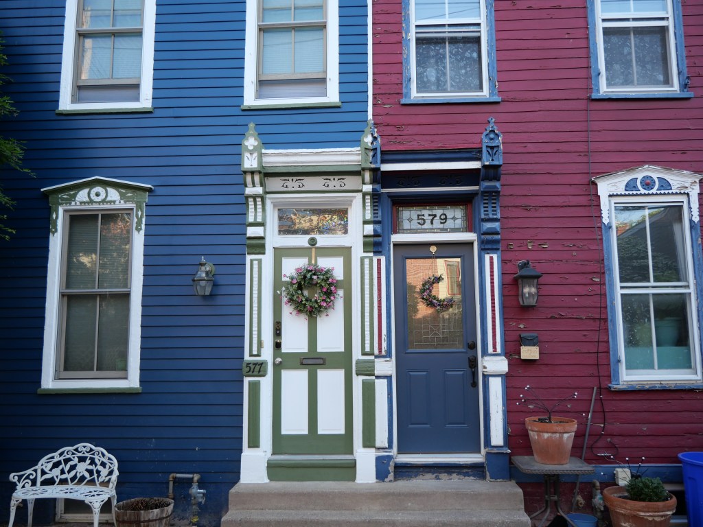
* Nice historic for sale housing stock at pretty moderate prices considering Shipoke’s proximity to Dwtn. 2-beds sell in the 200Ks and 3 & 4 beds btwn 150K-400K.
* Solid park amenities for such a small district including a playground park, riverfront park along the Susquehanna River and a greenspace along the highway. City Island is also only about 1 mile away.
* Overall a very safe community.
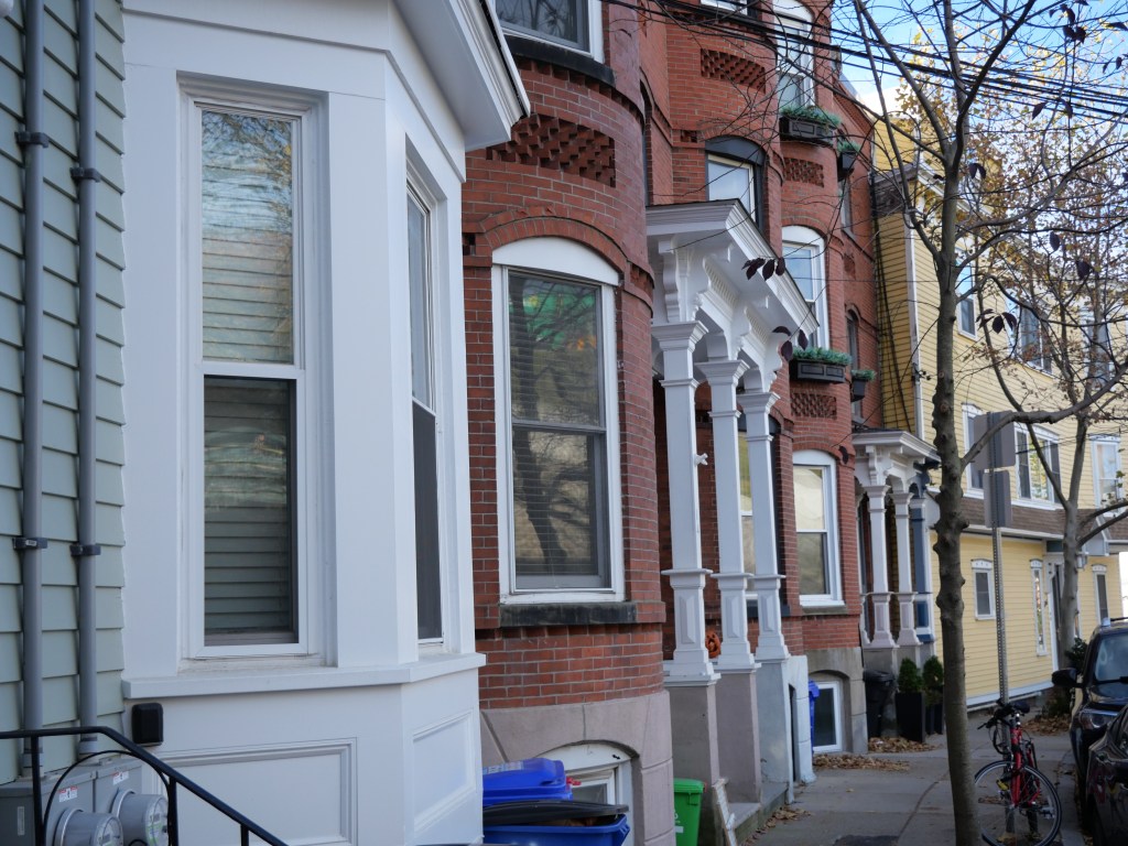
* Some of the best preserved mid-late 19th century rowhouse architecture in the City. In-fill is a mixed bag. Some nice historically sensitive in-fill and solid modern but urban infill. Also some unattractive post War buildings (e.g.  parking garages, hotels, etc.
* Generally good urban form in the district but more autocentric uses in the northern edge of Shipoke and some unattractive highways and stroads sit on the eastern edge of the district.

URBAN WEAKNESSES:

  • Several well rated specialty public high schools and private schools Dwtn but no schools located within Shipoke.
  • Lots of young professionals and empty nesters. Few family households.
  • Rentals are mostly limited to whole home renovations but a pretty reasonable prices.
  • As this a primarily small residential neighborhood other uses are very limited. Within Shipoke there is a nice bar & restaurant, a couple historic museums, UPMC Hospital, cafe & bakery, a eye doctor. However as Dwtn is 0.5-1 mile away many retail & cultural are still walkable within Dwtn.

South Allison Hill- Harrisburg’s Immigrant Community Slowly Emerging from Decades of Disinvestment

Allison Hill (also known as The Hill) was named after William Allison, an early Harrisburg landowner who owned farms on the bluff outside of the then-Borough. Allison Hill encompasses the Mount Pleasant Historic District located in the western half of the district including a diverse array of mostly rowhouse styles from the late 19th century. Allison Hill quickly transitioned into the booming industrial heart of the city in the late 19th century. Initially Allison Hill attracted immigrants from primarily European countries but this has diversified since the 70s to include a diverse melting pot with immigrant groups from West African, Vietnamese, Indonesian, several Latin American countries and a significant African-American population.  Following its decline since the 70s The Hill has also become a hot bed of  artists and social justice activists. Disinvestment in he community peaked in the early 1990s and the neighborhood has someone stabilized since then thanks largely to an influx of immigrant families. However, Allison Hill has never really gentrified and still contains a large number of vacant properties, contains a high level of families living in poverty, has a higher crime rate than most of Harrisburg and lacks crucial retail and cultural amenities.

Thanks to its dense late 19th century rowhouse fabric, South Allison Hill still has a lot of positive urban attributes despite several decades of disinvestment. The neighborhood has excellent public transit service, convenient access to dwtn, and very affordable housing. With some investment and increase in economic diversity South Allison Hill could become a premiere Harrisburg  urban district and boast density levels higher than even Midtown.

Click here to view my South Allison Hill District Flickr Album

URBAN STRENGTHS:

  • Some of the best public transit access in all of Harrisburg and only a 5-10 min trip to Dwtn about 1-1.5 miles away.
  • Sidewalks are consistent throughout the districts.
  • Solid Density esp. for a community that has seen a lot of disinvestment since the 1970s.
  • Decent poverty numbers at about 20% but also a good # of middle income households too. Large Hispanic and Black populations but limited White populations.
  • Good array of late 19th century rowhouse architecture but not well maintained like Uptown & Midtown.
  • The urban form of the biz districts (Market, 13th, 17th & Derry) actually isn’t that bad in South Allison Hill outside of several concentrations of vacant lots and underutilized land uses. Limited crummy autocentric uses and several good clusters of urban commercial blocks, albeit underinvested.
  • Decent rental availability with lots of affordable options. 1-beds lease btwn 800K-1.1K, 2-beds btwn 800K-1.3K, and plenty of 3-beds leasing in the low-mid 1Ks.
  • Decent retail amenities including a bank, plenty of small ethnic grocerias, a dollar store, a couple drug stores, a local bakery & cafe, tons of barbers and salons, a bike shop, a couple churches and a health center.

URBAN WEAKNESSES:

* Sidewalks while plentiful are also very dated as Allison Hill has not seen major streetscaping reinvestment. Only about 1/4 of all curb cuts have been updated.
* No dedicated bike infrastructure here.
* Parks are very limited in South Allision Hill but at least the expansive Reservoir Park is just outside of the neighborhood.
* Tree canopy is so so and very hit and miss.
* While crime is not off the charts here Allison Hill does hosts some of the most dangerous pockets of Harrisburg and has a lot of blighted and unkept bldgs. But there are strong community ties here esp. among the immigrant groups making it safer. Neighborhood still has a pretty negative perception among locals.
* Western and southern edges are very industrial with unattractive often autocentric uses.
* The only schools located within South Allison Hill are 3 public schools of mixed ratings located in the SE corner of the district.
* Decent for sale inventory but generally very inexpensive. A handful of 1-bed condos selling btwn 50K-100K, 2-beds btwn 50K-150K, 3 & 4 beds btwn 50K-250K. Decent amount of renovated product selling over 150K.
* Cultural amenities are limited to several  restaurants and bars along with a  brewery. Plenty of Dwtn cultural amenities located only about a mile away.

Fountain Square- One of Indianapolis’ trendiest Neighborhoods with plenty of room to grow

Fountain Square is located just southeast of the inner belt with the core of the neighborhood located where Prospect and Virginia Ave intersect. The neighborhood derives its name from the successive fountains that have been prominently featured at the intersection of Virginia Avenue, East Prospect Street, and Shelby Street. The neighborhood developed primarily by German-American immigrants who established a strong German character on the city’s southside. The ethnic mix diversified near the turn of the 20th century as Fountain Square saw an influx of many Eastern and Southern European immigrants. From the 1920s to the 1950s, Fountain Square was the City’s main entertainment district  with several theaters gracing its streets at one time, which is unusual as most city’s entertainment districts are located downtown or on the edge of it. Fountain Square hit a high point of 27K residents in 1950 but like most inner city Indianapolis neighborhoods it declined rapidly after WWII.  After decades of population decline, Fountain Squar lost almost 2/3s of its population and now has just under 10K residents. While the population has still not stabilized, Fountains Square’s revitalization efforts began in the 1980s with the creation of three designated national historic districts (Laurel and Prospect, State and Prospect, and the Virginia Avenue Districts). Serious revitalization efforts really got going in the 1990s focused on stabilizing the historic Commercial District of Fountain Square at Prospect and Virginia. This momentum has continued to the present day as reinvested commercial blocks continue to slowly expand down Prospect and Shelby Street and more and more residential streets stabilize with renovations and new construction. 

While Fountain Square is considered one of Indy’s trendiest neighborhoods and one of the City’s 7 cultural districts there is still a lot of stabilization needed here outside of the core blocks surrounding Virginia & Prospect and in the residential streets especially in the eastern half of the neighborhood.

Click here to view my Fountain Square album on Flickr

URBAN STRENGTHS:

* Convenient access to Dwtn being about 2-3 miles away from Fountain Square.
* Good dedicated bike lane system including an off road bike lane running along Virginia to the heart of Dwtn.
* Fountain Square has decent racial diversity at about 65% White and the rest a mix of Black & Hispanic families. Wide divergence in incomes between the more gentrified area in the heart of Fountain Square (closer to Dwtn) and along the edges of the district. Solid generation diversity with a good mix of family households and young professionals.
* Safety in Fountain Square has come a long way since the mid-90s when this was a pretty dangerous neighborhood. Overall the neighborhood is now pretty safe but some crime in pockets of the district likely along the less gentrified edges. Still a good amount of grit and vacant lots remain in these areas.
* Excellent concentration of attractive early 20th century commercial bldgs in the core of Fountain Square. The residential areas are a mix of more detailed homes that have been fixed up and underinvested working housing.
* Solid urban infill in the core of Fountain Square and generally good residential infill.
* Good park amenities including several small parks well distributed across the neighborhood, a couple medium sized parks, the Pleasant Run Trail running the southern edge of the district, and Willard Park, which is a good sized park just to the NE of Fountain Square with a public pool.
* Solid cultural amenities esp. a high concentration of restaurants, bars, cafes, night clubs, live music venues, & art galleries, concentrated at Fountain Square’s heart (Prospect & Viriginia). Limited food & beverage amenities outside of this core.
* Great urban form and esp. Streetscaping at Fountain Square’s heart (Prospect & Virginia).
*  Decent retail amenities mostly concentrated at Prospect & Virginia. This includes a Mexican Grocery Store, good array of boutiques & gift stores, tons of salons, a couple book stores, several dessert joints & bakeries, a couple gyms, a record store. several doctor’s offices and plenty of churches.
* Great array of rentals albeit on the pricier side. Studios lease in the low 1Ks, 1 & 2 beds lease anywhere from $850-2K, and a good # of 3-beds that lease btwn the high 1Ks-3K.
* Significant decent for-sale diversity with a good # of small 1 beds SF homes selling in the 100Ks, plenty of 2-beds selling anywhere from 150K-450K including a mix of condos and SF. 3 & 4 beds sell btwn 150K-750K

URBAN WEAKNESSES:

  • Quality Urban form quickly diminishes as you move away from Prospect & Virginia along Prospect and Shelby. The core of Fountain Square does appear to be slowly creeping down these corridors with quality urban infill. Pretty poor urban form & streetscaping along Prospect Park’s other Arterials (Washington & Southeastern). Lots of industrial uses along these streets.
  • At 5K residents per square mile this is a pretty low density for an urban neighborhood. Significant amount of vacant lots and underutilized commercial/industrial space remain in the neighborhood.
  • Decent access to walkable schools including several k-8 schools of mixed ratings and types.
  • Sidewalks infrastructure is good but not excellent. Less than half of all intersections at ADA standard.”

Fletcher Place- Inner city Indianpolis Neighborhood just SW of Mile Square

Fletcher Place is an inner city Indianapolis neighborhood located just southwest of Mile Square (downtown). The district was developed starting in the mid 19th century and was most filled in by the 1920s. Historically Fletcher Place  didn’t suffer the same wholesale disinvestment of other inner city neighborhoods but there was a fair amount of post WWII blight, urban renewal, and industrial development that have created grey zones on the edges of the district. Like other inner city district within the Innerbelt, Fletcher Place has seen significant reinvestment starting with the creation of the Fletcher Place Historic District in the 1980s and newer hip businesses sprouting up along Virginia Avenue within the last 10-15 years.

The biggest next step for making the Fletcher Place neighborhood whole again is the redevelopment of its western and north edges, which were ravaged by urban renewal, industrial development, and disinvestment. There are however some signs of life along the north edge with new apartment buildings spilling over from the Cole-Noble District. This would add density to an already medium density community helping add needed retail amenities and hopefully created enough school age children to build new walkable schools in the neighborhood. Fletcher Place also needs more parks and better tree canopy.

Click here to view my Fletcher Place album on Flickr

URBAN STRENGTHS:

* Decent density but a bit underwhelming for a district located adjacent to Dwtn.
* Solid overall sidewalk and ADA infrastructure but a decent amount of curbs are not up to ADA standards.
* Excellent access to Dwtn being 1 mile on average and accessible across all modes of transit. Decent bike infrastructure including two bike lanes that feed right into dwtn and a handful of bike share stations.
* Overall great racial diversity, solid economic diversity. Few families here however and the district is largely childless young professionals.
* Within Fletcher place there are solid good & bev amenities including a good array of restaurants, bars, cafes, & a couple breweries. One needs to go to adjacent district (dwtn, Fountain Square, & Lockerbie Square) for higher cultural amenities like museums, art galleries, live music, and theaters/cinemas.
* Overall a safe community.
* Significant decent for-sale diversity with a handful of 1 beds and decent # of 2-beds selling anywhere from 200K-500K including a mix of condos and SF. 3 & 4 beds sell btwn 250K-800K
* Good # of rentals  with studios & 1-beds leasing in the low-mid 1Ks, 2-beds generally in the mid-high 1Ks. 3-beds are very limited.
* Good amount of attractive historic homes tucked on the residential streets and some attractive historic commercial along Virginia Ave.
* Some good urban infill especially along Virginia and with new SF construction in the neighborhood.

URBAN WEAKNESSES:

  • Only a small Catholic school located within Fletcher Place but some decent schools in neighboring Fountain Square.
  • So so access to parks including a couple small & medium parks and Idle Park which is in the middle of the I-65-70 inner belt.
  • Good amount of urban renewal occurred along East St and the north 1/3 of Fletcher Place. Newer dense apartments are starting to improve the north edge but limited urban projects along East St. Still some holes to fill along Virginia Ave.
  • Decent tree canopy along the residential streets but pretty poor along East St and the North 1/3 of the district.
  • So so retail amenities within Fletcher Place including a Wholefoods located just north of the neighborhood, a couple banks, a handful of boutiques & gift stores, a handful of barber shops/salons, a local bakery, a handful of doctor’s offices nearby, and a couple churches. More walkable retail amenities in neighboring communities (dwtn, Fountain Square, and Lockerbie Square).”

Graview Heights & Marble Cliff, OH- Desirable Streetcar Suburbs located just Northwest of Downtown Columbus

Grandview is one of Columbus’ more attractive inner ring suburbs located just 2-3 to the northwest of downtown. I include all of Grandview in this evaluation except the random block between Star and Farview Avenue between 3rd and 5th Ave. This a simply included with in my evaluation of the Columbus neighborhood of Fifth by Northwest. Marble Cliff is also included in this evaluation as it is a very small independent community that acts as an appendage to Grandview.

Grandview Heights was developed in the early 20th as a classic streetcar suburb and contains quality early 20th century housing stock, leafy and sometimes curvy streets, mix of SF and smaller MF development, and a nice walkable urban district along Grandview Avenue. The recent Grandview Yards development has given more density and important destination restaurants and bars in a previously underutilized industrial area.

Marble Cliff was one of the first suburbs of Columbus settled as a community in 1890 and incorporated as the “Hamlet of Marble Cliff” in 1901. It took its name from the Marble Cliff Quarry Co. (still in use today). Marble Cliff detached all land but its present area and the area that separated became Grandview Heights in 1906. Marble Clif was first called  “Arlington” which led its new neighbor to the north to name itself Upper Arlington. Further adding to its association with Grandview Heights most of the village’s public services are provided by contract with Grandview Heights. Marble Cliff’s population has hovered between 600-700 since 1960 now has hosts housing from pretty much every decade of the 1900s. The Village has a pretty pouch and exclusive vibe but is still tied into a decent urban grid with decent sidewalk and ADA curb infrastructure.

Given the communities close proximity to Dwtn Columbus and the continued growth and development pressures of the Columbus Metro, these communities need to continue to urbanize and allow for more housing. This is especially true along the main arterial through the communities (5th Avenue).

Click here to view my Grandview Heights and Marble Cliff Albums on Flickr

URBAN STRENGTHS:

* Quality urban commercial district along Grandview Avenue filled with walkable restaurants, bars, coffee houses, and local retailers.
* very in-tact and well kept early 20th century architecture (mix of wood frame and brick). 
* Major mix use development is being built from stretch, called Grandview Yards, is replacing a previously underutilized industrial area. Includes apartments, condos, entertainment businesses, office space, and parks.
* Quality park space throughout Grandview. 
* 2-3 miles from downtown and decent public transportation access.
* Many important amenities (i.e. grocery stories, larger retailers) within or adjacent to Grandview, but not always within walking distance. 

URBAN WEAKNESSES:

* Density is low for a quality urban area. Street life in many residential streets is more typical of suburban areas,
* Sales price is rising to the point that middle class families can’t buy in Grandview. Still many affordable rental options.
* The commercial districts on 5th Avenue and Olentangy as relatively auto centric; 5th Avenue shows signs of improvement with an urban overlay district requiring new construction to be at the street and allowing for multi-family- mixed use construction. 

Medford, MA- Urban Boston Suburb hosting Tuffs University and Benefiting from Boston’s Gentrifying Urban Core

Medford was settled in 1630 by English colonists as part of Charlestown. The land south of the Mystic River, present-day South Medford, was originally known as “Mistic Field”. It was the first portion of modern day Medford transferred from Charlestown in 1754 and Upper Medford was transferred from Charlestown in 1850.  After 1880, the population of Medford  rapidly expanded, reaching 18,244 by 1900. Medford reached its historic high in 1950 with 66K residents and gradually fell to 55K by 2000. Medford did not see the same level of disinvestment as more inner city parts of Boston and Somerville. Most of the population lost can be attributed to smaller families. Since then Medford has been slowly densifying and now host around 60K souls and has taken advantage of urban Boston’s general rise in popularity and rent prices.

From an urban perspective Medford is on a lower pitch from neighboring Somerville and Cambridge. This is mostly due to its lower density, less walkable commercial districts and lower amounts of transit service and bike infrastructure. But Medford still has a lot of positive attractive attributes including well rated walkable schools, great parks, high levels of safety, diversity in housing stock, good access to Dwtn Boston and good retail and cultural amenities. For Medford to move into the same league with places like Somerville & Cambridge it would need to double its density, urbanize the currently autocentric Mystic Avenue, continue to build out its commercial nodes along Boston, Main, Salem, and High and improve its bike infrastructure and ideally get connected into an expanded red line.

Click here to view my Medford Album on Flickr

URBAN STRENGTHS:

* Solid urban density but a bit low for Boston Standards.
* Some good urban commercial blocks along Boston, Main, Salem, & High but also lots of residential blocks mixed in them. Very urban node is Dwtn Medford, which feels like a classic historic New England town.
* Sidewalks are generally good other than a couple streets of the Norther half of Medford where sidewalks are missing or only one  side of the street. ADA standard curbs installed on about 40-50% of all intersections.
* Attractive historic homes are mostly located north of the Mystic river with the oldest mansions running along Governor St. Attractive first half of the 20th century homes for most of the Northern Medford. Southern Medford is much more working class hsg with limited adornment. Tuffs University also has lovely historic collegient architecture.
* Better access to Dwtn Boston from the southern half of Medford via transit. One can get to dwtn via train in 30 mins as opposed to 45 min. Less difference with car and bike modes. Only a 15 min drive with limited traffic.
* Solid racial diversity.
* Good array of walkable schools including pretty well rated public schools and many Catholic schools. Schools are located in the more walkable sections of Medford.
* Overall a very safe community.
* Good # of rental units but nothing like neighboring Somerville or other Boston neighborhoods but rent is also cheaper in Medford than these placed. Studios & 1 bed range btwn 1.8K-3K, 2-beds 2.2K-4.2K, Plenty of 3 & 4-beds as well renting from btwn 2.6K-5.5K. Medford has its own Housing Authority that manages about 850 units. Another 300 units are managed by the Somerville Community Corporation.
* Excellent park amenities including many small/medium parks well dispersed throughout Medford but also great recreational trails along the Mystic River and the expansive multi-faceted Middlesex Fells Reservation which even includes a zoo and several lakes.
* Good tree canopy in Medford but clearly much fuller in the northern half of Medford which the neighborhoods are historically more affluent than the working class neighborhoods south of the Mystic River.
* Good cultural amenities including several bars, restaurants, & cafes cluster along the biz nodes spread throughout Medford. Also several local museums & plenty of historic sites, a community arts center, several local performing arts venues along with cultural options from Tufts University, a music venue in a historic theater, and several breweries.
* Solid large format retail amenities including Whole Foods, a couple supermarkets, a target, A Kohls, Marshalls, and Dicks. Only a handful of boutiques & gift shops and a couple book stores. Other retail amenities include: plenty of banks, a bike shop, several florists, plenty of dessert joins & gyms, 3 local post office, a dwtn public library, plenty of churches, a local hospital & plenty of doctor’s offices.

URBAN WEAKNESSES:

* Mystic Avenue is very autocentric.
* Bike lane system is a bit limited esp. compared to neighboring community. Pretty good bike share system however.
* Limited economic diversity and ok generational diversity.
* Expensive for sale options but lots of small condos options ranging from  300K-650K, 2-beds btwn 300K-900K with a nice mix of condos and small homes, 3 & 4 beds btwn 500K-1.6M.

Somerville, MA- Successful Urban Suburb located due North of Cambridge Mass

Somerville was established as a town in 1842, when it was separated from Charlestown. Somerville remain a small town until  the mid-19th when transportation improvements and industrialization in Boston fostered significant grown. By 1850 the population reached 3,500. The Late Industrial Period (1870–1915) was a time of phenomenal growth for Somerville with the  population growing exponentially from 15,000 to 90,000.  Additionally, Somerville’s location adjacent to Boston and proximity to rail and road transportation made it an ideal location for distribution facilities. Between 1915 and 1930 population growth slowed reaching the city’s high point of 103K. At this time Somerville was filled with recent immigrant working in the City’s warehouses and factories. 70% of Somerville residents were born either outside of the United States or had parents who were. The population was then estimated to be 60% Catholic. Although Union Square and Davis Square continued to be the largest commercial areas during the first decades of the 20th century, smaller, less-developed squares grew as well including Ball Square, Magoun Square and Teele Square. Somerville continue for a couple decades as a successful urban city but like most of Inner City Boston it fell into a period of decline from the 60s-80s.  This was also a period where Somerville lacked any passenger rail service making it harder for residents to conveniently travel to Dwtn. By the mid-80s Somerville began to turn the corner along with many other urban areas in Boston. As the same time the Red Line Northwest was extended to Davis Square in 1984 and Boston’s telecommunication and biotechnology booms was in full swing. Somerville is now considered to comprise one of Boston’s Brain Power Triangle thanks to Tufts’ University location within the City and Harvard University and MIT which sit just outside of it.

From an urban perspective Somerville excels at being a comfortable walkable urban district with great transit and bike access, only a 20 minute train ride to Dwtn, solid walkable schools & parks, good retail & cultural amenities and solid urban form and historic architecture. The biggest downside of Somerville is its high cost of housing, especially for-sale options but it is still not among the most expensive Boston communities. For Somerville to be an elite Boston neighborhood it would need to densify and built up its commercial corridors.

Click here to view my Somerville, MA album on Flickr

URBAN STRENGTHS:

* Lots of great commercial nodes including Davis Square, Teele Square, Ball Square, Magoun Square, Union Square. Broadway, Highland, & Somerville are the longest arterial streets with lots of nice lots of nice-mixed use fabric and small commercial nodes running along them. Broadway in East Somerville is a concentrated biz district for several blocks. Also as major new urbanist site at Assembly Square which used to be industrial development.
* Solid urban form in most of the business district but a couple sections with a fair amount of autocentric uses.
* Good sidewalks throughout Somerville but only about 50% of all curb cuts are ADA standard.
* Some nice historic architecture pockets in Somerville esp. around Davis & Union Square but a lot of historic working class hsg with limited adornment.
* Excellent public transit including 4 subway lines running through it. Somerville also has great bike infrastructure with several dedicated lanes passing through the City and connecting to Dwtn and Cambridge. This creates a very convenient commute to Dwtn and surrounding neighborhoods via all modes of transport.
* Very high levels of safety in Somerville.
* No large parks in Somerville but lots of well dispersed small and medium sized parks include a YMCA indoor pool and public outdoor pool.
* Good tree canopy but not as impressive as many other Boston neighborhoods.
* Solid walkable school options with pretty well rated public school options. Several parochial elementary schools but not much else on the private side.
* Cultural amenities are pretty plentiful including lots of restaurants, bars, cafe and several breweries, a couple local museums & historic homes, a couple community performing arts theaters, an indie theater and a couple live music venues.
* Solid retail amenities including several grocery stores (including a TJ & Whole Foods) and plenty of grocerias, plenty of drug stores, two targets & TJ Max, great concentration of name brand clothing stores in Assembly square, some boutiques and clothing stores, a couple hardware stores and Home Depot, a hand full of book stores, a toy store and a couple bike shops, several banks, tons of dessert joints, bakeries & gyms, 3 public libraries & several  post offices, plenty of churches, a general hospital and several medical & doctor’s offices.
* Rental units are plentiful but very expensive. Studios & 1 bed range btwn 2K-3.5K, 2-beds 2.5K-5K, Plenty of 3 & 4-beds as well renting from btwn 2.5K-6K. Brookline does at least have its own Housing Authority that manages about 1.5K units. Another 300 units are managed by the Somerville Community Corporation.

URBAN WEAKNESSES:

* Expensive for sale options but lots of small condos options ranging from  300K-900K, 2-beds btwn 400K-1.5M with most of the in MF buildings, 3 & 4 beds btwn 600K-2.5M.
* Limited economic diversity. Could use better generation diversity.

Brookline, MA- Exclusive Boston Inner Ring Suburb and home to Historic JFK and Fredrick Law Olmsted Homesteads

I included most of Brookline in this evaluation but excluded most of the southern portion of Brookline south of the Boston-Worcester Pike as this area is low density with more or less suburban development. I did include the High Street Hill  District south of the Pike westward to Chestnut as this is a pretty compact sub-district.

Brookline was incorporated as a separate town with the name of Brookline in 1705. The town was very small for many years having only reached 2,500 by 1850. But by the late 19th century Boston was rapidly expanding and annexed neighboring Brighton and West Roxbury in the 1870s. Brookline resisted this development pressure and voted to remain independent from Boston in 1874. By 1912 Roxbury was completely surrounded by Boston on 3 sides. Given its desire to remain exclusive and separate from Boston, its not surprising that the town had a strong history of racial discrimination in zoning and mult-family housing in turn of the 20th century, which  led to a disproportionately wealthy population, and present day Black population of only 2.5%.  By the mid 20th century Brookline began to diversify becoming a major Jewish and Irish hub in Boston and by the 20th century a major concentration of Asian families. Brookline north of route 9 is pretty dense at around 20K residents per sq mile similar to other older Boston suburbs like Cambridge, Somerville, and Chelsea.  Density drops significantly south of route 9 and is mostly single family homes on large lots and curvilinear roads.

From an urban perspective Brookline is a solid urban suburb with great transit access to Dwtn (including three branches of the Green line), great cultural and retail amenities, plenty of well rated walkable schools, good bike amenities, an amazing tree canopy and plentiful parks and wonderful array of historic homes and early 20th century apartment bldgs (although no triple decker housing as that was banned).  For Brookline to become a top tier Boston district it needs to urbanize and better tame traffic along Brighton Ave and Route 9, install more consistent ADA curb cuts, and densify adding much needed housing stock to the community.

Click here to view my Brookline Album on Flickr

URBAN STRENGTHS:

  • Excellent urban form along Beacon street with many 3-7 story townhouses and apartment bldgs with areas of commercial nodes mixed in. Harvard is the main and most consistent biz district in Brookline and generally has great form with only a handful of autocentric blocks.
  • Solid density at just over 18K people per square mile.
  • Solid public transit access thanks to the 3 green line spurs running through the neighborhood.
  • Excellent bike lane coverage for most of this evaluation area except the low density SW corner. Solid bike sharing station coverage but not as good as inner city Boston districts.
  • Great tree canopy esp. for such a dense urban district.
  • Excellent park amenities with many well dispersed small & medium parks along with the part of the Emerald Necklace on the eastern edge and the Brookline Reservoir Park. Also a public indoor pool.
  • Excellent historic housing including a great mix of turn of the 20th century attractive single family housing and stately historic brick apartment bldgs. Lots of mid century apartment bldgs with solid urban form. Some modern autocentric uses but not a ton.
  • Very low rates of crime.
  • Rental units are plentiful but very expensive. Studios & 1 bed range btwn 2K-5K, 2-beds 2.8K-7K, Plenty of 3 & 4-beds as well renting from btwn 3K-10K. Brookline does at least have its own Housing Authority that manages about 1K units.
  • Well rated public schools with most of the located in the walkable part of Brookline. Good # of private schools as well but many of them are small Orthodox Jewish schools or located in the less walkable part of Brookline.
  • Cultural amenities: Good number of bars, cafes & restaurants concentrated along Harvard and Beacon, some art galleries, several community performing arts centers, an Indie Movie theater, plenty of historic sites (includes a couple NPS sites) and some local museums.
  • Great retail amenities including several grocery stores and plenty of grocerias, plenty of drug stores, a target & TJ Max, a couple hardware stores, good # of boutiques, gift shops & clothing stores, several book stores, a toy store and a couple bike shops, plenty of banks, tons of dessert joints, bakeries & gyms, a couple public libraries & a post office, plenty of churches, a Children’s hospital, several medical & doctor’s offices and plenty of major hospitals on the edges of Brookline.”

URBAN WEAKNESSES:

  • Sidewalks and curb cuts are consistent but ADA standard curbs are really only 60% of all intersections and there are lots of narrow and curvilinear sidewalks.
  • Brighton Ave and Route 9 are pretty high traffic streets with a good amount of auto centric uses along them.
  • Expensive for sale options but some moderately price 1-bed condos ranging from 300K-!MK, 2-beds btwn 400K-2M, 3 & 4 beds btwn 500K-4M”

Mission Hill- Interesting Hillside Neighborhood in the Heart of Boston’s Beating Eds and Meds District

Development really didn’t come to Mission Hill until the early 19th century with the creation of several breweries at the foot of Park Hill in the 1820s. By the 1870s beer production was the main industry in Mission Hill, and many breweries lined Stony Brook (now a culvert running along the Southwest Corridor). Residential development began in earnest in the mid-19th century with the neighborhood filling in more or less by 1900. By 1894 the electric streetcar was in operation along Huntington Avenue. By this time Mission Hill felt pretty urban with the construction of many  triple-deckers throughout the neighborhood. The neighborhood welcomed large numbers of  immigrant descent in the turn of the 20th century, mostly Irish, but also Germans, Italians, and others. After the 1950s, the combined effects of urban renewal, white flight, and institutional growth caused many to flee Mission Hill and by the early 1970s, the neighborhood was considered dangerous. This allowed many of the homes to be bought by slum lords and converted into rental (often student) housing. By the 1990s however, many past concerns of safety and disinvestment began to fade and the neighborhood began to gentrify in pockets, especially those designated as Historic Districts.

Current day Mission Hill has really be divided into two half: The Hill part of Mission Hill south of Tremont which is mostly historically in-tact, contains the neighborhood’s largest concentration of homeowners (although still contains plenty of student housing), and host New England Baptist Hospital on top of the Hill. The portion of Mission Hill north of Tremont has been mostly rebuilt during the urban renewal area into low income housing and institutional uses (i.e. Wentworth Institution of Technology). Mission Hill is practically surrounded by hospitals and universities on all sides, especially along Huntington Ave. Tremont St is the neighborhood’s best commercial district and retains most of its historic fabric. Because of its high concentration of institutional uses Mission Hill has limited commercial  space resulting in a neighborhood with relatively impoverished retail amenities compared it neighboring Boston districts. Mission Hill excels from an urban perspective with excellent public transit access, amazing access to jobs and dwtn Boston, high levels of safety, good income diversity thanks to the 35% of rental units that are income reserved, good walkable schools and solid cultural and park amenities. But for Mission Hill to become a top tier Boston district it needs more retail amenities, better bike infrastructure, more for sale options, and more homeowners.

Click here to view my Mission Hill Album on Flicker

URBAN STRENGTHS:

  • Good density at nearly 25K people per sq mile but not as high as the top Boston neighborhoods.
  • Solid sidewalk and ADA infrastructure.
  • Excellent public transit even with a hill in the middle of the district thanks to the two T lines that practically surround the neighborhood.
  • Good access to Dwtn but still 4 miles away and a 30 min subway ride. Only 20 min T ride to the Prudential center (Boston’s 2nd Dwtn).
  • Great diversity, esp. for a Boston neighborhood with about 50% Caucasians and 15% Black, Asian & Hispanic.
  • Overall a safe community.
  • Several nice small and medium sized parks including Fitzgerald Park with great views of the City and convenient access to Leveret Pond and Olmsted park. But not as good of park amenities as other Boston districts.
  • Solid tree canopy largely thanks to the hill in the middle of the neighborhood.
  • Largely aesthetically pleasing historic architecture. Some great historic commercial bldgs with the iconic Boston bay windows and most historical residential bldgs are attractive
  • Some excellent commercial and mixed-use infill along Tremont and Huntington Ave. Pretty large urban renewal/projects near Ruggles that isn’t very aesthetically placing and so so from an urban form stand point.
  • Good urban form overall, esp. outside for the affordable housing project near Ruggls.
  • Decent number of walkable schools but generally good ratings and good mix of grade levels and private vs public options.
    Good cultural amenities including plenty of restaurants, bars, and cafes and a couple historic houses.
  • Rental units are plentiful but expensive. Studios & 1 bed range btwn 2K-4K, 2-beds 2.5K-5K, Plenty of 3 & 4-beds as well renting from btwn 4K-8K. Fortunately 35% of units are income restricted.

URBAN WEAKNESSES:

  • Very large student populations which certainly dominates the demographics. Also not a lot of family households.
  • Good bike infrastructure but not excellent like other Inner City Boston neighborhoods. Bike stations and lanes are typically on the edges of the neighborhood.
  • Decent retail amenities but not great for an inner city Boston neighborhood. This includes one major supermarket and a couple grocerias, a couple banks, a couple gyms, a couple salons & barbers, a local post office & public library, several churches, several hospitals either within or near Mission Hill and this comes with plenty of doctor’s offices.
  • Expensive for sale options but some moderately price 1-bed condos ranging from 250K-500K, 2-beds btwn 500K-900K, 3 & 4 beds btwn 500K-2M. Not a ton of for sale inventory.”

South Boston- A Gentrifying Inner City Neighborhood and Historic Home to Boston’s Irish Community

After being annexed to the city of Boston in 1804 two bridges were built connecting South Boston it to the South End and downtown. This lead to rapid industrialization of the neighborhood and expansion of its working class district. From the 1820s onwards, the Irish have been Southie’s dominant immigrant group. The Irish Potato Famine in the 1840s and displacement from the Boston’s Great fire of 1872 led to waves and wave of Irish immigrants who settled mainly in the Lower End section of Southie between A and F Streets, where they worked as laborers and dockworkers. The neighborhood also attracted a large number of Canadians from the Maritime Provinces, and smaller groups of German immigrants, Polish, Lithuanian, Russian Jews, and Italian immigrants in the late 19th century. Southie maintained its Irish dominance (more so than any other Boston neighborhoods) for a couple reasons :1) its enviable location on the waterfront and its sizeable landmass which allowed generations of Irish American families to move up from the crowded triple deckers of the Lower End to the more fashionable homes in City Point avoiding the need to move to the suburbs; 2) It’s fierce determination to protect Southie from newcomers, especially African Americans. This was most clearly manifested in their  opposition to desegregation and busing in the 1970s. This racial animus deterred both African Americans and new immigrants from settling into Southie resulting in the neighborhood’s foreign born population dropping from 14% in 1970 to just 6% in 1990.

Southie’s isolation started to change in the 1990s as gentrification and the desegregation of the Old Colony and D Street public housing projects resulted in new immigrants from Dominicans, Chinese, and Albanians. While South’s Boston’s Irish is still strong, the neighborhood has seen an uptick of non-Irish affluent White households drawn to the neighborhood’s convenient location to Downtown and strong walkability.  This is a solid urban district with good retail, cultural, & recreation amenities, generally good schools and while not as expensive as Boston’s premiere neighborhoods (i.e. Back Bay, Beacon Hill, North End, & South) rents and for sale product are more expensive than the average in Boston. At least 18& of all rental units are restricted for affordability. For South Boston to become a premiere urban district in Boston it needs to redevelopment the industrial and unattractive Dorchester Ave on its western edge, create more bike infrastructure, improve its economic & racial diversity, and  improve its schools and retail amenities a bit.

Click here to view my South Boston Album on Flickr

URBAN STRENGTHS:

  • Great sidewalks and ADA curb cuts.
  • Solid density at 17.5K people per square mile. Closer to 30-40K in the core of the neighborhood. The western edge along I-93 is more sparsely populated.
  • Convenient access to dwtn across all modes of transportation being only 2 miles away.
  • Generally a very clear grid (esp. for Boston Standards) with nice small blocks.
  • Overall a very safe community.
  • Solid historic and modern in-fill. Historic housing lacks the detail of other inner city neighborhoods as the neighborhood was built up in the early-mid 19th century as a working class district.
  • Overall very good urban form throughout except along Dorchester Ave.
  • Plenty of food & bev businesses, a major cineplex, and several historic sites. South Boston is also adjacent about 1.5-2 miles from lots of Museums, Theaters, and live music venues in the Theater District and Fort Point.
  • Good but not amazing retail amenities. No major supermarkets but plenty of gourmet and grocerias, several drug stores, plenty of boutiques & clothing stores, several floral shops, a couple furniture stores, tons of gyms, several churches and dessert joints, a couple health centers, a local post office & public library, and the Boston Convention Center is located just north of the neighborhood.
  • Solid park amenities including plenty of small and medium sized parks well dispersed throughout South Boston, two beaches, and park spaces doubling as major historic sites such as Thomas Park and Fort Independence.
  • Good number of walkable private & public schools but ratings are more mixed esp. the two public high schools.
  • Rental units are plentiful but very expensive. Studios & 1 bed range btwn 1.7K-4K, 2-beds 2.5K-6K, Plenty of 3 & 4-beds as well renting from btwn 3.5K-8K. 19% of units are income restricted.

URBAN WEAKNESSES:

  • Solid public transit but not as well connected by the T than most Boston inner city neighborhoods as the Red line only runs along the western side of the neighborhood.
  • Dorchester Ave is a very industrial and unpleasant street.
  • Decent but not excellent bike lane coverage with a handful of dedicated bike lanes and several bike stations but less bike infrastructure than most Inner City Boston Districts.
  • So so diversity metrics with diversity being the best but still a white majority neighborhood.
  • Thanks to hosting 20% income restricted units South Boston has a decent # of very low-low income households. But very little working class and even middle class households.
  • Okay Tree canopy.
  • Expensive for sale options but lots of more moderately price 1-bed condos ranging from 275K-800K, 2-beds btwn 300K-1.5M, 3 & 4 beds btwn 600K-3M.