Fitzrovia- Historic Bohemian Central London District

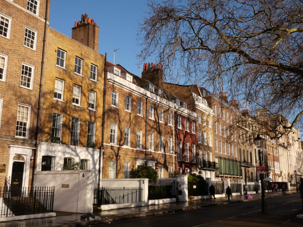
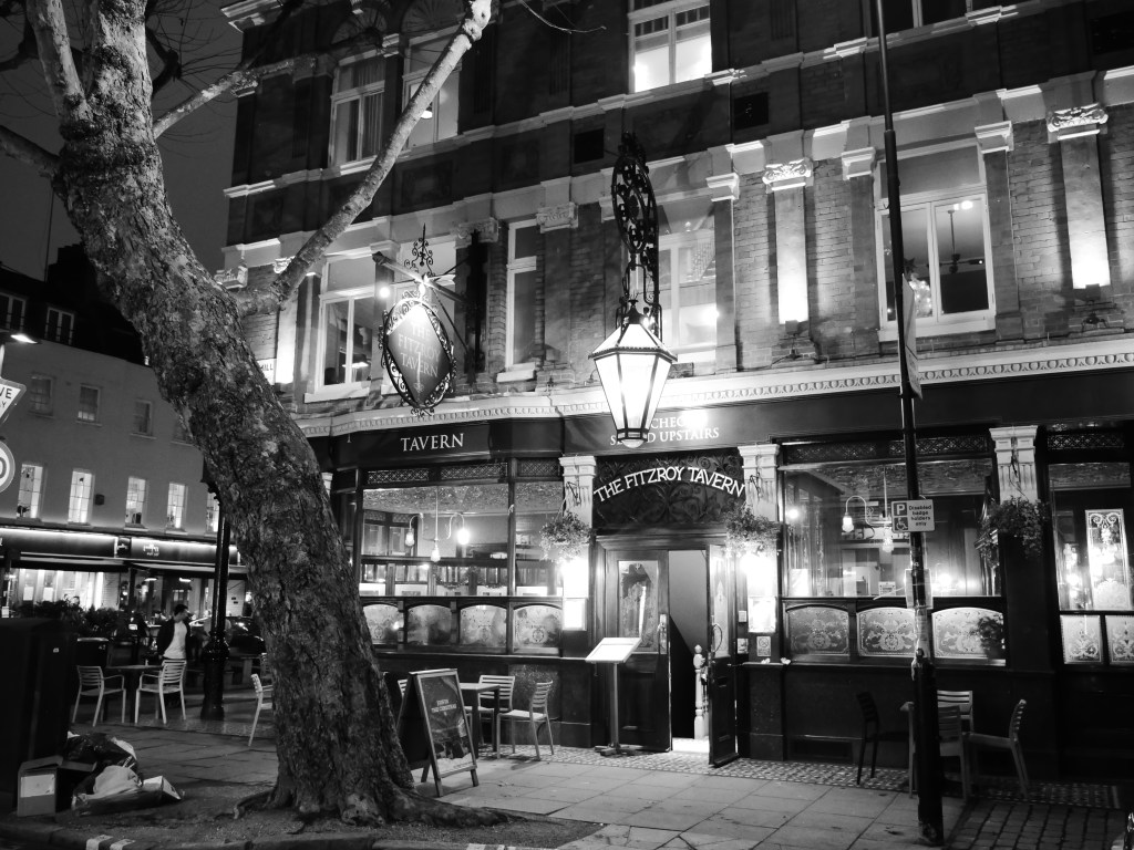
Development came to the Fitzrovia neighborhood starting along Oxford Road and Oxford Circle where more regal mid to late 18th century architecture was built for the noble classes. But the bulk of Fitzrovia’s development occurred during the late 18th and early century lined with middle class Georgian Terrace Housing lacking the more elegant square garden housing widespread in neighboring Bloomsbury and Soho (with the exception of Fitzroy Square). The name “Fitzrovia” came into use in the late 1930s among an artistic, bohemian circle that gathered at Fitzroy Tavern. The neighborhood was a cheaper alternative to surrounding West End neighborhoods.  The neighborhood was home to writers such as Virginia Woolf and George Bernard Shaw. Fitzrovia became even more disinvested in the 60s & 70s and had a good amount of vacancy in this era. But this did not last as reinvestment came to the area starting in the 90s moving it more inline economically with surrounding Central London Districts. Yet Fitzrovia has managed to maintain a good amount of economic diversity as many buildings have been maintained as low-moderate income housing association. Fitzrovia’s most prominent feature is the BT Tower on Cleveland Street which towers over the rest of the neighborhood. Fitzrovia also has a large daytime population (around 50K) and historically was a known for its fashion and advertising industries concentrated along Charlotte St.

From an urbanist perspective Fitzrovia’s is a very comfortable and walkable district with several small scaled business district, lots of mixed-use areas and convenient access to the West End, Oxford Circle and Central London thanks to its excellent subway connectivity. Outside of the Oxford Corridor Fitzrovia lacks the tourist buzz of many Central London Districts yet still manages to maintain a very vibrant restaurant, bar, and cultural scene. The two biggest issues I have with Fitzrovia is a lack of connected bike lanes and the stroad like Euston Rd forming its northern border. The population should also be higher (currently at around 25K souls per square mile) as it is a center city European neighborhood that is in high demand. 

Click here to view my Fitzrovia Album on Flickr

URBAN STRENGTHS:

  • Oxford Street is a major shopping district filled with several department stores. One of London’s most famous streets.
  • Tottenham Cour, Mortimer/Goodge St and Great Portland are all solid medium sized biz districts. Charlotte St/Rathbone is very active more intimate commercial street.
  • Great mix-use fabric and most blocks in Fitzrovia including plenty of universities and colleges. Jane Jacobs would love this district. About 50K people work in this small district.
  • Major TOD nodes with lots of modern office along
  • Mix of historic and infill. Generally at 3-7 stories.
  • BT tower should have a great view of the city.
  • Other than Oxford Street, Fitzrovia is not overwhelmingly touristy.
  • Great subway access including 7 metro stops served by 7 transit lines.
  • While parks within Fitzrovia are small and limited, the expansive Regent’s Park is located just to the northwest of the neighborhood.
  • Great night life here including tons of restaurants, bars, & cafes, plenty of live music venues and several cinemas and performing arts venues. Also a great array of museums and art galleries.
  • Decent urban density at around 25K people per square mile.

URBAN STRENGTHS:

* Some well designed and vibrant urban squares and parks but just not enough of them. These include Crabtree Fields, Pearson Square, Whitfield Gardens, the Warren Park. Fitzroy Square Garden is an excellent park surrounding by elegant surrounding terrace housing but the park is unfortunately private.
* Tree canopy is also not surprisingly, limited.
* Some dedicated bike lane segments but not a great network.
* Euston Rd is a busy 6 lane arterial framing the northern edge of Fitzrovia. 

Bloomsbury- Central London District known for its Terraced Housing, Gorgeous Urban Squares, and Wonderful Concentration of Museums, Universities, and Institutions.

The boundaries for Bloomsbury are a bit vague. For the purposes of my Bloomsbury neighborhood review I consider the district to be bounded by Bloomsbury/Great Ormond to the South, Grays Inn to the East, Tottenham Ct Rd to the west, and Euston Rd to the north.

Development really got started in the district with the construction of Bloomsbury square and surrounding terrace housing by the 4th Earl of Southampton right after the Great Fire in the 1660s. This was one of London’s first square developments. Development slowly continued in the 18th century but it wasn’t until the early 19th century that Bloomsbury filled in as the Duke of Bedford financed many affluent Georgian style terrace housing developed by the famous James Burton responsible for building around 3 thousand Georgian style terrace housing typically surrounding Parks and Square. Much of Bloomsbury is still owned by the Bedford Estate. Because of this concentration of elegant Georgian style terrace housing Bloomsbury has one of the highest proportions of historically listed buildings and monuments per square meter of any conservation district in London.

Modern Day Bloomsbury is an interesting mix of large institutional uses and museums (i.e. University of London & the British Museum), many historic Terrace housing developments with pockets of mid-century infill and more modern infill due to the district’s gentrification. There are also a number of the classic Mews lanes (compact rowhouses lined along dead-end narrow streets behind more prominent terrace housing). A good example of this is the Gower Mews. Overall Bloomsbury is a great urban district with solid density, wonderful cultural institutions & museums, vibrant streets, world class subway access providing convenient access to all of Central London, and a great array of urban parks and plazas, which are mostly open to the public. If I’m being nit-picky I’d like to see a bit more density in Bloomsbury, but this would need to be carefully done not to destroy some of the district’s monumental and gorgeous terrace housing. Bloomsbury could also use more extensive bike lane infrastructure and better tree canopy. 

Click here to view my Bloomsbury Album on Flickr

URBAN STRENGTHS:

*  Euston is a very busy and car heavy east-west street. Tottenham Cut and Bloomsbury Way are other very active streets with all modes of transportation and much more human scale than Euston.
* Nice narrow/quasi pedestrian streets at Museum St & Little Russel. Nice two block biz district along Southampton Row. Good amount of mixed-use blocks on mostly residential streets but less so than neighboring Holborn.
* Great Gardens and parks in Bloomsburg and most of the are open to the public. Bloomsburg Square Garden, Russel Square, Montague Street Gardens, Tavistock Square, Gordan Square,  Woburn Square, Brunswick Square Gardens, Mecklenburgh Square, St. George’s Garden,  Regent Square Garden, Bramber Green, Argyle Square, Cartwright Gardens. Many of these squares are  lined with gorgeous 18th and 19th century flats.
* Several well known destinations and landmarks including St. Pancras Station, King’s Cross, Euston Station, the British Library, The British Museum, the University of London (which includes many great historic landmarks of its own), the Charles Dickens Museum, the Wellcome Collection, Grant Museum of Zoology, St. Pancreas Church, St. George’s Church. Many other smaller museums and cultural sites.
* Other than Museums great array of restaurants, bars, cafes, live music venues and theaters. Solid retail amenities as well including the Brunswick Centre is an interesting modern Brutalist development including a residential building with a shopping centre at ground floor and a major plaza space.
* Better density than most central city London Districts of nearly 30K residents per square mile. Given all the space dedicated to institutional uses this is likely due to the large University of London population.
* Very vibrant district thanks to all the college students and institutional uses.
* Great subway access and 8 metro stops and 8 lines.
* Better bike lane infrastructure than most Central London districts including two bike lanes that span the district.

URBAN WEAKNESSES:

* Decent amount of biking occurs here, but any bike lanes are very short segments.
* A bit on the touristy side but not overwhelming.
* Other than the park space tree canopy is pretty limited.
* Decent density  (25K per square mile) and bit better than Farrington to the east but pretty low compared to most European central cities.
* Better tree cover than most Central London district but still underwhelming compared to a City like Parks. 

Holborn- Central London Neighborhood located on the Western Edge of the City of London

Holborn is a Central City neighborhood with sitting just west of the City of London. The neighborhood has roots in the ancient parish of Holborn, which lay on the west bank of the now buried River Fleet. The westward growth of London beyond the City Wall, and towards the seat of government in Westminster, took place along the banks of the River Thames and along the roads leading from Ludgate (Fleet Street and The Strand) and Newgate (Holborn/High Holborn). The westward growth towards Westminster accelerated in the 16th century(the Tudor Era) and the Fire of London in 1666 pushed growth in Holborn further northward away from the Thames River. The northern fringe of Holborn filled in during the 18th century. 

Modern day Holborn is a highly walkable district with convenient access to the plethora of professional jobs in the City of London along with the West end, Covet Garden, and the major train stations of King Cross & St. Pancras. The built environment of Holborn is mostly 4-7 story mixed use buildings built between the 17th-20th centuries with more monumental buildings along its southern edge (i.e. Fleet St., and the Strand). Holborn really excels at creating the type of mixed-use environment that Jane Jacobs so desired as most streets have some level of non-residential uses. This givens Holborn much more of a medieval feel where use types were much more flexible than even a turn of the 20th century NYC Manhattan neighborhood which tended to concentrate commercial uses on busy linear streets. This lends helps create a district with a vibrant retail, office, and cultural scene having a level of street activity far exceeding its 25K residents (per square mile) would typically justify. There are still some areas for improvement as bike infrastructure is limited to short segments, the tree canopy is concentrated only in parks, and a density of 25K people per square mile feels pretty underwhelming for a Inner City European neighborhood.

Click here to view my Holborn neighborhood on Flickr

URBAN STRENGTHS:


* Holborn is the major west-east corridor and is very active with pedestrian and bike activity. Bloomsbury & Kingsway are similar streets but with less activity and commercial uses.
* Red Lion/Lamb’s Conduit is a nice quasi intimate pedestrian street.
* Other good urban biz streets include Grays Inn, the Strand, and lots of other mixed-use blocks especially along the western edge. 
* Major landmarks here include Temple Church, Kings College, Somerset House, Waterhouse Square. Sir John Soane’s Museum,
* Several great parks as well including: Lincoln’s Inn Field North Lawn Garden, B, Red Square Gardens, & Grey’s Inn Square.
*  Even outside of the major landmarks architecture is comprised of largely gorgeous styles from the late 17th century-early 20th century with some more modern infill sprinkled throughout the district.
* Well connected to the Tube with 4 stations and 6 lines serving the district.
* Excellent cultural amenities here including tons of restaurants, bars, cares, museums, theaters, & cinemas. Great retail amenities as well. Everything is very convenient here. Great mixed-use fabric that would make Jane Jacobs proud. 

URBAN WEAKNESSES:

* Decent amount of bike occurs here, but any bike lanes are very short segments.
* A bit on the touristy side but not overwhelming.
* Other than the park space tree canopy is pretty limited.
* Decent density  (25K per square mile) and bit better than Farrington to the east but pretty low compared to most European central cities.

Farringdon- Central London District located north of Smithfield Market & Scene of several of Charles Dicken’s Novels

Farringdon is located in the London Borough of Islington located just north of the City of London with Smithfield Market being its southern border. The Smithfield Market dates back to 1133 and has been continually operating ever since, even escaping destruction from the London Fire of 1666. However, the City of London has sealed the fate of this storied market with plans to close it in 2028. The Farrington neighborhood grew up north from the Smithfield Market after the Great Fire along the Great North Road, which traces the modern day streets of St John & Islington High Streets. The Great Fire of London prompted the expansion of London beyond the traditional City of London boundaries north of the Roman Walls. By the early 1810s Farringdon was fully developed. However much of the northern half of Farrington was considered a slum in the first half of the 19th century and featured frequently in Charles Dicken’s Oliver Twist and David Copperfield novels.

The Smithfield market was reconstructed in the 1860s in a stunning new Victorian era building. This era also included  the construction of a road over the River Fleet which served as the northeastern terminus of the world’s first underground subway, the Metropolitan Railway, Several urban renewal projects in this time period also helped lift Farrington out of poverty and into a more “respectable” working class neighborhood specializing in  printing, brewing, and watchmaking. However after WWII Farrington experienced another period of decline. The neighborhood slowly emerged out of several decades of decline by the 1980s as Farringdon became a desirable place for artists desiring cheap loft space. By the late 1990s, gentrification was in full swing and Farrington became a desirable area for white collar works. In the early 2020s transit improvements to Farringdon station and the creation of the Elizabeth line have further spurred development  and increased real estate values.

From an urban perspective Farrington is an attractive highly walkable mixed-use district with excellent public transit and access to central London with decent bike infrastructure and comfortable human scale design. Major amenities include Smithfield Market, Exmouth Market, the St. John’s Biz District, and several attractive urban parks. Given its medium density of around 15K residents per square mile (very low for a Central European City) I’d like to see more intensive development especially around Farringdon Metro Station. There is new construction here but its mostly 4-5 stories and I believe this area should have more residential high-rises to take advantage of its TOD access and Farringdon’s Central London location.

Click here to view my Farringdon Album on Flickr

URBAN STRENGTHS:

* Excellent pedestrian scaled biz district on Exmouth Market. Also nice biz district on St. John’s St.
* Leather Lane is a very interesting compact biz district. More on the gritty side but has markets sometimes. Parts of it have been pedestrianized.  Hatton garden is only a block over from Leather lane and is a historic jewelry district.
* Good biz district along Clerkenwell Rd and Farringdon but wider streets than St. John’s St so not as intimate.
*  Nice mix of more historic Eastend Central London 18th & 19th century architecture on narrow medieval streets mixed with more spacious modern styles. 
* St. Peter’s Italian Catholic Church is a very interesting 19th century church tucked into the urban fabric. S]
* Three subway stations (i.e. Chancery Lane Station, Farringdon & Barbican) serve the neighborhood which includes 4 different subway lines.
* Not a terribly touristy area. Seems very livable.
* Very mixed use and amenity rich district.

URBAN WEAKNESSES:

  • Better park spaces than most Central London neighborhoods (i.e. St. James’ Garden, Spa Fields & Chaterhouse Square, St. John’s Garden) but still kinda limited. Tree canopy is so so.
  • Decent bike lane infrastructure but still some gaps in the two main lanes along Clerkenwell & Farringdon.
  • So so density for a central European neighborhood at around 15K-20K people per square mile.